Cournonterral (Cournonterral)

- commune in Hérault, France
- Country:

- Postal Code: 34660
- Coordinates: 43° 33' 28" N, 3° 43' 8" E


- GPS tracks (wikiloc): [Link]
- AboveSeaLevel: 50 м m
- Area: 28.62 sq km
- Population: 5790
- Web site: http://www.ville-cournonterral.fr
- Wikipedia en: wiki(en)
- Wikipedia: wiki(fr)
- Wikidata storage: Wikidata: Q196035
- Wikipedia Commons Gallery: [Link]
- Wikipedia Commons Category: [Link]
- Freebase ID: [/m/02vnp1m]
- Freebase ID: [/m/02vnp1m]
- GeoNames ID: Alt: [3022986]
- GeoNames ID: Alt: [3022986]
- SIREN number: [213400880]
- SIREN number: [213400880]
- BnF ID: [15256689x]
- BnF ID: [15256689x]
- VIAF ID: Alt: [141946421]
- VIAF ID: Alt: [141946421]
- Library of Congress authority ID: Alt: [n85340623]
- Library of Congress authority ID: Alt: [n85340623]
- WOEID: [587513]
- WOEID: [587513]
- INSEE municipality code: 34088
- INSEE municipality code: 34088
Shares border with regions:


Cournonsec
- commune in Hérault, France
- Country:
- Postal Code: 34660
- Coordinates: 43° 32' 55" N, 3° 42' 17" E
- GPS tracks (wikiloc): [Link]
- Area: 12.06 sq km
- Population: 3234
- Web site: [Link]


Saint-Paul-et-Valmalle
- commune in Hérault, France
- Country:
- Postal Code: 34570
- Coordinates: 43° 37' 35" N, 3° 40' 29" E
- GPS tracks (wikiloc): [Link]
- Area: 12.72 sq km
- Population: 1091
- Web site: [Link]


Montbazin
- commune in Hérault, France
- Country:
- Postal Code: 34560
- Coordinates: 43° 30' 57" N, 3° 41' 46" E
- GPS tracks (wikiloc): [Link]
- AboveSeaLevel: 34 м m
- Area: 21.13 sq km
- Population: 2999

Aumelas
- commune in Hérault, France
- Country:
- Postal Code: 34230
- Coordinates: 43° 36' 10" N, 3° 35' 55" E
- GPS tracks (wikiloc): [Link]
- AboveSeaLevel: 295 м m
- Area: 58.26 sq km
- Population: 519
- Web site: [Link]

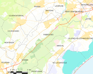
Fabrègues
- commune in Hérault, France
- Country:
- Postal Code: 34690
- Coordinates: 43° 33' 1" N, 3° 46' 34" E
- GPS tracks (wikiloc): [Link]
- Area: 31.46 sq km
- Population: 6739
- Web site: [Link]


Pignan
- commune in Hérault, France
- Country:
- Postal Code: 34570
- Coordinates: 43° 35' 3" N, 3° 45' 43" E
- GPS tracks (wikiloc): [Link]
- Area: 20.32 sq km
- Population: 6669
- Web site: [Link]