Coust (Coust)

- commune in Cher, France
- Country:

- Postal Code: 18210
- Coordinates: 46° 41' 33" N, 2° 35' 47" E


- GPS tracks (wikiloc): [Link]
- Area: 21.89 sq km
- Population: 452
- Web site: http://mairie.de.coust.free.fr
- Wikipedia en: wiki(en)
- Wikipedia: wiki(fr)
- Wikidata storage: Wikidata: Q1173464
- Wikipedia Commons Category: [Link]
- Freebase ID: [/m/03mfcmw]
- GeoNames ID: Alt: [3022834]
- SIREN number: [211800768]
- BnF ID: [15249422m]
- INSEE municipality code: 18076
Shares border with regions:

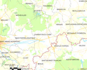
Charenton-du-Cher
- commune in Cher, France
- Country:
- Postal Code: 18210
- Coordinates: 46° 43' 47" N, 2° 38' 32" E
- GPS tracks (wikiloc): [Link]
- Area: 47.89 sq km
- Population: 1082

Colombiers
- commune in Cher, France
- Country:
- Postal Code: 18200
- Coordinates: 46° 42' 3" N, 2° 32' 24" E
- GPS tracks (wikiloc): [Link]
- Area: 9.51 sq km
- Population: 405


Ainay-le-Vieil
- commune in Cher, France
- Country:
- Postal Code: 18200
- Coordinates: 46° 40' 1" N, 2° 33' 7" E
- GPS tracks (wikiloc): [Link]
- Area: 13.77 sq km
- Population: 187
Lételon
- commune in Allier, France
- Country:
- Postal Code: 03360
- Coordinates: 46° 39' 22" N, 2° 35' 8" E
- GPS tracks (wikiloc): [Link]
- AboveSeaLevel: 197 м m
- Area: 6.37 sq km
- Population: 113

Braize
- commune in Allier, France
- Country:
- Postal Code: 03360
- Coordinates: 46° 40' 2" N, 2° 38' 59" E
- GPS tracks (wikiloc): [Link]
- Area: 20.95 sq km
- Population: 277


Saint-Pierre-les-Étieux
- commune in Cher, France
- Country:
- Postal Code: 18210
- Coordinates: 46° 44' 17" N, 2° 35' 37" E
- GPS tracks (wikiloc): [Link]
- Area: 27.34 sq km
- Population: 700