
Craco (Craco)
.svg)
- Italian comune
 Hiking in Craco
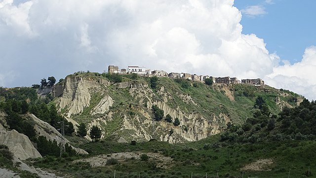
Craco is a fascinating destination for hiking enthusiasts, known for its unique landscape and historical significance. Located in the Basilicata region of southern Italy, Craco is a ghost town that was abandoned in the 1960s due to landslides and erosion. The eerie ruins of this once-thriving medieval village, perched on a hilltop, create a stunning backdrop for hiking adventures.
Hiking Highlights:
-
Historical Significance: As you hike, you'll encounter remnants of historical architecture, including churches, palaces, and homes that tell the story of Craco's rich past.
-
Scenic Views: The trails around Craco offer breathtaking views of the surrounding countryside, including the rolling hills, valleys, and farmlands of Basilicata. The sunsets here can be particularly stunning.
-
Trail Variety: There are various trails to explore, ranging from easy walks around the outskirts of Craco to more challenging routes that lead into the surrounding hills. Some paths may be steeper or rocky, so proper footwear is important.
-
Flora and Fauna: The area is home to diverse wildlife and plant species, making it an interesting spot for nature lovers. You may see various birds and native plants along your hike.
-
Cultural Exploration: Besides the ruins, hikers can take part in cultural events or local festivals that may occur throughout the year, giving insight into the region's traditions.
Important Tips:
-
Preparation: Wear appropriate hiking shoes and clothing. The terrain can be uneven, and temperatures can vary, so be prepared for changing conditions.
-
Stay Hydrated: Bring plenty of water, especially during warmer months, and consider packing snacks for energy.
-
Respect the Environment: As a historical site, it's important to tread lightly and avoid damaging any structures or natural features.
-
Guided Tours: Consider joining a guided hike if you're unfamiliar with the area. Local guides can provide invaluable insights into the history and geography of Craco.
-
Visit Nearby Areas: If time allows, explore nearby towns or natural parks for additional hiking opportunities and cultural experiences.
Hiking in Craco combines natural beauty, history, and a touch of adventure that can make for an unforgettable experience. Enjoy your hike!
- Country:

- Postal Code: 75010
- Local Dialing Code: 0835
- Licence Plate Code: MT
- Coordinates: 40° 23' 0" N, 16° 26' 0" E


- GPS tracks (wikiloc): [Link]
- AboveSeaLevel: 391 м m
- Area: 77.04 sq km
- Population: 725
- Web site: http://www.comune.craco.mt.it
- Wikipedia en: wiki(en)
- Wikipedia: wiki(it)
- Wikidata storage: Wikidata: Q52285
- Wikipedia Commons Gallery: [Link]
- Wikipedia Commons Category: [Link]
- Freebase ID: [/m/0fgv05]
- Freebase ID: [/m/0fgv05]
- GeoNames ID: Alt: [6537645]
- GeoNames ID: Alt: [6537645]
- VIAF ID: Alt: [242806563]
- VIAF ID: Alt: [242806563]
- OSM relation ID: [40462]
- OSM relation ID: [40462]
- Digital Atlas of the Roman Empire ID: [29205]
- Digital Atlas of the Roman Empire ID: [29205]
- ISTAT ID: 077007
- ISTAT ID: 077007
- Italian cadastre code: D128
- Italian cadastre code: D128
Shares border with regions:


Ferrandina
- Italian comune
Hiking in Ferrandina
Ferrandina is a charming town located in the Basilicata region of southern Italy, surrounded by beautiful landscapes that offer various hiking opportunities. Here are some key points to consider when hiking in and around Ferrandina:...
- Country:
- Postal Code: 75013
- Local Dialing Code: 0835
- Licence Plate Code: MT
- Coordinates: 40° 30' 0" N, 16° 27' 0" E
- GPS tracks (wikiloc): [Link]
- AboveSeaLevel: 420 м m
- Area: 218.11 sq km
- Population: 8727
- Web site: [Link]

Montalbano Jonico
- Italian comune
Hiking in Montalbano Jonico
Montalbano Jonico, located in the Basilicata region of Italy, is a charming town that offers beautiful landscapes and opportunities for hiking enthusiasts. The area is characterized by rolling hills, stunning views, and a rich natural environment that includes vineyards, olive groves, and Mediterranean vegetation....
- Country:
- Postal Code: 75023
- Local Dialing Code: 0835
- Licence Plate Code: MT
- Coordinates: 40° 17' 0" N, 16° 34' 0" E
- GPS tracks (wikiloc): [Link]
- AboveSeaLevel: 292 м m
- Area: 136 sq km
- Population: 7208
- Web site: [Link]


Pisticci
- Italian comune
Hiking in Pisticci
Pisticci, located in the Basilicata region of Southern Italy, offers a fascinating blend of natural beauty and rich cultural heritage, making it an intriguing destination for hikers. The region is characterized by its distinct landscapes, which include rolling hills, rocky terrains, and stunning views of the surrounding countryside....
- Country:
- Postal Code: 75020; 75015; 75010
- Local Dialing Code: 0835
- Licence Plate Code: MT
- Coordinates: 40° 23' 0" N, 16° 33' 0" E
- GPS tracks (wikiloc): [Link]
- AboveSeaLevel: 364 м m
- Area: 233.67 sq km
- Population: 17602
- Web site: [Link]
San Mauro Forte
- Italian comune
Hiking in San Mauro Forte
San Mauro Forte is a charming hilltop village located in the Basilicata region of southern Italy. Known for its stunning landscapes and rich history, it offers a unique experience for hikers who are looking to explore the natural beauty of the area....
- Country:
- Postal Code: 75010
- Local Dialing Code: 0835
- Licence Plate Code: MT
- Coordinates: 40° 29' 0" N, 16° 15' 0" E
- GPS tracks (wikiloc): [Link]
- AboveSeaLevel: 540 м m
- Area: 87.06 sq km
- Population: 1473
- Web site: [Link]


Stigliano
- Italian comune
Hiking in Stigliano
Stigliano is a charming town located in the Basilicata region of southern Italy, known for its beautiful landscapes and opportunities for outdoor activities, including hiking. While the town might not be as famous as some other Italian hiking destinations, it offers a unique experience for outdoor enthusiasts who are looking to explore scenic trails and enjoy nature....
- Country:
- Postal Code: 75018
- Local Dialing Code: 0835
- Licence Plate Code: MT
- Coordinates: 40° 24' 9" N, 16° 13' 47" E
- GPS tracks (wikiloc): [Link]
- AboveSeaLevel: 909 м m
- Area: 211.15 sq km
- Population: 4112
- Web site: [Link]