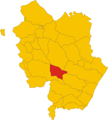
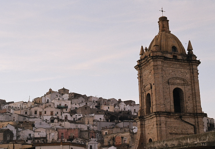
Ferrandina (Ferrandina)
.svg)
- Italian comune
 Hiking in Ferrandina
Ferrandina is a charming town located in the Basilicata region of southern Italy, surrounded by beautiful landscapes that offer various hiking opportunities. Here are some key points to consider when hiking in and around Ferrandina:
-
Scenic Trails: The area is characterized by rolling hills, vineyards, and agricultural land, making for picturesque trails. Hiking in Ferrandina allows you to experience the natural beauty of the Apennine Mountains.
-
Historical Sites: As you hike, you may encounter historical landmarks, such as ancient ruins or traditional villages. Nature and history often converge in charming ways in this region.
-
Nearby Natural Parks: The proximity of Ferrandina to the Cilento, Vallo di Diano, and Lucanian Dolomites National Parks provides fantastic hiking opportunities. Each park boasts unique flora and fauna, as well as dramatic landscapes.
-
Moderate Climate: The climate in the Basilicata region is generally mild, making hiking pleasurable most of the year. However, spring and autumn are especially lovely for hikes, as the temperatures are comfortable, and the landscapes are vibrant.
-
Wildlife: The area is home to a variety of wildlife, adding to the experience of hiking. Keep an eye out for local fauna and be respectful of their natural habitats.
-
Local Culture: Don’t miss the chance to experience local culture through its cuisine, which is hearty and flavorful. After a day of hiking, enjoy traditional dishes featuring local ingredients.
-
Guided Tours: Consider joining guided hiking tours if you're unfamiliar with the area or prefer to learn about the local ecology and history from a knowledgeable source.
-
Preparation: As with any hiking adventure, ensure you are properly prepared with adequate gear, plenty of water, and a map or GPS device to navigate the trails.
Overall, hiking in Ferrandina offers a blend of natural beauty, cultural richness, and enjoyable outdoor activity. Whether you're a seasoned hiker or a beginner, you'll find trails that suit your ability and preferences.
- Country:

- Postal Code: 75013
- Local Dialing Code: 0835
- Licence Plate Code: MT
- Coordinates: 40° 30' 0" N, 16° 27' 0" E


- GPS tracks (wikiloc): [Link]
- AboveSeaLevel: 420 м m
- Area: 218.11 sq km
- Population: 8727
- Web site: http://www.comune.ferrandina.mt.it
- Wikipedia en: wiki(en)
- Wikipedia: wiki(it)
- Wikidata storage: Wikidata: Q52286
- Wikipedia Commons Gallery: [Link]
- Wikipedia Commons Category: [Link]
- Freebase ID: [/m/0fgv0l]
- Freebase ID: [/m/0fgv0l]
- GeoNames ID: Alt: [6541947]
- GeoNames ID: Alt: [6541947]
- VIAF ID: Alt: [126766207]
- VIAF ID: Alt: [126766207]
- OSM relation ID: [40507]
- OSM relation ID: [40507]
- WOEID: [715397]
- WOEID: [715397]
- TGN ID: [1044584]
- TGN ID: [1044584]
- UN/LOCODE: [ITERR]
- UN/LOCODE: [ITERR]
- Digital Atlas of the Roman Empire ID: [29212]
- Digital Atlas of the Roman Empire ID: [29212]
- ISTAT ID: 077008
- ISTAT ID: 077008
- Italian cadastre code: D547
- Italian cadastre code: D547
Shares border with regions:

Craco
- Italian comune
Hiking in Craco
Craco is a fascinating destination for hiking enthusiasts, known for its unique landscape and historical significance. Located in the Basilicata region of southern Italy, Craco is a ghost town that was abandoned in the 1960s due to landslides and erosion. The eerie ruins of this once-thriving medieval village, perched on a hilltop, create a stunning backdrop for hiking adventures....
- Country:
- Postal Code: 75010
- Local Dialing Code: 0835
- Licence Plate Code: MT
- Coordinates: 40° 23' 0" N, 16° 26' 0" E
- GPS tracks (wikiloc): [Link]
- AboveSeaLevel: 391 м m
- Area: 77.04 sq km
- Population: 725
- Web site: [Link]
Grottole
- Italian comune
Hiking in Grottole
Grottole is a charming village located in the Basilicata region of Southern Italy, known for its beautiful landscapes and rich historical heritage. It's a great spot for hiking enthusiasts looking to explore the natural beauty and cultural sites of this lesser-known area. Here are some key points about hiking in and around Grottole:...
- Country:
- Postal Code: 75010
- Local Dialing Code: 0835
- Licence Plate Code: MT
- Coordinates: 40° 36' 12" N, 16° 22' 42" E
- GPS tracks (wikiloc): [Link]
- AboveSeaLevel: 481 м m
- Area: 117.15 sq km
- Population: 2116
- Web site: [Link]


Miglionico
- Italian comune
Hiking in Miglionico
Miglionico is a charming village located in the Basilicata region of southern Italy, surrounded by beautiful landscapes and offering a variety of outdoor activities, including hiking. The area is characterized by its rolling hills, vineyards, and olive groves, as well as its rich history and cultural heritage....
- Country:
- Postal Code: 75010
- Local Dialing Code: 0835
- Licence Plate Code: MT
- Coordinates: 40° 34' 0" N, 16° 30' 0" E
- GPS tracks (wikiloc): [Link]
- AboveSeaLevel: 465 м m
- Area: 88.84 sq km
- Population: 2454
- Web site: [Link]


Pisticci
- Italian comune
Hiking in Pisticci
Pisticci, located in the Basilicata region of Southern Italy, offers a fascinating blend of natural beauty and rich cultural heritage, making it an intriguing destination for hikers. The region is characterized by its distinct landscapes, which include rolling hills, rocky terrains, and stunning views of the surrounding countryside....
- Country:
- Postal Code: 75020; 75015; 75010
- Local Dialing Code: 0835
- Licence Plate Code: MT
- Coordinates: 40° 23' 0" N, 16° 33' 0" E
- GPS tracks (wikiloc): [Link]
- AboveSeaLevel: 364 м m
- Area: 233.67 sq km
- Population: 17602
- Web site: [Link]

Pomarico
- Italian comune
Hiking in Pomarico
Pomarico is a small town located in the Basilicata region of Italy, surrounded by beautiful landscapes that offer various opportunities for hiking and outdoor activities. While Pomarico itself is not a major hiking destination, it serves as a great starting point for exploring the surrounding areas, particularly the nearby hills and countryside....
- Country:
- Postal Code: 75016
- Local Dialing Code: 0835
- Licence Plate Code: MT
- Coordinates: 40° 31' 0" N, 16° 33' 0" E
- GPS tracks (wikiloc): [Link]
- AboveSeaLevel: 459 м m
- Area: 129.67 sq km
- Population: 4084
- Web site: [Link]
Salandra
- Italian comune
Hiking in Salandra
Salandra is a small town in the Basilicata region of Italy, known for its picturesque landscapes and historical significance. While it's not widely recognized as a major hiking destination, the surrounding areas offer some beautiful trails and opportunities for outdoor exploration....
- Country:
- Postal Code: 75017
- Local Dialing Code: 0835
- Licence Plate Code: MT
- Coordinates: 40° 32' 0" N, 16° 19' 0" E
- GPS tracks (wikiloc): [Link]
- AboveSeaLevel: 598 м m
- Area: 77.44 sq km
- Population: 2745
- Web site: [Link]
San Mauro Forte
- Italian comune
Hiking in San Mauro Forte
San Mauro Forte is a charming hilltop village located in the Basilicata region of southern Italy. Known for its stunning landscapes and rich history, it offers a unique experience for hikers who are looking to explore the natural beauty of the area....
- Country:
- Postal Code: 75010
- Local Dialing Code: 0835
- Licence Plate Code: MT
- Coordinates: 40° 29' 0" N, 16° 15' 0" E
- GPS tracks (wikiloc): [Link]
- AboveSeaLevel: 540 м m
- Area: 87.06 sq km
- Population: 1473
- Web site: [Link]