Croisilles (Croisilles)

- commune in Eure-et-Loir, France
- Country:

- Postal Code: 28210
- Coordinates: 48° 41' 20" N, 1° 30' 15" E


- GPS tracks (wikiloc): [Link]
- Area: 5.72 sq km
- Population: 458
- Wikipedia en: wiki(en)
- Wikipedia: wiki(fr)
- Wikidata storage: Wikidata: Q569022
- Wikipedia Commons Category: [Link]
- Freebase ID: [/m/03nqt1k]
- GeoNames ID: Alt: [6430711]
- SIREN number: [212801187]
- BnF ID: [15254049j]
- INSEE municipality code: 28118
Shares border with regions:


Bréchamps
- commune in Eure-et-Loir, France
- Country:
- Postal Code: 28210
- Coordinates: 48° 40' 20" N, 1° 31' 17" E
- GPS tracks (wikiloc): [Link]
- Area: 5.43 sq km
- Population: 325
- Web site: [Link]

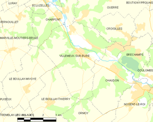
Villemeux-sur-Eure
- commune in Eure-et-Loir, France
- Country:
- Postal Code: 28210
- Coordinates: 48° 40' 24" N, 1° 27' 43" E
- GPS tracks (wikiloc): [Link]
- Area: 18.59 sq km
- Population: 1614
- Web site: [Link]