Crosmières (Crosmières)

- commune in Sarthe, France
- Country:

- Postal Code: 72200
- Coordinates: 47° 44' 45" N, 0° 9' 5" E


- GPS tracks (wikiloc): [Link]
- AboveSeaLevel: 61 м m
- Area: 20.45 sq km
- Population: 1045
- Web site: http://crosmieres.mairie72.fr
- Wikipedia en: wiki(en)
- Wikipedia: wiki(fr)
- Wikidata storage: Wikidata: Q541844
- Wikipedia Commons Category: [Link]
- Freebase ID: [/m/03qkzrh]
- GeoNames ID: Alt: [6442556]
- SIREN number: [217201102]
- BnF ID: [15273666z]
- INSEE municipality code: 72110
- GNS Unique Feature ID: -1423049
Shares border with regions:


Bazouges-sur-le-Loir
- former commune in Sarthe, France
- Country:
- Postal Code: 72200
- Coordinates: 47° 41' 25" N, 0° 10' 7" E
- GPS tracks (wikiloc): [Link]
- Area: 29.9 sq km
- Population: 1269
- Web site: [Link]

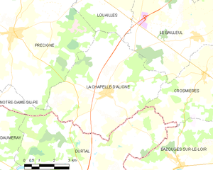
La Chapelle-d'Aligné
- commune in Sarthe, France
- Country:
- Postal Code: 72300
- Coordinates: 47° 43' 58" N, 0° 14' 11" E
- GPS tracks (wikiloc): [Link]
- Area: 33.04 sq km
- Population: 1660


La Flèche
- commune in Sarthe, France
- Country:
- Postal Code: 72200
- Coordinates: 47° 41' 59" N, 0° 4' 34" E
- GPS tracks (wikiloc): [Link]
- Area: 74.21 sq km
- Population: 15185
- Web site: [Link]


Villaines-sous-Malicorne
- commune in Sarthe, France
- Country:
- Postal Code: 72270
- Coordinates: 47° 45' 49" N, 0° 6' 2" E
- GPS tracks (wikiloc): [Link]
- Area: 19.16 sq km
- Population: 1031


Le Bailleul
- commune in Sarthe, France
- Country:
- Postal Code: 72200
- Coordinates: 47° 46' 7" N, 0° 9' 40" E
- GPS tracks (wikiloc): [Link]
- Area: 27.46 sq km
- Population: 1240
- Web site: [Link]

Durtal
- commune in Maine-et-Loire, France
- Country:
- Postal Code: 49430
- Coordinates: 47° 40' 19" N, 0° 14' 29" E
- GPS tracks (wikiloc): [Link]
- Area: 60.58 sq km
- Population: 3371
- Web site: [Link]