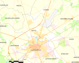
Déols (Déols)
- commune in Indre, France
- Country:

- Postal Code: 36130
- Coordinates: 46° 49' 48" N, 1° 42' 21" E


- GPS tracks (wikiloc): [Link]
- Area: 31.74 sq km
- Population: 7598
- Web site: http://www.ville-deols.fr
- Wikipedia en: wiki(en)
- Wikipedia: wiki(fr)
- Wikidata storage: Wikidata: Q473103
- Wikipedia Commons Category: [Link]
- Freebase ID: [/m/08x2rb]
- GeoNames ID: Alt: [3021570]
- SIREN number: [213600638]
- BnF ID: [152573671]
- VIAF ID: Alt: [159471927]
- GND ID: Alt: [4342066-7]
- Library of Congress authority ID: Alt: [n82120768]
- PACTOLS thesaurus ID: [pcrtX4uX5bqW61]
- WOEID: [588630]
- Digital Atlas of the Roman Empire ID: [13454]
- INSEE municipality code: 36063
Shares border with regions:


Étrechet
- commune in Indre, France
- Country:

- Postal Code: 36120
- Coordinates: 46° 46' 43" N, 1° 47' 5" E


- GPS tracks (wikiloc): [Link]
- Area: 17.89 sq km
- Population: 955
- Web site: [Link]
Coings
- commune in Indre, France
- Country:

- Postal Code: 36130
- Coordinates: 46° 53' 11" N, 1° 42' 56" E


- GPS tracks (wikiloc): [Link]
- Area: 29.33 sq km
- Population: 822

Vineuil
- commune in Indre, France
- Country:

- Postal Code: 36110
- Coordinates: 46° 54' 3" N, 1° 38' 7" E


- GPS tracks (wikiloc): [Link]
- Area: 44.41 sq km
- Population: 1225

Villers-les-Ormes
- former commune in Indre, France
- Country:

- Postal Code: 36250
- Coordinates: 46° 52' 11" N, 1° 37' 58" E


- GPS tracks (wikiloc): [Link]
- Area: 17.6 sq km
- Population: 449

Saint-Maur
- former commune in Indre, France
- Country:

- Postal Code: 36250
- Coordinates: 46° 48' 23" N, 1° 38' 22" E


- GPS tracks (wikiloc): [Link]
- Area: 70.31 sq km
- Population: 3112
- Web site: [Link]


Châteauroux
- commune in Indre, France
- Country:

- Postal Code: 36000
- Coordinates: 46° 48' 35" N, 1° 41' 25" E


- GPS tracks (wikiloc): [Link]
- Area: 25.54 sq km
- Population: 43732
- Web site: [Link]


Montierchaume
- commune in Indre, France
- Country:

- Postal Code: 36130
- Coordinates: 46° 51' 48" N, 1° 46' 33" E


- GPS tracks (wikiloc): [Link]
- Area: 37.2 sq km
- Population: 1607
Diors
- commune in Indre, France
- Country:

- Postal Code: 36130
- Coordinates: 46° 49' 35" N, 1° 48' 53" E


- GPS tracks (wikiloc): [Link]
- Area: 25.44 sq km
- Population: 778
