Dürrröhrsdorf-Dittersbach (Dürrröhrsdorf-Dittersbach)

- municipality in the district of Sächsische Schweiz-Osterzgebirge, Germany
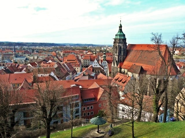
 Hiking in Dürrröhrsdorf-Dittersbach
Dürrröhrsdorf-Dittersbach is a beautiful area located in the Saxony region of Germany, known for its picturesque landscapes, charming villages, and numerous opportunities for outdoor activities, including hiking. Here are some highlights for hiking in this region:
Scenic Trails
-
Dürrröhrsdorf-Dittersbach Village Trails: The area features several well-marked hiking trails that take you through the charming village and surrounding countryside. This includes views of lush forests, rolling hills, and quaint Saxon architecture.
-
Saxon Switzerland National Park: Though not directly in Dürrröhrsdorf-Dittersbach, the park is nearby and offers some of the most stunning hiking in Germany. Famous for its sandstone formations, deep gorges, and breathtaking vistas, the trails range from easy walks to challenging scrambles.
-
Local Nature Reserve: The local flora and fauna can be appreciated on shorter trails around the area, perfect for family hikes or leisurely walks where you can observe wildlife and native plants.
Tips for Hiking
- Maps and Signage: Ensure you have a good hiking map or GPS device, as trails can vary in difficulty and maintenance.
- Weather Preparedness: Check the weather forecast before heading out, as conditions can change rapidly in the area.
- Footwear: Wear sturdy hiking boots, as some trails can be rocky or uneven.
- Hydration and Snacks: Bring enough water and snacks, especially if you plan to hike longer distances.
Local Attractions
After your hike, consider exploring the local culture. Dürrröhrsdorf-Dittersbach has a rich history, and you might find local museums or heritage sites that showcase the area's traditions.
Ideal Hiking Seasons
- Spring: For blooming wildflowers and mild temperatures.
- Autumn: For stunning fall foliage and cooler weather, ideal for hiking.
Conclusion
In summary, Dürrröhrsdorf-Dittersbach offers diverse hiking experiences, from local village trails to access to the remarkable landscapes of nearby Saxon Switzerland. Whether you're an experienced hiker or looking for a leisurely stroll, the region is a splendid destination for outdoor enthusiasts.
- Country:

- Postal Code: 01833
- Local Dialing Code: 035026
- Licence Plate Code: PIR
- Coordinates: 51° 2' 0" N, 14° 0' 0" E


- GPS tracks (wikiloc): [Link]
- AboveSeaLevel: 240 м m
- Area: 43.5 sq km
- Population: 4200
- Web site: https://www.duerrroehrsdorf-dittersbach.de/
- Wikipedia en: wiki(en)
- Wikipedia: wiki(de)
- Wikidata storage: Wikidata: Q6692
- Wikipedia Commons Category: [Link]
- Freebase ID: [/m/047p70]
- GeoNames ID: Alt: [2934286]
- VIAF ID: Alt: [150778109]
- OSM relation ID: [534520]
- GND ID: Alt: [4389982-1]
- Historical Gazetteer (GOV) ID: [DURACHJO71AA]
- German municipality key: 14628100
- German regional key: 146280100100
Includes regions:
Dittersbach
- village in Germany
Hiking in Dittersbach
Dittersbach, part of the town of Dürrröhrsdorf-Dittersbach in Saxony, Germany, offers beautiful landscapes and well-maintained hiking trails for outdoor enthusiasts. The region is known for its picturesque surroundings, with rolling hills, forests, and quaint villages, making it an attractive destination for hiking....
- Country:
- Postal Code: 01833
- Local Dialing Code: 035026
- Coordinates: 51° 2' 23" N, 13° 59' 0" E
- GPS tracks (wikiloc): [Link]
- AboveSeaLevel: 223 м m
Dobra
- village in Germany
Hiking in Dobra
Dobra, also known as Dürrröhrsdorf-Dittersbach, is a charming locality in Saxony, Germany, surrounded by beautiful natural landscapes ideal for hiking. Here are some highlights and tips for hiking in this region:...
- Country:
- Postal Code: 01833
- Local Dialing Code: 035026
- Coordinates: 51° 1' 6" N, 14° 1' 39" E
- GPS tracks (wikiloc): [Link]
- AboveSeaLevel: 280 м m
- Area: 4.78 sq km
Dürrröhrsdorf
- village in Germany
Hiking in Dürrröhrsdorf
Dürrröhrsdorf is a small village located in the Saxon Switzerland region of Germany, known for its stunning landscapes and excellent hiking opportunities. Here are some highlights and tips for hiking in and around Dürrröhrsdorf:...
- Country:
- Postal Code: 01833
- Local Dialing Code: 035026
- Coordinates: 51° 2' 2" N, 13° 59' 50" E
- GPS tracks (wikiloc): [Link]
- AboveSeaLevel: 224 м m
Porschendorf
- village in Germany
Hiking in Porschendorf
Porschendorf, located in Germany, offers a variety of hiking opportunities that cater to outdoor enthusiasts of all levels. The region is characterized by its beautiful landscapes, lush forests, and scenic trails. Here are some highlights for hiking in Porschendorf:...
- Country:
- Postal Code: 01833
- Local Dialing Code: 035026
- Coordinates: 51° 0' 45" N, 13° 59' 55" E
- GPS tracks (wikiloc): [Link]
- AboveSeaLevel: 200 м m
Wilschdorf
- village in Germany
Hiking in Wilschdorf
Wilschdorf is a small area located in the municipality of Dürrröhrsdorf-Dittersbach in Saxony, Germany. It is surrounded by beautiful landscapes, including forests, hills, and picturesque village scenes, making it a great spot for hiking enthusiasts....
- Country:
- Postal Code: 01833
- Local Dialing Code: 035026
- Coordinates: 51° 3' 22" N, 14° 0' 12" E
- GPS tracks (wikiloc): [Link]
- AboveSeaLevel: 246 м m
Stürza
- village in Germany
Hiking in Stürza
Stürza, while not widely known as a prominent hiking destination, offers various outdoor opportunities for nature lovers that are sure to please both novice and experienced hikers. Here’s a general outlook on what you might expect when exploring the hiking trails in Stürza and its surrounding areas:...
- Country:
- Postal Code: 01833
- Local Dialing Code: 035026
- Coordinates: 51° 0' 50" N, 14° 3' 30" E
- GPS tracks (wikiloc): [Link]
- AboveSeaLevel: 285 м m
- Area: 7.3 sq km
Wünschendorf (Dürrröhrsdorf-Dittersbach)
- village in Germany
Hiking in Wünschendorf (Dürrröhrsdorf-Dittersbach)
Wünschendorf, located near Dürrröhrsdorf-Dittersbach in Germany, is surrounded by beautiful landscapes that are ideal for hiking enthusiasts. The region is characterized by rolling hills, dense forests, and picturesque countryside, making it a perfect spot for both leisurely walks and more challenging hikes....
- Country:
- Postal Code: 01833
- Local Dialing Code: 035026
- Coordinates: 51° 1' 3" N, 13° 57' 20" E
- GPS tracks (wikiloc): [Link]
- AboveSeaLevel: 246 м m
- Area: 4.4 sq km
Elbersdorf
- village in Germany
Hiking in Elbersdorf
Elbersdorf may not be as widely recognized as many hiking destinations, but it offers opportunities for those looking to explore nature and enjoy outdoor activities. Depending on the specific location (as there may be several places named Elbersdorf in different regions), the hiking trails will vary in terms of scenery, difficulty, and length....
- Country:
- Postal Code: 01833
- Local Dialing Code: 035026
- Coordinates: 51° 1' 25" N, 13° 59' 20" E
- GPS tracks (wikiloc): [Link]
- AboveSeaLevel: 250 м m
- Area: 2.60 sq km
- Population: 370
Shares border with regions:


Dresden
- capital city of the Free State of Saxony in Germany
Hiking in Dresden
Dresden, located in eastern Germany, is not only known for its rich history and stunning architecture but also offers wonderful hiking opportunities in its surrounding areas. Here are some highlights:...
- Country:
- Postal Code: 01279; 01129; 01307; 01127; 01159; 01099; 01097; 01069; 01309; 01326; 01067
- Local Dialing Code: 35201; 351
- Licence Plate Code: DD
- Coordinates: 51° 2' 57" N, 13° 44' 18" E
- GPS tracks (wikiloc): [Link]
- AboveSeaLevel: 112 м m
- Area: 328.48 sq km
- Population: 550948
- Web site: [Link]


Bautzen District
- district in the state of Saxony in Germany
Hiking in Bautzen District
Bautzen, located in the eastern part of Germany, specifically in Saxony, offers a rich landscape for hiking enthusiasts. The district is characterized by its picturesque scenery, which includes rolling hills, dense forests, and winding rivers, particularly the Spree River. Here are some key highlights about hiking in Bautzen and its surroundings:...
- Country:
- Licence Plate Code: KM; HY; BZ; BIW
- Coordinates: 51° 17' 0" N, 14° 16' 0" E
- GPS tracks (wikiloc): [Link]
- AboveSeaLevel: 178 м m
- Area: 2390.70 sq km
- Population: 304691
- Web site: [Link]

Pirna
- town in the Free State of Saxony, Germany
Hiking in Pirna
Pirna, located in Germany’s Saxon Switzerland region, is a fantastic destination for hiking enthusiasts. The area is renowned for its stunning sandstone formations, deep gorges, and lush forests, making it a picturesque and diverse hiking environment....
- Country:
- Postal Code: 01796; 8300
- Local Dialing Code: 03501
- Licence Plate Code: PIR
- Coordinates: 50° 57' 44" N, 13° 56' 25" E
- GPS tracks (wikiloc): [Link]
- AboveSeaLevel: 118 м m
- Area: 53.06 sq km
- Population: 38310
- Web site: [Link]


Hohnstein
- town in the Sächsische Schweiz-Osterzgebirge district, in the Free State of Saxony, Germany
Hiking in Hohnstein
Hohnstein is a charming town located in Saxon Switzerland, Germany, an area known for its stunning natural landscapes, unique rock formations, and excellent hiking opportunities. Here are some highlights and tips for hiking in and around Hohnstein:...
- Country:
- Postal Code: 01848
- Local Dialing Code: 035975
- Licence Plate Code: PIR
- Coordinates: 50° 59' 0" N, 14° 7' 0" E
- GPS tracks (wikiloc): [Link]
- AboveSeaLevel: 330 м m
- Area: 64.61 sq km
- Population: 3301
- Web site: [Link]


Lohmen
- municipality in the Sächsische Schweiz-Osterzgebirge district, in Saxony, Germany
Hiking in Lohmen
Lohmen, located in Germany, is a fantastic destination for hiking enthusiasts, particularly for those who appreciate stunning landscapes and diverse natural settings. Situated near the Elbe River and nestled between the beautiful Elbe Sandstone Mountains, Lohmen offers a variety of trails that cater to different experience levels....
- Country:
- Postal Code: 01847
- Local Dialing Code: 035024; 03501
- Licence Plate Code: PIR
- Coordinates: 50° 59' 17" N, 14° 0' 17" E
- GPS tracks (wikiloc): [Link]
- AboveSeaLevel: 219 м m
- Area: 25.80 sq km
- Population: 3067
- Web site: [Link]


Stolpen
- town in the district of Sächsische Schweiz-Osterzgebirge, in the Free State of Saxony, Germany
Hiking in Stolpen
Stolpen, located in the Saxony region of Germany, is known for its scenic landscapes and historical significance. Here are some key points about hiking in Stolpen:...
- Country:
- Postal Code: 01833
- Local Dialing Code: 035973
- Licence Plate Code: PIR
- Coordinates: 51° 2' 56" N, 14° 4' 58" E
- GPS tracks (wikiloc): [Link]
- AboveSeaLevel: 274 м m
- Area: 60.89 sq km
- Population: 5649
- Web site: [Link]