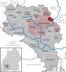
Dauchingen (Dauchingen)
- municipality in Germany
Dauchingen is a charming municipality in the Schwarzwald-Baar-Kreis in Baden-Württemberg, Germany. It is surrounded by beautiful landscapes that are ideal for hiking enthusiasts. Here are some highlights you can expect when hiking in and around Dauchingen:
-
Scenic Trails: The region offers a variety of hiking trails ranging from easy walks suitable for families to more challenging hikes for experienced adventurers. Trails often feature stunning views of the Black Forest and the surrounding countryside.
-
Nature: The area boasts lush forests, rolling hills, and picturesque meadows. Hikers can enjoy the tranquility of nature, with opportunities to see local wildlife and diverse flora.
-
Cultural and Historical Sites: While hiking, you might come across local historical landmarks or traditional villages, giving you a taste of the area’s rich history and culture.
-
Accessibility: Dauchingen is well-connected to several longer-distance trails in the region, making it a great starting point for exploring the larger hiking network, including paths that lead into the Black Forest itself.
-
Local Amenities: After a day of hiking, you can enjoy local restaurants and cafes in Dauchingen, where you can taste regional dishes and recharge before your next adventure.
-
Cycling and Other Activities: Besides hiking, the area is also great for cycling. Combining hiking with biking can provide varied experiences of the beautiful landscape.
If you plan to hike in Dauchingen, make sure to check local hiking maps or apps for trail information, and always respect nature by following the Leave No Trace principles. Happy hiking!
- Country:

- Postal Code: 78083
- Local Dialing Code: 07720
- Licence Plate Code: VS
- Coordinates: 48° 5' 25" N, 8° 33' 7" E


- GPS tracks (wikiloc): [Link]
- AboveSeaLevel: 732 м m
- Area: 10.04 sq km
- Population: 3702
- Web site: http://www.dauchingen.de/
- Wikipedia en: wiki(en)
- Wikipedia: wiki(de)
- Wikidata storage: Wikidata: Q81442
- Wikipedia Commons Category: [Link]
- Freebase ID: [/m/02p_x2r]
- GeoNames ID: Alt: [6555821]
- VIAF ID: Alt: [235212216]
- OSM relation ID: [1242303]
- GND ID: Alt: [4468928-7]
- archINFORM location ID: [13726]
- Historical Gazetteer (GOV) ID: [DAUGENJN48GC]
- German municipality key: 08326010

