Devay (Devay)

- commune in Nièvre, France
- Country:

- Postal Code: 58300
- Coordinates: 46° 48' 21" N, 3° 32' 57" E


- GPS tracks (wikiloc): [Link]
- Area: 12.08 sq km
- Population: 509
- Wikipedia en: wiki(en)
- Wikipedia: wiki(fr)
- Wikidata storage: Wikidata: Q664940
- Wikipedia Commons Category: [Link]
- Freebase ID: [/m/03qfckc]
- GeoNames ID: Alt: [6450017]
- SIREN number: [215800962]
- BnF ID: [15266361x]
- INSEE municipality code: 58096
Shares border with regions:

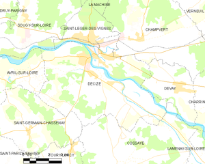
Decize
- commune in Nièvre, France
- Country:
- Postal Code: 58300
- Coordinates: 46° 49' 45" N, 3° 27' 41" E
- GPS tracks (wikiloc): [Link]
- Area: 48.22 sq km
- Population: 5623
- Web site: [Link]
Charrin
- commune in Nièvre, France
- Country:
- Postal Code: 58300
- Coordinates: 46° 47' 19" N, 3° 35' 54" E
- GPS tracks (wikiloc): [Link]
- Area: 26.3 sq km
- Population: 604


Champvert
- commune in Nièvre, France
- Country:
- Postal Code: 58300
- Coordinates: 46° 50' 26" N, 3° 30' 41" E
- GPS tracks (wikiloc): [Link]
- Area: 46.12 sq km
- Population: 824

Cossaye
- commune in Nièvre, France
- Country:
- Postal Code: 58300
- Coordinates: 46° 44' 55" N, 3° 29' 4" E
- GPS tracks (wikiloc): [Link]
- Area: 51.17 sq km
- Population: 742