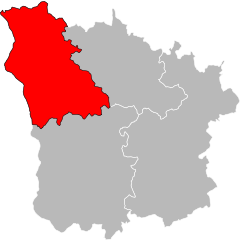
arrondissement of Nevers (arrondissement de Nevers)

- arrondissement of France
- Country:

- Capital: Nevers
- Coordinates: 46° 55' 0" N, 3° 20' 0" E


- GPS tracks (wikiloc): [Link]
- Area: 2020 sq km
- Population: 117173
- Wikipedia en: wiki(en)
- Wikipedia: wiki(fr)
- Wikidata storage: Wikidata: Q263441
- Freebase ID: [/m/0955sn]
- GeoNames ID: Alt: [2990473]
- INSEE arrondissement code: [583]
- GNS Unique Feature ID: -1454957
Includes regions:

canton of Saint-Benin-d'Azy
- canton of France (until March 2015)
- Country:
- Capital: Saint-Benin-d'Azy
- Coordinates: 46° 58' 55" N, 3° 25' 54" E
- GPS tracks (wikiloc): [Link]
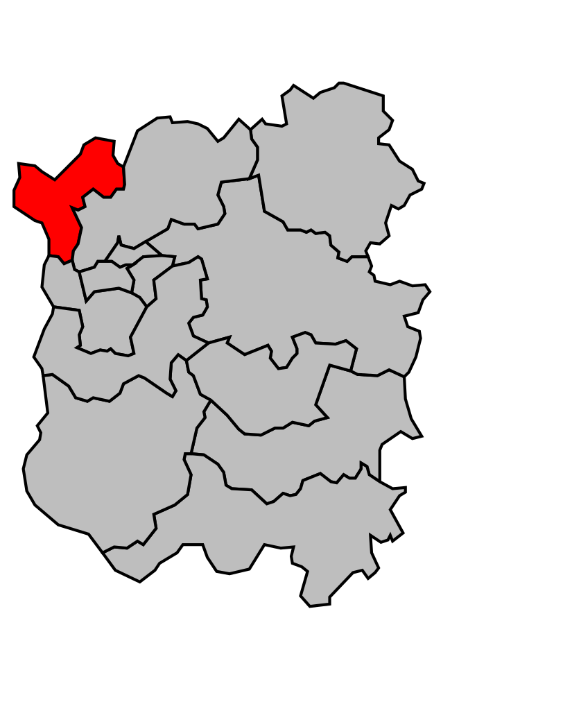
canton of Pougues-les-Eaux
- canton of France (until March 2015)
- Country:
- Capital: Pougues-les-Eaux
- Coordinates: 47° 3' 46" N, 3° 5' 36" E
- GPS tracks (wikiloc): [Link]


canton of Saint-Saulge
- canton of France (until March 2015)
- Country:
- Capital: Saint-Saulge
- Coordinates: 47° 5' 51" N, 3° 29' 39" E
- GPS tracks (wikiloc): [Link]


canton of Saint-Pierre-le-Moûtier
- canton of France
- Country:
- Capital: Saint-Pierre-le-Moûtier
- Coordinates: 46° 48' 27" N, 3° 9' 8" E
- GPS tracks (wikiloc): [Link]
- Population: 10307


canton of Imphy
- canton of France
- Country:
- Capital: Imphy
- Coordinates: 46° 55' 29" N, 3° 10' 51" E
- GPS tracks (wikiloc): [Link]
- Population: 10473


canton of Guérigny
- canton of France
- Country:
- Capital: Guérigny
- Coordinates: 47° 4' 38" N, 3° 14' 15" E
- GPS tracks (wikiloc): [Link]
- Population: 14476

canton of La Machine
- canton of France (until March 2015)
- Country:
- Capital: La Machine
- Coordinates: 46° 52' 28" N, 3° 24' 4" E
- GPS tracks (wikiloc): [Link]

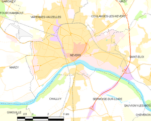
Nevers
- commune in Nièvre, France
- Country:
- Postal Code: 58000
- Coordinates: 46° 59' 33" N, 3° 9' 24" E
- GPS tracks (wikiloc): [Link]
- AboveSeaLevel: 180 м m
- Area: 17.33 sq km
- Population: 34228
- Web site: [Link]


canton of Decize
- canton of France
- Country:
- Capital: Decize
- Coordinates: 46° 49' 27" N, 3° 27' 0" E
- GPS tracks (wikiloc): [Link]
- Population: 11304
Shares border with regions:

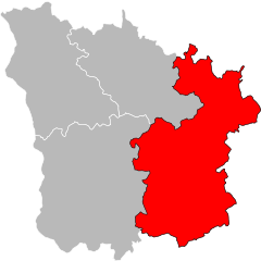
arrondissement of Saint-Amand-Montrond
- arrondissement of France
- Country:
- Capital: Saint-Amand-Montrond
- Coordinates: 46° 45' 0" N, 2° 30' 0" E
- GPS tracks (wikiloc): [Link]
- Area: 2670 sq km
- Population: 64490


arrondissement of Bourges
- arrondissement of France
- Country:
- Capital: Bourges
- Coordinates: 47° 15' 0" N, 2° 25' 0" E
- GPS tracks (wikiloc): [Link]
- Area: 2798 sq km
- Population: 173577


arrondissement of Clamecy
- arrondissement of France
- Country:
- Capital: Clamecy
- Coordinates: 47° 20' 0" N, 3° 40' 0" E
- GPS tracks (wikiloc): [Link]
- Population: 21597
arrondissement of Cosne-Cours-sur-Loire
- arrondissement of France
- Country:
- Capital: Cosne-Cours-sur-Loire
- Coordinates: 47° 20' 0" N, 3° 10' 0" E
- GPS tracks (wikiloc): [Link]
- Area: 1403.33 sq km
- Population: 44367

arrondissement of Château-Chinon
- arrondissement of France
- Country:
- Capital: Château-Chinon (Ville)
- Coordinates: 47° 0' 0" N, 3° 50' 0" E
- GPS tracks (wikiloc): [Link]
- Area: 1929 sq km
- Population: 28610