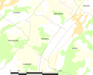
Doissin (Doissin)

- commune in Isère, France
 Hiking in Doissin
Doissin, located in the Auvergne-Rhône-Alpes region of France, is a beautiful spot for hiking enthusiasts. The area is characterized by its picturesque landscapes, including rolling hills, forests, and scenic viewpoints.
Hiking Trails
There are several marked hiking trails in and around Doissin, ranging from easy walks suitable for families to more challenging routes for experienced hikers. The trails typically offer stunning views of the surrounding countryside and opportunities to explore local flora and fauna.
Recommended Routes
-
Les Chemins de Doissin: A network of trails that can be combined for longer hikes. Some paths lead to beautiful vantage points where you can see the Alps in the distance on clear days.
-
Les Sentiers de la Forêt: This trail takes you through dense forests, perfect for those who enjoy shaded paths and the sounds of nature.
-
La Boucle du Saut: A moderate loop that provides access to a small waterfall and scenic picnic spots.
Preparation
-
What to Bring: Always wear sturdy hiking boots and bring plenty of water, snacks, a map or GPS device, and a first-aid kit. It's also wise to check the weather and dress accordingly.
-
Wildlife: Keep an eye out for local wildlife, including birds and various small mammals. Remember to respect their habitat and maintain a safe distance.
Local Tips
- Best Time to Visit: The best seasons for hiking in Doissin are spring and autumn, when temperatures are comfortable and the scenery is particularly beautiful.
- Safety: Make sure to inform someone of your hiking plans, especially if you’re venturing into less populated areas.
Conclusion
Whether you're a seasoned hiker or a beginner, Doissin offers a variety of trails that allow you to enjoy the natural beauty of the region. Always practice Leave No Trace principles to help preserve the area for future hikers!
- Country:

- Postal Code: 38730
- Coordinates: 45° 29' 59" N, 5° 25' 25" E


- GPS tracks (wikiloc): [Link]
- Area: 8.45 sq km
- Population: 891
- Web site: http://www.doissin.fr
- Wikipedia en: wiki(en)
- Wikipedia: wiki(fr)
- Wikidata storage: Wikidata: Q1003921
- Wikipedia Commons Category: [Link]
- Freebase ID: [/m/03nvhr1]
- GeoNames ID: Alt: [6433188]
- SIREN number: [213801475]
- BnF ID: [15257969c]
- INSEE municipality code: 38147
Shares border with regions:

Blandin
- commune in Isère, France
Hiking in Blandin
Blandin, located in Minnesota, is known for its beautiful landscapes and outdoor recreational opportunities, including hiking. The area offers a variety of trails suited for different skill levels and preferences, ranging from leisurely walks to more challenging hikes....
- Country:
- Postal Code: 38730
- Coordinates: 45° 28' 11" N, 5° 26' 53" E
- GPS tracks (wikiloc): [Link]
- Area: 4.26 sq km
- Population: 141

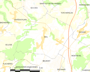
Biol
- commune in Isère, France
Hiking in Biol
Biol is a charming village located in the Isère department of the Auvergne-Rhône-Alpes region in southeastern France. It's a great destination for hikers due to its proximity to the beautiful Vercors massif and the Chartreuse mountain range. Here are some highlights and tips for hiking in and around Biol:...
- Country:
- Postal Code: 38690
- Coordinates: 45° 29' 30" N, 5° 23' 7" E
- GPS tracks (wikiloc): [Link]
- Area: 15.51 sq km
- Population: 1398
- Web site: [Link]

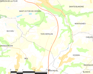
Torchefelon
- commune in Isère, France
Hiking in Torchefelon
Torchefelon is a beautiful destination for hiking, located in the Savoie region of the French Alps. The area is known for its stunning landscapes, with a mix of rugged mountain terrain, lush valleys, and alpine meadows. Here are some highlights and tips for hiking in Torchefelon:...
- Country:
- Postal Code: 38690
- Coordinates: 45° 31' 13" N, 5° 24' 1" E
- GPS tracks (wikiloc): [Link]
- Area: 8.68 sq km
- Population: 708
- Web site: [Link]


Panissage
- commune in Isère, France
Hiking in Panissage
I'm sorry, but it seems like there isn't a well-known hiking destination specifically called "Panissage." It's possible that it might be a lesser-known area, a local spot, or perhaps a misspelling of another location....
- Country:
- Postal Code: 38730
- Coordinates: 45° 29' 39" N, 5° 27' 47" E
- GPS tracks (wikiloc): [Link]
- Area: 4.88 sq km
- Population: 448


Montrevel
- commune in Isère, France
Hiking in Montrevel
Montrevel is located in the Isère department of the Auvergne-Rhône-Alpes region in southeastern France. It is a beautiful area for hiking, known for its diverse landscapes that combine mountains, valleys, forests, and rivers. Here are some highlights and tips for hiking in the Montrevel area:...
- Country:
- Postal Code: 38690
- Coordinates: 45° 28' 44" N, 5° 24' 8" E
- GPS tracks (wikiloc): [Link]
- Area: 9.37 sq km
- Population: 461
- Web site: [Link]


Montagnieu
- commune in Isère, France
Hiking in Montagnieu
Montagnieu, located in the department of Isère in the Auvergne-Rhône-Alpes region of France, offers a variety of hiking options that showcase the natural beauty of the surrounding landscapes. Here are some key points about hiking in this area:...
- Country:
- Postal Code: 38110
- Coordinates: 45° 31' 27" N, 5° 27' 9" E
- GPS tracks (wikiloc): [Link]
- Area: 8.83 sq km
- Population: 1023

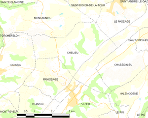
Chélieu
- commune in Isère, France
Hiking in Chélieu
Chélieu, located in the Isère department of the Auvergne-Rhône-Alpes region in France, offers beautiful landscapes and opportunities for hiking enthusiasts. The area is characterized by its stunning mountainous terrain, with the Chartreuse Mountains nearby providing a range of trails suitable for different skill levels....
- Country:
- Postal Code: 38730
- Coordinates: 45° 30' 44" N, 5° 28' 33" E
- GPS tracks (wikiloc): [Link]
- AboveSeaLevel: 607 м m
- Area: 10.13 sq km
- Population: 674
- Web site: [Link]