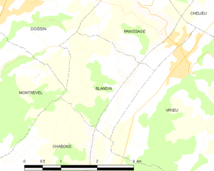
Blandin (Blandin)
- commune in Isère, France
Blandin, located in Minnesota, is known for its beautiful landscapes and outdoor recreational opportunities, including hiking. The area offers a variety of trails suited for different skill levels and preferences, ranging from leisurely walks to more challenging hikes.
Key Hiking Areas:
-
Chippewa National Forest: This expansive forest features numerous trails, many of which traverse through beautiful wooded areas, wetlands, and along scenic lakes. The trails here cater to both casual hikers and those seeking a more rigorous adventure.
-
Itasca State Park: Located not too far from Blandin, this state park is home to the headwaters of the Mississippi River. It offers a network of hiking trails that vary in difficulty and provide spectacular views of the river and surrounding wildlife.
-
Blandin Paper Company Land: The Blandin Paper Company land may also have access to trails for outdoor enthusiasts, but ensure you check any regulations regarding public access and permitted activities.
Tips for Hiking in Blandin:
-
Trail Conditions: Always check the trail conditions before you head out, especially in the spring and fall when trails may be muddy or icy.
-
Wildlife Considerations: Blandin and its surrounding areas are home to various wildlife. Be respectful ofNature and keep a safe distance.
-
Preparation: Depending on the length and difficulty of your hike, ensure you have plenty of water, snacks, a map, and appropriate gear. Dress in layers to adapt to changing weather conditions.
-
Leave No Trace: Follow the principles of Leave No Trace to minimize your impact on the environment.
Overall, hiking in the Blandin area offers a fantastic opportunity to enjoy Minnesota's natural beauty. Whether you're looking for a peaceful walk in the woods or a challenging trek, there's something for every hiking enthusiast.
- Country:

- Postal Code: 38730
- Coordinates: 45° 28' 11" N, 5° 26' 53" E


- GPS tracks (wikiloc): [Link]
- Area: 4.26 sq km
- Population: 141
- Wikipedia en: wiki(en)
- Wikipedia: wiki(fr)
- Wikidata storage: Wikidata: Q1003966
- Wikipedia Commons Category: [Link]
- Freebase ID: [/m/03g_6_4]
- GeoNames ID: Alt: [6448731]
- SIREN number: [213800477]
- BnF ID: [15257876c]
- INSEE municipality code: 38047
Shares border with regions:


Châbons
- commune in Isère, France
Châbons is a charming town located in the Isère department of the Auvergne-Rhône-Alpes region in southeastern France. It's surrounded by beautiful landscapes and offers various hiking opportunities suitable for different levels of experience. Here are some highlights regarding hiking in and around Châbons:...
- Country:

- Postal Code: 38690
- Coordinates: 45° 26' 38" N, 5° 25' 51" E


- GPS tracks (wikiloc): [Link]
- Area: 18.14 sq km
- Population: 2098
- Web site: [Link]


Doissin
- commune in Isère, France
Doissin, located in the Auvergne-Rhône-Alpes region of France, is a beautiful spot for hiking enthusiasts. The area is characterized by its picturesque landscapes, including rolling hills, forests, and scenic viewpoints....
- Country:

- Postal Code: 38730
- Coordinates: 45° 29' 59" N, 5° 25' 25" E


- GPS tracks (wikiloc): [Link]
- Area: 8.45 sq km
- Population: 891
- Web site: [Link]


Virieu
- commune in Isère, France
Virieu is a charming commune located in the Auvergne-Rhône-Alpes region of France. It's surrounded by picturesque landscapes, making it an excellent destination for hiking enthusiasts. Here are some key aspects of hiking in Virieu:...
- Country:

- Postal Code: 38730
- Coordinates: 45° 29' 8" N, 5° 28' 32" E


- GPS tracks (wikiloc): [Link]
- Area: 11.38 sq km
- Population: 1110
- Web site: [Link]


Panissage
- commune in Isère, France
I'm sorry, but it seems like there isn't a well-known hiking destination specifically called "Panissage." It's possible that it might be a lesser-known area, a local spot, or perhaps a misspelling of another location....
- Country:

- Postal Code: 38730
- Coordinates: 45° 29' 39" N, 5° 27' 47" E


- GPS tracks (wikiloc): [Link]
- Area: 4.88 sq km
- Population: 448


Montrevel
- commune in Isère, France
Montrevel is located in the Isère department of the Auvergne-Rhône-Alpes region in southeastern France. It is a beautiful area for hiking, known for its diverse landscapes that combine mountains, valleys, forests, and rivers. Here are some highlights and tips for hiking in the Montrevel area:...
- Country:

- Postal Code: 38690
- Coordinates: 45° 28' 44" N, 5° 24' 8" E


- GPS tracks (wikiloc): [Link]
- Area: 9.37 sq km
- Population: 461
- Web site: [Link]

