Panissage (Panissage)

- commune in Isère, France
 Hiking in Panissage
I'm sorry, but it seems like there isn't a well-known hiking destination specifically called "Panissage." It's possible that it might be a lesser-known area, a local spot, or perhaps a misspelling of another location.
If you meant a different location or if Panissage refers to a specific area that’s not widely documented, please provide more details or clarify, and I would be happy to assist you with information on hiking opportunities in that region!
- Country:

- Postal Code: 38730
- Coordinates: 45° 29' 39" N, 5° 27' 47" E


- GPS tracks (wikiloc): [Link]
- Area: 4.88 sq km
- Population: 448
- Wikipedia en: wiki(en)
- Wikipedia: wiki(fr)
- Wikidata storage: Wikidata: Q587689
- Wikipedia Commons Category: [Link]
- Freebase ID: [/m/03nvgh5]
- GeoNames ID: Alt: [6433278]
- SIREN number: [213802937]
- BnF ID: [152581055]
- INSEE municipality code: 38293
Shares border with regions:


Doissin
- commune in Isère, France
Hiking in Doissin
Doissin, located in the Auvergne-Rhône-Alpes region of France, is a beautiful spot for hiking enthusiasts. The area is characterized by its picturesque landscapes, including rolling hills, forests, and scenic viewpoints....
- Country:
- Postal Code: 38730
- Coordinates: 45° 29' 59" N, 5° 25' 25" E
- GPS tracks (wikiloc): [Link]
- Area: 8.45 sq km
- Population: 891
- Web site: [Link]

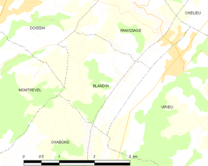
Blandin
- commune in Isère, France
Hiking in Blandin
Blandin, located in Minnesota, is known for its beautiful landscapes and outdoor recreational opportunities, including hiking. The area offers a variety of trails suited for different skill levels and preferences, ranging from leisurely walks to more challenging hikes....
- Country:
- Postal Code: 38730
- Coordinates: 45° 28' 11" N, 5° 26' 53" E
- GPS tracks (wikiloc): [Link]
- Area: 4.26 sq km
- Population: 141


Virieu
- commune in Isère, France
Hiking in Virieu
Virieu is a charming commune located in the Auvergne-Rhône-Alpes region of France. It's surrounded by picturesque landscapes, making it an excellent destination for hiking enthusiasts. Here are some key aspects of hiking in Virieu:...
- Country:
- Postal Code: 38730
- Coordinates: 45° 29' 8" N, 5° 28' 32" E
- GPS tracks (wikiloc): [Link]
- Area: 11.38 sq km
- Population: 1110
- Web site: [Link]

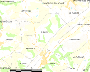
Chélieu
- commune in Isère, France
Hiking in Chélieu
Chélieu, located in the Isère department of the Auvergne-Rhône-Alpes region in France, offers beautiful landscapes and opportunities for hiking enthusiasts. The area is characterized by its stunning mountainous terrain, with the Chartreuse Mountains nearby providing a range of trails suitable for different skill levels....
- Country:
- Postal Code: 38730
- Coordinates: 45° 30' 44" N, 5° 28' 33" E
- GPS tracks (wikiloc): [Link]
- AboveSeaLevel: 607 м m
- Area: 10.13 sq km
- Population: 674
- Web site: [Link]