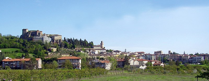
Dovadola (Dovadola)
.svg)
- Italian comune
 Hiking in Dovadola
Dovadola is a charming village in the Emilia-Romagna region of Italy, nestled in the picturesque Apennine Mountains. It offers a wonderful experience for hikers looking to explore the beauty of the Italian countryside.
Hiking Trails
-
Monte Busca: This is one of the most popular hiking areas near Dovadola. The trail to Monte Busca provides stunning panoramic views of the surrounding landscape and is suitable for various skill levels. The hike typically takes about 2-3 hours round trip.
-
Sentiero degli Dei: Known as the "Path of the Gods," this scenic trail offers beautiful views and a chance to immerse yourself in nature. It may be a bit challenging, so be prepared with adequate gear and water.
-
Parks and Nature Reserves: The nearby Casentino Forests, Monte Falterona, and Campigna National Park offer numerous trails ranging from easy walks to challenging hikes. You can find more demanding routes that lead to higher altitudes, providing breathtaking vistas.
Tips for Hiking in Dovadola
-
Best Time to Hike: Late spring (May to June) and early autumn (September to October) are ideal times for hiking, with mild temperatures and fewer crowds.
-
Gear Up: Ensure you have appropriate hiking gear, including sturdy footwear, a backpack, water, snacks, and weather-appropriate clothing.
-
Local Guides: Consider hiring a local guide who knows the trails well if you're unfamiliar with the area.
-
Safety First: Always check the weather before heading out, and let someone know your planned route and expected return time.
-
Respect Nature: Stay on marked trails, and follow the Leave No Trace principles to preserve the natural environment.
Dovadola’s serene landscapes and trails offer a wonderful hiking experience that highlights the beauty of Italy's Apennine region. Whether you're a beginner or an experienced hiker, you'll find trails suited to your level, alongside opportunities to enjoy the local culture and cuisine.
- Country:

- Postal Code: 47013
- Local Dialing Code: 0543
- Licence Plate Code: FC
- Coordinates: 44° 7' 0" N, 11° 53' 0" E


- GPS tracks (wikiloc): [Link]
- AboveSeaLevel: 143 м m
- Area: 38.97 sq km
- Population: 1581
- Web site: http://www.comune.dovadola.fc.it/
- Wikipedia en: wiki(en)
- Wikipedia: wiki(it)
- Wikidata storage: Wikidata: Q99939
- Wikipedia Commons Category: [Link]
- Freebase ID: [/m/0gkly4]
- GeoNames ID: Alt: [6536755]
- VIAF ID: Alt: [246982232]
- OSM relation ID: [42878]
- MusicBrainz area ID: [1fd495db-c801-48bd-9afa-484776e8c95b]
- ISTAT ID: 040011
- Italian cadastre code: D357
Shares border with regions:

Castrocaro Terme e Terra del Sole
- Italian comune
Hiking in Castrocaro Terme e Terra del Sole
Castrocaro Terme e Terra del Sole, located in the Emilia-Romagna region of Italy, offers a unique blend of natural beauty, historical significance, and wellness. Here are some highlights of hiking in this beautiful area:...
- Country:
- Postal Code: 47011
- Local Dialing Code: 0543
- Licence Plate Code: FC
- Coordinates: 44° 11' 3" N, 11° 56' 38" E
- GPS tracks (wikiloc): [Link]
- AboveSeaLevel: 68 м m
- Area: 38.95 sq km
- Population: 6350
- Web site: [Link]


Modigliana
- Italian comune
Hiking in Modigliana
Modigliana, nestled in the Apennine hills in the Emilia-Romagna region of Italy, offers a scenic landscape perfect for hiking enthusiasts. The area is characterized by rolling hills, vineyards, and olive groves, providing a peaceful and picturesque environment....
- Country:
- Postal Code: 47015
- Local Dialing Code: 0546
- Licence Plate Code: FC
- Coordinates: 44° 10' 0" N, 11° 48' 0" E
- GPS tracks (wikiloc): [Link]
- AboveSeaLevel: 185 м m
- Area: 101.17 sq km
- Population: 4482
- Web site: [Link]


Predappio
- Italian comune
Hiking in Predappio
Predappio, located in the Emilia-Romagna region of Italy, is surrounded by beautiful countryside and offers various hiking opportunities. The area is characterized by rolling hills, wooded areas, and stunning views, making it a great destination for outdoor activities....
- Country:
- Postal Code: 47016
- Local Dialing Code: 0543
- Licence Plate Code: FC
- Coordinates: 44° 6' 15" N, 11° 59' 6" E
- GPS tracks (wikiloc): [Link]
- AboveSeaLevel: 133 м m
- Area: 91.39 sq km
- Population: 6287
- Web site: [Link]


Rocca San Casciano
- Italian comune
Hiking in Rocca San Casciano
Rocca San Casciano, located in the Emilia-Romagna region of Italy, is a charming village with beautiful landscapes perfect for hiking enthusiasts. The area is characterized by rolling hills, lush forests, and scenic views, making it an ideal destination for those looking to explore the outdoors....
- Country:
- Postal Code: 47017
- Local Dialing Code: 0543
- Licence Plate Code: FC
- Coordinates: 44° 4' 0" N, 11° 51' 0" E
- GPS tracks (wikiloc): [Link]
- AboveSeaLevel: 210 м m
- Area: 50.56 sq km
- Population: 1874
- Web site: [Link]