Modigliana (Modigliana)
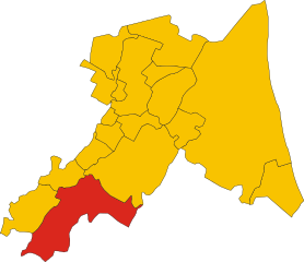
- Italian comune
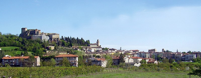
Modigliana, nestled in the Apennine hills in the Emilia-Romagna region of Italy, offers a scenic landscape perfect for hiking enthusiasts. The area is characterized by rolling hills, vineyards, and olive groves, providing a peaceful and picturesque environment.
Hiking Trails:
-
Trail through the Sasso di Simone: This trail takes you through diverse landscapes with captivating views of the surrounding hills. It's suitable for various skill levels, and the flora and fauna can be quite fascinating.
-
Via degli Dei: While this famous trail doesn't pass directly through Modigliana, it's easily accessible. It connects Bologna and Florence, running through the Apennines with stunning views and rich historical significance.
-
Local Trails: There are numerous smaller trails around Modigliana that allow hikers to explore the charming countryside, small villages, and historical sites. These paths often wind through vineyards and olive orchards, showcasing the region's rural beauty.
Best Times to Hike:
- Spring (March to June): Ideal for pleasant temperatures and blooming landscapes. The trails are lively with wildflowers, and the weather is perfect for hiking.
- Autumn (September to November): Offers stunning autumn foliage and a chance to enjoy the local harvest season, especially in vineyards.
What to Expect:
- Views: Expect breathtaking panoramic views of the hills and valleys, especially from higher elevations.
- Wildlife: You may spot various wildlife, including birds and small mammals.
- Cultural Interactions: Hikers can also experience the local culture, perhaps stopping by a osteria for traditional Italian cuisine.
Tips for Hiking in Modigliana:
- Footwear: Wear sturdy hiking boots, as some trails can be rocky or steep.
- Map and Guidance: Consider bringing a map or using a hiking app to help navigate the trails, especially if you're exploring lesser-known paths.
- Hydration and Snacks: Carry enough water and snacks, especially on longer hikes.
- Respect Nature: Follow the Leave No Trace principles to preserve the natural beauty of the area.
Exploring Modigliana through hiking is a rewarding experience, combining physical activity with an appreciation of nature and local culture.
- Country:

- Postal Code: 47015
- Local Dialing Code: 0546
- Licence Plate Code: FC
- Coordinates: 44° 10' 0" N, 11° 48' 0" E


- GPS tracks (wikiloc): [Link]
- AboveSeaLevel: 185 м m
- Area: 101.17 sq km
- Population: 4482
- Web site: http://www.comune.modigliana.fc.it
- Wikipedia en: wiki(en)
- Wikipedia: wiki(it)
- Wikidata storage: Wikidata: Q99947
- Wikipedia Commons Category: [Link]
- Freebase ID: [/m/0gkm2v]
- GeoNames ID: Alt: [6541046]
- BnF ID: [121612746]
- VIAF ID: Alt: [168302007]
- OSM relation ID: [42876]
- GND ID: Alt: [4238533-7]
- WOEID: [718434]
- UN/LOCODE: [ITMDG]
- ISTAT ID: 040022
- Italian cadastre code: F259
Shares border with regions:


Brisighella
- Italian comune
Brisighella is a charming medieval town located in the Emilia-Romagna region of Italy, surrounded by beautiful hills and nature, making it a great destination for hiking enthusiasts. Here are some highlights and tips for hiking in and around Brisighella:...
- Country:

- Postal Code: 48013
- Local Dialing Code: 0546
- Licence Plate Code: RA
- Coordinates: 44° 13' 0" N, 11° 46' 0" E


- GPS tracks (wikiloc): [Link]
- AboveSeaLevel: 115 м m
- Area: 194.33 sq km
- Population: 7579
- Web site: [Link]


Marradi
- Italian comune
Marradi is a charming town located in the Tuscany region of Italy, surrounded by beautiful landscapes, making it an excellent destination for hiking enthusiasts. The area is characterized by its rolling hills, lush forests, and scenic views, providing a variety of trails for both novice and experienced hikers. Here are some key points about hiking in Marradi:...
- Country:

- Postal Code: 50034
- Local Dialing Code: 055
- Licence Plate Code: FI
- Coordinates: 44° 5' 0" N, 11° 37' 0" E


- GPS tracks (wikiloc): [Link]
- AboveSeaLevel: 328 м m
- Area: 154.07 sq km
- Population: 3062
- Web site: [Link]


Castrocaro Terme e Terra del Sole
- Italian comune
 Hiking in Castrocaro Terme e Terra del Sole
Castrocaro Terme e Terra del Sole, located in the Emilia-Romagna region of Italy, offers a unique blend of natural beauty, historical significance, and wellness. Here are some highlights of hiking in this beautiful area:...
- Country:

- Postal Code: 47011
- Local Dialing Code: 0543
- Licence Plate Code: FC
- Coordinates: 44° 11' 3" N, 11° 56' 38" E


- GPS tracks (wikiloc): [Link]
- AboveSeaLevel: 68 м m
- Area: 38.95 sq km
- Population: 6350
- Web site: [Link]


Dovadola
- Italian comune
Dovadola is a charming village in the Emilia-Romagna region of Italy, nestled in the picturesque Apennine Mountains. It offers a wonderful experience for hikers looking to explore the beauty of the Italian countryside....
- Country:

- Postal Code: 47013
- Local Dialing Code: 0543
- Licence Plate Code: FC
- Coordinates: 44° 7' 0" N, 11° 53' 0" E


- GPS tracks (wikiloc): [Link]
- AboveSeaLevel: 143 м m
- Area: 38.97 sq km
- Population: 1581
- Web site: [Link]


Rocca San Casciano
- Italian comune
Rocca San Casciano, located in the Emilia-Romagna region of Italy, is a charming village with beautiful landscapes perfect for hiking enthusiasts. The area is characterized by rolling hills, lush forests, and scenic views, making it an ideal destination for those looking to explore the outdoors....
- Country:

- Postal Code: 47017
- Local Dialing Code: 0543
- Licence Plate Code: FC
- Coordinates: 44° 4' 0" N, 11° 51' 0" E


- GPS tracks (wikiloc): [Link]
- AboveSeaLevel: 210 м m
- Area: 50.56 sq km
- Population: 1874
- Web site: [Link]


Tredozio
- Italian comune
Tredozio is a charming village located in the Emilia-Romagna region of Italy, nestled in the scenic Apennine Mountains. It provides a beautiful backdrop for hiking enthusiasts, thanks to its diverse landscapes, rich flora and fauna, and cultural heritage. Here are some key points and trails to consider when hiking in and around Tredozio:...
- Country:

- Postal Code: 47019
- Local Dialing Code: 0546
- Licence Plate Code: FC
- Coordinates: 44° 5' 0" N, 11° 45' 0" E


- GPS tracks (wikiloc): [Link]
- AboveSeaLevel: 334 м m
- Area: 62.2 sq km
- Population: 1165
- Web site: [Link]
