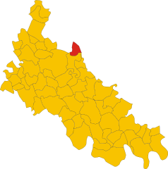
Dovera (Dovera)
.svg)
- Italian comune
 Hiking in Dovera
Dovera, a small town in Italy's Lombardy region, offers a unique opportunity for hikers, particularly those interested in exploring the natural beauty of the surrounding areas. While Dovera itself is not a major hiking destination, it's conveniently situated near several natural parks and hiking trails. Here are some points to consider if you're looking to hike in and around Dovera:
Nearby Hiking Opportunities
-
Parco Regionale Adda Nord: Located just a short drive from Dovera, this regional park boasts numerous trails along the Adda River. Hikers can enjoy a range of routes, from easy walks to more challenging hikes that allow you to explore the park’s diverse flora and fauna.
-
Parco della Vettabbia: This park is another nearby area perfect for hiking, featuring well-marked trails that take you through beautiful landscapes and alongside charming rivers.
-
Oglio River Park: About an hour from Dovera, this park offers scenic trails along the Oglio River, with opportunities for wildlife observation and photography.
Hiking Tips
- Trail Maps: Always carry a map or download trail apps to navigate the routes accurately, as signage may not always be reliable.
- Local Weather: Check the weather forecast before heading out, as conditions can change quickly in the region.
- What to Bring: Pack essentials including water, snacks, a first-aid kit, a fully charged phone, and a flashlight if you anticipate being out during low-light conditions.
- Respect Nature: Follow Leave No Trace principles to preserve the natural beauty of the trails.
Cultural Aspects
Hiking in the region provides a chance to engage with local culture. Consider stopping by local towns to enjoy authentic Italian cuisine and interact with residents, who can often provide tips on hidden gems and lesser-known trails.
Whether you are looking for a leisurely walk or a more strenuous hike, the areas surrounding Dovera offer plenty of options for outdoor enthusiasts.
- Country:

- Postal Code: 26010
- Local Dialing Code: 0373
- Licence Plate Code: CR
- Coordinates: 45° 22' 0" N, 9° 32' 0" E


- GPS tracks (wikiloc): [Link]
- AboveSeaLevel: 73 м m
- Area: 20.65 sq km
- Population: 3853
- Web site: http://www.comune.dovera.cr.it
- Wikipedia en: wiki(en)
- Wikipedia: wiki(it)
- Wikidata storage: Wikidata: Q42167
- Wikipedia Commons Category: [Link]
- Freebase ID: [/m/0gjyyy]
- GeoNames ID: Alt: [6537212]
- VIAF ID: Alt: [150261560]
- OSM relation ID: [44767]
- UN/LOCODE: [ITDVR]
- ISTAT ID: 019041
- Italian cadastre code: D358
Shares border with regions:


Corte Palasio
- Italian comune
Hiking in Corte Palasio
Corte Palasio, located in northern Italy near the Po River, is a lesser-known destination for hiking compared to other regions in Italy, such as the Dolomites or the Alps. However, it offers some scenic views and peaceful, rural landscapes that can be appealing for those looking for a quiet hiking experience away from the busy tourist spots....
- Country:
- Postal Code: 26834
- Local Dialing Code: 0371
- Licence Plate Code: LO
- Coordinates: 45° 18' 33" N, 9° 33' 48" E
- GPS tracks (wikiloc): [Link]
- AboveSeaLevel: 69 м m
- Area: 15.68 sq km
- Population: 1546
- Web site: [Link]


Monte Cremasco
- Italian comune
Hiking in Monte Cremasco
Monte Cremasco is a lesser-known destination for hiking, located in the Lombardy region of Italy. While it may not be as famous as some of the larger mountain ranges in the country, it offers beautiful landscapes and a mix of rural and natural scenery that can be quite appealing for outdoor enthusiasts....
- Country:
- Postal Code: 26010
- Local Dialing Code: 0373
- Licence Plate Code: CR
- Coordinates: 45° 23' 0" N, 9° 34' 0" E
- GPS tracks (wikiloc): [Link]
- AboveSeaLevel: 84 м m
- Area: 2.34 sq km
- Population: 2332
- Web site: [Link]


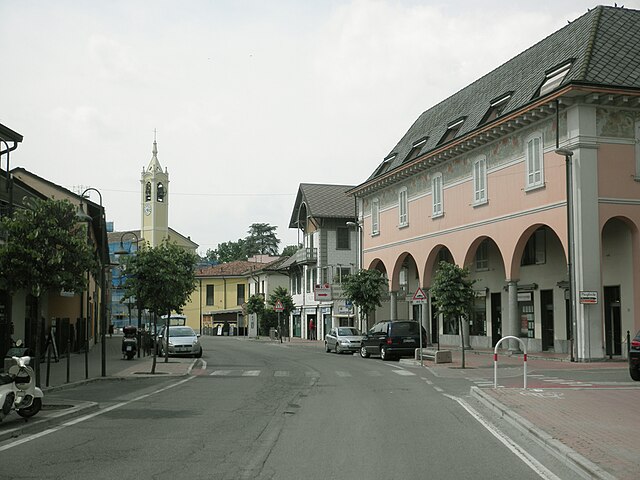
Boffalora d'Adda
- Italian comune
Hiking in Boffalora d'Adda
Boffalora d'Adda, a charming village located in the Lombardy region of Italy, is nestled along the banks of the Adda River. The area offers a variety of hiking opportunities, especially for those who enjoy exploring scenic landscapes, historical sites, and the natural beauty of the Lombardy countryside....
- Country:
- Postal Code: 26811
- Local Dialing Code: 0371
- Licence Plate Code: LO
- Coordinates: 45° 21' 39" N, 9° 29' 43" E
- GPS tracks (wikiloc): [Link]
- AboveSeaLevel: 78 м m
- Area: 8.13 sq km
- Population: 1770
- Web site: [Link]

Crespiatica
- Italian comune
Hiking in Crespiatica
Crespiatica is a small town located in the Lombardy region of Italy, and while it may not be a well-known hiking destination, the surrounding areas offer some beautiful opportunities for those looking to explore nature and enjoy outdoor activities....
- Country:
- Postal Code: 26835
- Local Dialing Code: 0371
- Licence Plate Code: LO
- Coordinates: 45° 21' 27" N, 9° 34' 34" E
- GPS tracks (wikiloc): [Link]
- AboveSeaLevel: 75 м m
- Area: 7.03 sq km
- Population: 2286
- Web site: [Link]


Pandino
- Italian comune
Hiking in Pandino
Pandino is a small town located in the Lombardy region of Italy, near the Po Valley. While it may not be as famous for hiking as some of the larger national parks or mountain ranges in Italy, there are still opportunities for outdoor activities and exploring the natural beauty of the surrounding area....
- Country:
- Postal Code: 26025
- Local Dialing Code: 0373
- Licence Plate Code: CR
- Coordinates: 45° 24' 0" N, 9° 33' 0" E
- GPS tracks (wikiloc): [Link]
- AboveSeaLevel: 85 м m
- Area: 22.3 sq km
- Population: 9015
- Web site: [Link]

Spino d’Adda
- Italian comune
Hiking in Spino d’Adda
Spino d'Adda is a picturesque town in Lombardy, Italy, located along the Adda River. It offers a variety of hiking opportunities that allow you to explore the natural beauty of the area and its surrounding landscapes. Here are some highlights and tips for hiking in Spino d'Adda:...
- Country:
- Postal Code: 26016
- Local Dialing Code: 0373
- Licence Plate Code: CR
- Coordinates: 45° 24' 0" N, 9° 30' 0" E
- GPS tracks (wikiloc): [Link]
- AboveSeaLevel: 84 м m
- Area: 20.02 sq km
- Population: 6843
- Web site: [Link]
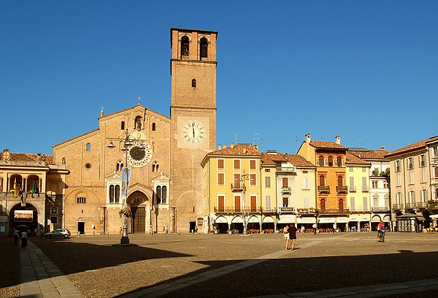

Lodi
- Italian comune
Hiking in Lodi
Lodi, a charming town in the Lombardy region of Italy, is not only rich in history and culture but also offers some great opportunities for hiking enthusiasts. Here’s an overview of hiking in and around Lodi:...
- Country:
- Postal Code: 26900
- Local Dialing Code: 0371
- Licence Plate Code: LO
- Coordinates: 45° 19' 0" N, 9° 30' 0" E
- GPS tracks (wikiloc): [Link]
- AboveSeaLevel: 87 м m
- Area: 41.38 sq km
- Population: 45212
- Web site: [Link]