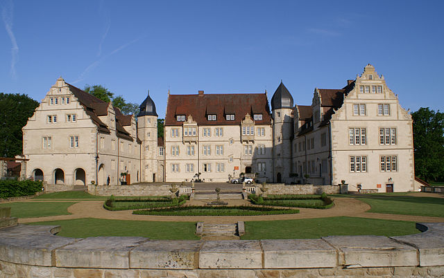
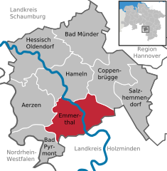
Emmerthal (Emmerthal)
- municipality of Germany
Emmerthal, located in Lower Saxony, Germany, offers a variety of hiking opportunities that cater to different skill levels and interests. The region is characterized by beautiful landscapes, including forests, rolling hills, and rivers, making it an excellent destination for outdoor enthusiasts.
Highlights of Hiking in Emmerthal:
-
Scenic Trails: Emmerthal is surrounded by picturesque areas like the Weserbergland, where you can find well-marked hiking trails that offer stunning views of the Weser River and the surrounding countryside.
-
Natural Features: The region features diverse natural landscapes, including woodlands, meadows, and rocky outcrops. Hiking here allows for a chance to see local wildlife and unique plant species.
-
Hiking Routes: There are multiple trails to choose from, ranging from short family-friendly walks to longer, more challenging hikes. Many trails are suitable for beginners, while more experienced hikers can venture into the surrounding hills for a more strenuous experience.
-
Cultural Sites: While hiking, you may encounter historical landmarks and quaint villages, giving you a glimpse into the local culture and history.
-
Accessibility: The trails in Emmerthal are generally accessible, and many starting points can be reached easily by car or public transportation.
-
Seasonal Hiking: Each season offers a unique experience. Spring and summer bring blooming flowers and lush green landscapes, while autumn showcases vibrant foliage. Winter hikes can provide a peaceful, snowy atmosphere.
Tips for Hiking in Emmerthal:
- Prepare: Always check the weather before heading out. Dress in layers and wear appropriate hiking shoes.
- Hydration and Snacks: Carry enough water and snacks to keep your energy up during your hike.
- Trail Maps: Familiarize yourself with trail maps and local guidebooks for the best routes and to ensure you stay on the paths.
- Leave No Trace: Respect nature by adhering to the Leave No Trace principles, ensuring you clean up after yourself.
- Local Guides: Consider hiring a local guide for an informative experience, especially if you're unfamiliar with the area.
Emmerthal can be a fantastic destination for both casual walkers and avid hikers, offering a mix of natural beauty and cultural experiences. Enjoy your outdoor adventure!
- Country:

- Postal Code: 31860
- Local Dialing Code: 05151; 05286; 05157; 05155
- Licence Plate Code: HM
- Coordinates: 52° 3' 0" N, 9° 23' 0" E


- GPS tracks (wikiloc): [Link]
- AboveSeaLevel: 69 м m
- Area: 115 sq km
- Population: 9882
- Web site: http://www.emmerthal.de/
- Wikipedia en: wiki(en)
- Wikipedia: wiki(de)
- Wikidata storage: Wikidata: Q534670
- Wikipedia Commons Category: [Link]
- Freebase ID: [/m/0c71yy]
- GeoNames ID: Alt: [2930484]
- BnF ID: [15090276h]
- VIAF ID: Alt: [127860725]
- OSM relation ID: [1184315]
- GND ID: Alt: [4014596-7]
- archINFORM location ID: [10752]
- Library of Congress authority ID: Alt: [n82038349]
- Historical Gazetteer (GOV) ID: [EMMHAL_W3254]
- German municipality key: 03252005
Shares border with regions:


Aerzen
- municipality of Germany
Aerzen is a picturesque town located in Lower Saxony, Germany, surrounded by beautiful landscapes that are perfect for hiking. The area features a variety of trails that cater to different experience levels, allowing both beginner and experienced hikers to enjoy the natural beauty of the region....
- Country:

- Postal Code: 31855
- Local Dialing Code: 05262; 05158; 05154
- Licence Plate Code: HM
- Coordinates: 52° 2' 58" N, 9° 15' 31" E


- GPS tracks (wikiloc): [Link]
- AboveSeaLevel: 100 м m
- Area: 105.06 sq km
- Population: 10556
- Web site: [Link]


Coppenbrügge
- municipality of Germany
Coppenbrügge, located in Lower Saxony, Germany, offers a charming backdrop for hiking enthusiasts. The region is characterized by picturesque landscapes, including rolling hills, lush forests, and scenic views. Here are some highlights and tips for hiking in and around Coppenbrügge:...
- Country:

- Postal Code: 31863
- Local Dialing Code: 05159; 05156
- Licence Plate Code: HM
- Coordinates: 52° 7' 14" N, 9° 32' 56" E


- GPS tracks (wikiloc): [Link]
- AboveSeaLevel: 131 м m
- Area: 89.81 sq km
- Population: 6998
- Web site: [Link]

