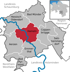
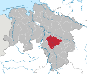
Hamelin-Pyrmont (Landkreis Hameln-Pyrmont)


- district in Lower Saxony, Germany
 Hiking in Hamelin-Pyrmont
Hameln-Pyrmont, located in the Lower Saxony region of Germany, is a fantastic destination for hikers, offering a combination of beautiful landscapes, historical sites, and diverse trails. Here’s a detailed overview of what you can expect when hiking in this area:
Natural Beauty
-
Weser Uplands: The region features the Weser Uplands, characterized by rolling hills, valleys, and the lovely Weser River. The contrasting landscapes provide stunning views, especially in the fall when the foliage changes color.
-
Protected Areas: The area includes several nature conservation sites and parks, such as the Hameln-Pyrmont Nature Park, which is home to diverse flora and fauna, making hikes here a delight for nature lovers.
-
Forests and Trails: Dense woodlands and forest trails are abundant in this region, providing a serene atmosphere and opportunities for wildlife observation.
Hiking Trails
-
The Weser-Harz-Heide Trail: This long-distance trail takes you through varied landscapes, along riverbanks, through forests, and over hills. It offers both day hikes and longer multi-day trips.
-
Weser Cycle Path: Although primarily meant for cyclists, parts of this well-maintained path are accessible for hikers, allowing you to enjoy scenic riverside walks.
-
The Teutoburg Forest: Located nearby, this area has a network of well-marked trails ranging from easy walks to more strenuous hikes. Look for the Hermannsweg, a famous long-distance hiking trail that runs through the Teutoburg Forest.
Historical Sites
As you hike through Hameln-Pyrmont, you’ll encounter various historical spots:
- Hameln: This town is famous for the Pied Piper legend and is filled with half-timbered houses, historic buildings, and charming streets.
- Castle and Ruins: Explore the remnants of historical castles and fortifications scattered throughout the area, adding historical depth to your hiking experience.
Practical Tips
- Trail Markings: Trails are generally well-marked, but it’s advisable to carry a map or a GPS device, especially in less explored areas.
- Weather: Check the weather forecast before heading out, as conditions can change rapidly in the hills and forests.
- Gear: Wear proper hiking boots, carry water and snacks, and consider weather-appropriate clothing.
Local Culture
Take time to immerse yourself in the local culture after your hikes. Enjoy traditional German fare in local restaurants or visit local markets, where you can sample regional specialties.
Hiking in Hameln-Pyrmont is an enjoyable way to connect with nature and explore the historical richness of the Lower Saxony region, making it a perfect destination for all hiking enthusiasts.
- Country:

- Capital: Hamelin
- Licence Plate Code: HM
- Coordinates: 52° 4' 48" N, 9° 19' 48" E


- GPS tracks (wikiloc): [Link]
- AboveSeaLevel: 91 м m
- Area: 796.00 sq km
- Population: 148265
- Web site: http://www.hameln-pyrmont.de
- Wikipedia en: wiki(en)
- Wikipedia: wiki(de)
- Wikidata storage: Wikidata: Q5970
- Wikipedia Commons Gallery: [Link]
- Wikipedia Commons Category: [Link]
- Freebase ID: [/m/013zcn]
- GeoNames ID: Alt: [3221027]
- VIAF ID: Alt: [125503171]
- OSM relation ID: [62766]
- GND ID: Alt: [4023147-1]
- archINFORM location ID: [2440]
- Library of Congress authority ID: Alt: [n81124971]
- TGN ID: [7076858]
- National Library of Israel ID: [000988332]
- NUTS code: [DE923]
- German district key: 03252
Includes regions:

Aerzen
- municipality of Germany
Hiking in Aerzen
Aerzen is a picturesque town located in Lower Saxony, Germany, surrounded by beautiful landscapes that are perfect for hiking. The area features a variety of trails that cater to different experience levels, allowing both beginner and experienced hikers to enjoy the natural beauty of the region....
- Country:
- Postal Code: 31855
- Local Dialing Code: 05262; 05158; 05154
- Licence Plate Code: HM
- Coordinates: 52° 2' 58" N, 9° 15' 31" E
- GPS tracks (wikiloc): [Link]
- AboveSeaLevel: 100 м m
- Area: 105.06 sq km
- Population: 10556
- Web site: [Link]


Bad Münder am Deister
- town in Hameln-Pyrmont District, in Lower Saxony, Germany
Hiking in Bad Münder am Deister
Bad Münder, located in Lower Saxony, Germany, is a charming town situated near the foothills of the renowned Deister mountain range. It offers a variety of hiking opportunities that cater to different skill levels and interests. Here are some highlights of hiking in and around Bad Münder:...
- Country:
- Postal Code: 31848
- Local Dialing Code: 05042
- Licence Plate Code: HM
- Coordinates: 52° 11' 57" N, 9° 27' 55" E
- GPS tracks (wikiloc): [Link]
- AboveSeaLevel: 119 м m
- Area: 107.69 sq km
- Population: 17356
- Web site: [Link]

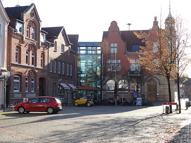
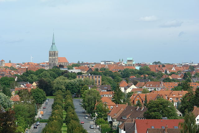
Hamelin
- town in Lower Saxony, Germany
Hiking in Hamelin
Hamelin, located in Lower Saxony, Germany, is best known for the legend of the Pied Piper but also offers a variety of hiking opportunities in and around the region....
- Country:
- Postal Code: 31789; 31787; 31785
- Local Dialing Code: 05158; 05151
- Licence Plate Code: HM
- Coordinates: 52° 6' 11" N, 9° 21' 36" E
- GPS tracks (wikiloc): [Link]
- AboveSeaLevel: 68 м m
- Area: 102.30 sq km
- Population: 56747
- Web site: [Link]

Hessisch Oldendorf
- municipality of Germany
Hiking in Hessisch Oldendorf
Hessisch Oldendorf, located in the district of Hamelin-Pyrmont in Lower Saxony, Germany, is a charming town surrounded by beautiful landscapes that offer a variety of hiking opportunities. The region is characterized by rolling hills, dense forests, and picturesque views of the serpentine river Weser....
- Country:
- Postal Code: 31833; 31840
- Local Dialing Code: 05152
- Licence Plate Code: HM
- Coordinates: 52° 10' 0" N, 9° 15' 0" E
- GPS tracks (wikiloc): [Link]
- AboveSeaLevel: 62 м m
- Area: 120.39 sq km
- Population: 18083
- Web site: [Link]

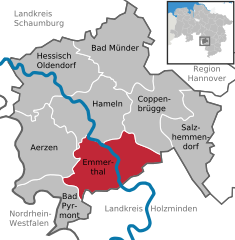
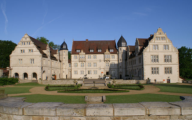
Emmerthal
- municipality of Germany
Hiking in Emmerthal
Emmerthal, located in Lower Saxony, Germany, offers a variety of hiking opportunities that cater to different skill levels and interests. The region is characterized by beautiful landscapes, including forests, rolling hills, and rivers, making it an excellent destination for outdoor enthusiasts....
- Country:
- Postal Code: 31860
- Local Dialing Code: 05151; 05286; 05157; 05155
- Licence Plate Code: HM
- Coordinates: 52° 3' 0" N, 9° 23' 0" E
- GPS tracks (wikiloc): [Link]
- AboveSeaLevel: 69 м m
- Area: 115 sq km
- Population: 9882
- Web site: [Link]

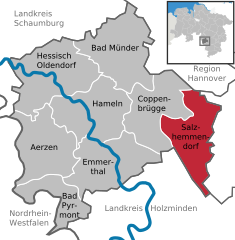
Salzhemmendorf
- municipality in Hameln-Pyrmont district, Lower Saxony, Germany
Hiking in Salzhemmendorf
Salzhemmendorf is a picturesque area in Lower Saxony, Germany, known for its beautiful landscapes, quaint villages, and outdoor activities, making it a great destination for hiking enthusiasts. Here are some highlights and tips for hiking in and around Salzhemmendorf:...
- Country:
- Postal Code: 31020
- Local Dialing Code: 05186; 05153
- Licence Plate Code: HM
- Coordinates: 52° 4' 0" N, 9° 35' 0" E
- GPS tracks (wikiloc): [Link]
- AboveSeaLevel: 130 м m
- Area: 94.39 sq km
- Population: 9217
- Web site: [Link]


Coppenbrügge
- municipality of Germany
Hiking in Coppenbrügge
Coppenbrügge, located in Lower Saxony, Germany, offers a charming backdrop for hiking enthusiasts. The region is characterized by picturesque landscapes, including rolling hills, lush forests, and scenic views. Here are some highlights and tips for hiking in and around Coppenbrügge:...
- Country:
- Postal Code: 31863
- Local Dialing Code: 05159; 05156
- Licence Plate Code: HM
- Coordinates: 52° 7' 14" N, 9° 32' 56" E
- GPS tracks (wikiloc): [Link]
- AboveSeaLevel: 131 м m
- Area: 89.81 sq km
- Population: 6998
- Web site: [Link]

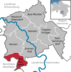
Bad Pyrmont
- town in Lower Saxony, Germany
Hiking in Bad Pyrmont
Bad Pyrmont is a lovely spa town located in the Lower Saxony region of Germany, known for its beautiful landscapes, mineral springs, and a range of outdoor activities including hiking. The area features a variety of trails that cater to different skill levels, making it suitable for both novice and experienced hikers....
- Country:
- Postal Code: 31812
- Local Dialing Code: 05281
- Licence Plate Code: HM
- Coordinates: 51° 59' 12" N, 9° 15' 49" E
- GPS tracks (wikiloc): [Link]
- AboveSeaLevel: 111 м m
- Area: 61.96 sq km
- Population: 19067
- Web site: [Link]
Shares border with regions:

Hanover region
- district in Lower Saxony, Germany
Hiking in Hanover region
The Hanover Region, located in Lower Saxony, Germany, offers a variety of hiking opportunities for both beginners and experienced hikers alike. With its mix of natural landscapes, historical sites, and well-maintained trails, the region is a great destination for outdoor enthusiasts....
- Country:
- Capital: Hanover
- Licence Plate Code: H
- Coordinates: 52° 25' 12" N, 9° 43' 12" E
- GPS tracks (wikiloc): [Link]
- AboveSeaLevel: 55 м m
- Area: 2291 sq km
- Population: 1149594
- Web site: [Link]
Schaumburg
- district in Lower Saxony, Germany
Hiking in Schaumburg
Schaumburg, located in northeastern Illinois, offers some enjoyable options for hiking, despite being a suburban area primarily known for its shopping and amenities. Here are a few notable spots you can explore:...
- Country:
- Licence Plate Code: SHG; RI
- Coordinates: 52° 15' 0" N, 9° 10' 12" E
- GPS tracks (wikiloc): [Link]
- AboveSeaLevel: 84 м m
- Area: 676.00 sq km
- Population: 157616
- Web site: [Link]


Holzminden
- district in Lower Saxony, Germany
Hiking in Holzminden
Holzminden is a picturesque district in Lower Saxony, Germany, characterized by its stunning landscapes, lush forests, and scenic river valleys. It’s an excellent destination for hiking enthusiasts of all levels. Here are some highlights about hiking in Holzminden:...
- Country:
- Licence Plate Code: HOL
- Coordinates: 51° 49' 48" N, 9° 30' 0" E
- GPS tracks (wikiloc): [Link]
- AboveSeaLevel: 177 м m
- Area: 692.00 sq km
- Population: 71510
- Web site: [Link]

Hildesheim
- district in Lower Saxony, Germany
Hiking in Hildesheim
Hildesheim is a beautiful district in Lower Saxony, Germany, known for its rich cultural heritage and scenic landscapes. While it may not be as famous for hiking as some other regions in Germany, there are still several great options for hikers of various skill levels....
- Country:
- Capital: Hildesheim
- Licence Plate Code: HI; ALF
- Coordinates: 52° 4' 48" N, 9° 55' 12" E
- GPS tracks (wikiloc): [Link]
- AboveSeaLevel: 80 м m
- Area: 1206.00 sq km
- Population: 277300
- Web site: [Link]


Lippe
- German district in North Rhine-Westphalia
Hiking in Lippe
Lippe, located in North Rhine-Westphalia, Germany, is known for its picturesque landscapes, historical sites, and diverse hiking opportunities. Here are some key points to consider if you’re planning a hiking trip in the Lippe district:...
- Country:
- Licence Plate Code: LIP
- Coordinates: 52° 0' 0" N, 8° 55' 0" E
- GPS tracks (wikiloc): [Link]
- AboveSeaLevel: 129 м m
- Web site: [Link]