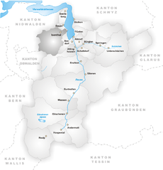
Emmetten (Emmetten)

- municipality in Switzerland
 Hiking in Emmetten
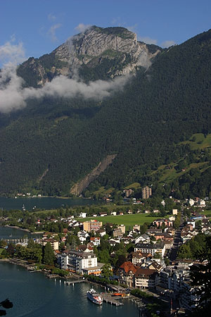
Emmetten is a charming village located in Switzerland, offering stunning views of Lake Lucerne and the surrounding mountains, making it an excellent destination for hiking enthusiasts. Here are some key points to consider when planning a hike in Emmetten:
Scenic Trails
-
Panorama Trail: This trail offers breathtaking views of the surrounding landscapes, including the lake and mountain peaks. It’s well-marked and suitable for hikers of varying skill levels.
-
Emmetten to Niederrickenbach: This hike takes you through beautiful alpine meadows and forests. The path is moderately challenging, with some steep sections, rewarding hikers with gorgeous views of the region.
-
Trek to the Mount Rigi: From Emmetten, it is possible to hike toward Mount Rigi, often referred to as the "Queen of the Mountains." This hike can be extended for more experienced hikers and provides panoramic views.
Accessibility
- Public Transport: Emmetten is accessible via public transport, with connections from larger cities that bring you closer to the trailheads.
- Cable Car: The Emmetten cable car can help you reach higher elevations effortlessly, allowing you to start your hike at a higher point and enjoy the descent or hike to nearby peaks.
Preparation
- Weather Considerations: As with any mountainous region, weather can change rapidly. Always check the forecast and be prepared for varying conditions.
- Gear: Sturdy hiking boots, weather-appropriate clothing, and a good backpack are essential. Consider carrying trekking poles for stability on uneven terrain.
Local Amenities
- Accommodations and Food: Emmetten has several local restaurants and accommodations, allowing you to relax and refuel after a long day of hiking.
Safety Tips
- Always let someone know your hiking plans.
- Carry a map or GPS device as cell service can be spotty in remote areas.
- Be mindful of your fitness level and choose trails that suit your experience.
Exploring the hiking trails in Emmetten can be a rewarding experience, providing an opportunity to immerse yourself in the stunning Swiss landscape. Enjoy your adventure!
- Country:

- Postal Code: 6376
- Local Dialing Code: 041
- Licence Plate Code: NW
- Coordinates: 46° 57' 24" N, 8° 31' 5" E


- GPS tracks (wikiloc): [Link]
- AboveSeaLevel: 774 м m
- Area: 28.63 sq km
- Population: 1401
- Web site: http://www.emmetten.ch
- Wikipedia en: wiki(en)
- Wikipedia: wiki(de)
- Wikidata storage: Wikidata: Q69177
- Wikipedia Commons Category: [Link]
- Freebase ID: [/m/01v25r]
- GeoNames ID: Alt: [7285726]
- VIAF ID: Alt: [243552514]
- OSM relation ID: [1683066]
- archINFORM location ID: [12462]
- HDS ID: [750]
- Swiss municipality code: [1504]
Shares border with regions:


Gersau
- municipality in Switzerland
Hiking in Gersau
Gersau is a picturesque town located on the shores of Lake Lucerne in Switzerland, surrounded by stunning mountains and rich natural landscapes, making it a fantastic destination for hiking enthusiasts. Here are some highlights and tips for hiking in and around Gersau:...
- Country:
- Postal Code: 6442
- Local Dialing Code: 041
- Licence Plate Code: SZ
- Coordinates: 46° 59' 28" N, 8° 31' 29" E
- GPS tracks (wikiloc): [Link]
- AboveSeaLevel: 435 м m
- Area: 23.70 sq km
- Population: 2279
- Web site: [Link]


Seelisberg
- municipality in Switzerland
Hiking in Seelisberg
Seelisberg is a picturesque village located in the Uri region of Switzerland, known for its stunning views of Lake Lucerne and the surrounding mountains. It offers a variety of hiking trails suitable for different skill levels, making it an excellent destination for both novice and experienced hikers....
- Country:
- Postal Code: 6377
- Local Dialing Code: 041
- Licence Plate Code: UR
- Coordinates: 46° 57' 29" N, 8° 34' 21" E
- GPS tracks (wikiloc): [Link]
- AboveSeaLevel: 736 м m
- Area: 13.34 sq km
- Population: 679
- Web site: [Link]

Isenthal
- municipality in Switzerland
Hiking in Isenthal
Isenthal is a beautiful valley located in the heart of Switzerland, specifically in the canton of Uri. It is known for its stunning landscapes, lush meadows, and impressive mountain views, making it a perfect destination for hiking enthusiasts. Here are some key highlights and tips for hiking in Isenthal:...
- Country:
- Postal Code: 6461
- Local Dialing Code: 041
- Licence Plate Code: UR
- Coordinates: 46° 53' 11" N, 8° 31' 28" E
- GPS tracks (wikiloc): [Link]
- AboveSeaLevel: 1404 м m
- Area: 60.99 sq km
- Population: 494
- Web site: [Link]

Ingenbohl
- municipality in Switzerland
Hiking in Ingenbohl
Ingenbohl, located in the canton of Schwyz in Switzerland, is a great place for hiking enthusiasts. Nestled near Lake Lauerz and the surrounding mountains, Ingenbohl offers a mix of flat lakeside trails and more challenging mountainous paths....
- Country:
- Postal Code: 6440
- Local Dialing Code: 041
- Licence Plate Code: SZ
- Coordinates: 47° 0' 14" N, 8° 35' 54" E
- GPS tracks (wikiloc): [Link]
- AboveSeaLevel: 574 м m
- Area: 16.20 sq km
- Population: 8856
- Web site: [Link]


Beckenried
- municipality in Switzerland
Hiking in Beckenried
Beckenried, located in the canton of Nidwalden, Switzerland, is a beautiful destination for hiking enthusiasts. Nestled between Lake Lucerne and the surrounding mountains, it offers a variety of trails with stunning views, diverse landscapes, and the opportunity to explore the natural beauty of the region....
- Country:
- Postal Code: 6375
- Local Dialing Code: 041
- Licence Plate Code: NW
- Coordinates: 46° 57' 59" N, 8° 28' 29" E
- GPS tracks (wikiloc): [Link]
- AboveSeaLevel: 448 м m
- Area: 32.95 sq km
- Population: 3654
- Web site: [Link]