Ennetmoos (Ennetmoos)

- municipality in Switzerland
 Hiking in Ennetmoos
Ennetmoos is a charming village located near Lake Lucerne in Switzerland's scenic region. It is an excellent destination for hiking enthusiasts, offering a variety of trails that cater to different skill levels and preferences. Here are some highlights for hiking in Ennetmoos:
Scenic Trails
-
Panoramaweg: This panoramic trail offers breathtaking views of the surrounding Swiss Alps and Lake Lucerne. The trail is well-marked and suitable for families and casual hikers.
-
Nidwalden Trail: This longer trail takes you through beautiful landscapes, traditional Swiss villages, and offers a glimpse into the local nature and culture.
-
Hiking to Mount Pilatus: While not directly in Ennetmoos, nearby Mount Pilatus is accessible for a more challenging hike. The views from the summit are spectacular, and you can also take a cogwheel train or aerial cableway for part of the journey.
Recommendations
-
Trail Difficulty: There are trails for all levels, from easy lakeside walks to more challenging mountain hikes. Ensure you know your fitness level and choose a suitable trail.
-
Weather Preparedness: Swiss weather can change rapidly. Dress in layers, bring rain gear, and check the local forecast before heading out.
-
Hydration and Snacks: Always carry enough water and snacks, especially on longer hikes, as some trails may not have rest areas.
-
Navigation: Most trails are well-marked, but it's always a good idea to have a physical map or a GPS app on your phone, as coverage may be spotty in remote areas.
Additional Tips
-
Respect Nature: Follow the Leave No Trace principles to keep the trails clean and preserve the natural beauty of Ennetmoos.
-
Start Early: To make the most of your day, start your hikes early in the morning to avoid crowds and enjoy cooler temperatures.
-
Local Guidance: Consider joining a guided hike to learn more about the flora, fauna, and landscape from knowledgeable local guides.
Ennetmoos is a wonderful destination for a hiking getaway, combining natural beauty with Swiss charm. Enjoy your hike!
- Country:

- Postal Code: 6372
- Local Dialing Code: 041
- Licence Plate Code: NW
- Coordinates: 46° 57' 24" N, 8° 20' 14" E


- GPS tracks (wikiloc): [Link]
- AboveSeaLevel: 521 м m
- Area: 14.95 sq km
- Population: 2147
- Web site: http://www.ennetmoos.ch
- Wikipedia en: wiki(en)
- Wikipedia: wiki(de)
- Wikidata storage: Wikidata: Q64599
- Wikipedia Commons Category: [Link]
- Freebase ID: [/m/01v27x]
- GeoNames ID: Alt: [7285735]
- VIAF ID: Alt: [244760494]
- OSM relation ID: [1683069]
- HDS ID: [752]
- Swiss municipality code: [1506]
Shares border with regions:
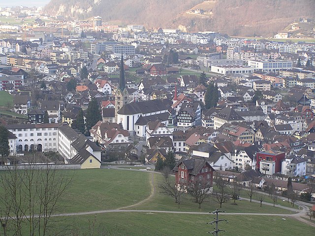

Stans
- municipality in, and capital of, the Swiss canton of Nidwalden
Hiking in Stans
Hiking in Stans, a picturesque town in the Lucerne region of Switzerland, offers a variety of trails that cater to different skill levels and preferences. The stunning backdrop of the Swiss Alps provides a breathtaking experience, making it a popular destination for outdoor enthusiasts. Here are some key points to consider when hiking in Stans:...
- Country:
- Postal Code: 6370
- Local Dialing Code: 041
- Licence Plate Code: NW
- Coordinates: 46° 57' 34" N, 8° 22' 0" E
- GPS tracks (wikiloc): [Link]
- AboveSeaLevel: 452 м m
- Area: 11.08 sq km
- Population: 8411
- Web site: [Link]


Stansstad
- municipality in Switzerland
Hiking in Stansstad
Stansstad, located in the canton of Nidwalden in Switzerland, offers a variety of stunning hiking opportunities. Nestled between Lake Lucerne and the surrounding mountains, it's an ideal destination for both casual walkers and experienced hikers....
- Country:
- Postal Code: 6362
- Local Dialing Code: 041
- Licence Plate Code: NW
- Coordinates: 46° 58' 49" N, 8° 20' 20" E
- GPS tracks (wikiloc): [Link]
- AboveSeaLevel: 436 м m
- Area: 17.11 sq km
- Population: 4494
- Web site: [Link]


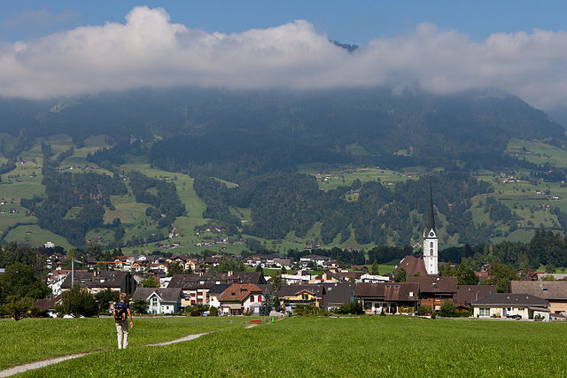
Dallenwil
- municipality in Switzerland
Hiking in Dallenwil
Dallenwil, a charming village located in the canton of Nidwalden, Switzerland, is surrounded by stunning natural landscapes that offer a variety of hiking opportunities. The area is known for its picturesque trails that cater to different skill levels, making it an attractive destination for both beginner and experienced hikers....
- Country:
- Postal Code: 6383
- Local Dialing Code: 041
- Licence Plate Code: NW
- Coordinates: 46° 55' 3" N, 8° 21' 54" E
- GPS tracks (wikiloc): [Link]
- AboveSeaLevel: 1072 м m
- Area: 15.48 sq km
- Population: 1814
- Web site: [Link]

Kerns
- village in the canton of Obwalden, Switzerland
Hiking in Kerns
Kerns is a picturesque area in Utah, known for its stunning landscapes and outdoor recreation opportunities, including hiking. Here are some key points about hiking in Kerns:...
- Country:
- Postal Code: 6064
- Local Dialing Code: 041
- Licence Plate Code: OW
- Coordinates: 46° 50' 23" N, 8° 18' 5" E
- GPS tracks (wikiloc): [Link]
- AboveSeaLevel: 1017 м m
- Area: 92.58 sq km
- Population: 6295
- Web site: [Link]

Alpnach
- municipality in Switzerland
Hiking in Alpnach
Alpnach, located in central Switzerland near Lake Alpnach and the foothills of the Swiss Alps, offers a range of hiking opportunities for outdoor enthusiasts. The area features stunning natural beauty, from lush forests and rolling hills to breathtaking alpine views....
- Country:
- Postal Code: 6055
- Local Dialing Code: 041
- Licence Plate Code: OW
- Coordinates: 46° 57' 0" N, 8° 13' 51" E
- GPS tracks (wikiloc): [Link]
- AboveSeaLevel: 1039 м m
- Area: 56.98 sq km
- Population: 6024
- Web site: [Link]