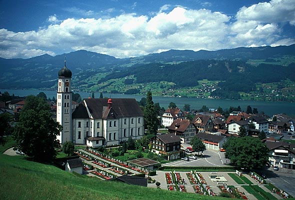
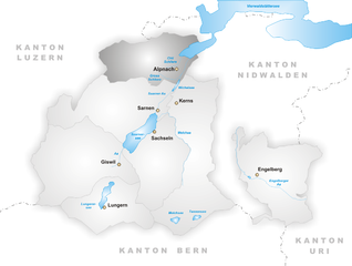
Kerns (Kerns)

- village in the canton of Obwalden, Switzerland
 Hiking in Kerns
Kerns is a picturesque area in Utah, known for its stunning landscapes and outdoor recreation opportunities, including hiking. Here are some key points about hiking in Kerns:
-
Diverse Trails: Kerns offers a variety of hiking trails suitable for different skill levels, from easy walks suitable for families to more challenging hikes for experienced adventurers.
-
Scenic Views: Trails in the area often feature beautiful views of the surrounding mountains, valleys, and, depending on the route, significant landmarks in the Wasatch Range.
-
Wildlife and Ecosystem: Hikers can enjoy the rich biodiversity of the area. Keep an eye out for local wildlife, including deer, birds, and various plant species that are common to the region.
-
Trail Systems: Many trails are part of larger trail systems, which may connect to the Uinta-Wasatch-Cache National Forest, providing extended hiking options and backcountry experiences.
-
Seasonal Considerations: Hiking in Kerns can vary greatly with the seasons. The summer months typically offer the best weather, while winter can bring snow, which may require additional gear like snowshoes or crampons for safety.
-
Safety Tips: Always prepare adequately before heading out—wear suitable hiking boots, bring enough water, snacks, and a map or GPS device. It’s also advisable to let someone know your hiking plans.
-
Local Regulations: Be mindful of local regulations, such as designated trails and area closures, to preserve the natural environment and ensure safety.
For a detailed hike, it's best to research specific trails in Kerns and plan your trip accordingly. If you're looking for recommendations or need assistance with a specific trail, feel free to ask!
- Country:

- Postal Code: 6064
- Local Dialing Code: 041
- Licence Plate Code: OW
- Coordinates: 46° 50' 23" N, 8° 18' 5" E


- GPS tracks (wikiloc): [Link]
- AboveSeaLevel: 1017 м m
- Area: 92.58 sq km
- Population: 6295
- Web site: http://www.kerns.ch
- Wikipedia en: wiki(en)
- Wikipedia: wiki(de)
- Wikidata storage: Wikidata: Q67159
- Wikipedia Commons Category: [Link]
- Freebase ID: [/m/01v1mn]
- GeoNames ID: Alt: [7286187]
- VIAF ID: Alt: [132659574]
- OSM relation ID: [1683086]
- Library of Congress authority ID: Alt: [n90726900]
- MusicBrainz area ID: [95274b92-bec3-4dc1-bfcc-dfdb42e88361]
- HDS ID: [743]
- Swiss municipality code: [1404]
Shares border with regions:


Sarnen
- town in, and capital of, the Swiss canton of Obwalden
Hiking in Sarnen
Sarnen, located in the Canton of Obwalden in Switzerland, is a picturesque destination for hiking enthusiasts. Nestled between beautiful mountains and a tranquil lake, Sarnen offers a variety of hiking trails suitable for different skill levels, making it an ideal spot for both beginners and experienced hikers....
- Country:
- Postal Code: 6060
- Local Dialing Code: 041
- Licence Plate Code: OW
- Coordinates: 46° 53' 49" N, 8° 14' 49" E
- GPS tracks (wikiloc): [Link]
- AboveSeaLevel: 1309 м m
- Area: 70.01 sq km
- Population: 10233
- Web site: [Link]


Lungern
- municipality in Switzerland
Hiking in Lungern
Lungern is a beautiful village situated in the Swiss canton of Obwalden, nestled between the spectacular mountains and alongside the pristine Lungern-Turren Lake. The area offers a variety of hiking opportunities that cater to different skill levels, making it an excellent destination for both casual walkers and seasoned hikers. Here are some highlights of hiking in Lungern:...
- Country:
- Postal Code: 6078
- Local Dialing Code: 041
- Licence Plate Code: OW
- Coordinates: 46° 47' 14" N, 8° 9' 35" E
- GPS tracks (wikiloc): [Link]
- AboveSeaLevel: 716 м m
- Area: 46.47 sq km
- Population: 2122
- Web site: [Link]


Wolfenschiessen
- municipality in Switzerland
Hiking in Wolfenschiessen
Wolfenschiessen is a charming village located in the Nidwalden region of Switzerland, nestled between the well-known mountains of the area. It's an excellent base for hiking enthusiasts due to its stunning natural scenery, well-marked trails, and access to the surrounding alpine landscapes....
- Country:
- Postal Code: 6386
- Local Dialing Code: 041
- Licence Plate Code: NW
- Coordinates: 46° 51' 46" N, 8° 23' 40" E
- GPS tracks (wikiloc): [Link]
- AboveSeaLevel: 1516 м m
- Area: 92.76 sq km
- Population: 2093
- Web site: [Link]


Dallenwil
- municipality in Switzerland
Hiking in Dallenwil
Dallenwil, a charming village located in the canton of Nidwalden, Switzerland, is surrounded by stunning natural landscapes that offer a variety of hiking opportunities. The area is known for its picturesque trails that cater to different skill levels, making it an attractive destination for both beginner and experienced hikers....
- Country:
- Postal Code: 6383
- Local Dialing Code: 041
- Licence Plate Code: NW
- Coordinates: 46° 55' 3" N, 8° 21' 54" E
- GPS tracks (wikiloc): [Link]
- AboveSeaLevel: 1072 м m
- Area: 15.48 sq km
- Population: 1814
- Web site: [Link]


Ennetmoos
- municipality in Switzerland
Hiking in Ennetmoos
Ennetmoos is a charming village located near Lake Lucerne in Switzerland's scenic region. It is an excellent destination for hiking enthusiasts, offering a variety of trails that cater to different skill levels and preferences. Here are some highlights for hiking in Ennetmoos:...
- Country:
- Postal Code: 6372
- Local Dialing Code: 041
- Licence Plate Code: NW
- Coordinates: 46° 57' 24" N, 8° 20' 14" E
- GPS tracks (wikiloc): [Link]
- AboveSeaLevel: 521 м m
- Area: 14.95 sq km
- Population: 2147
- Web site: [Link]

Sachseln
- municipality in Switzerland
Hiking in Sachseln
Sachseln is a beautiful village located in the Obwalden region of Switzerland, near the stunning Lake Sarnen and close to the city of Lucerne. Hiking in and around Sachseln offers a mix of scenic landscapes, cultural experiences, and opportunities for outdoor adventure....
- Country:
- Postal Code: 6072
- Local Dialing Code: 041
- Licence Plate Code: OW
- Coordinates: 46° 52' 4" N, 8° 14' 19" E
- GPS tracks (wikiloc): [Link]
- AboveSeaLevel: 1634 м m
- Area: 53.86 sq km
- Population: 5092
- Web site: [Link]
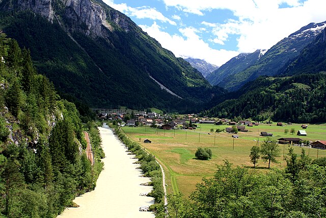

Innertkirchen
- village and municipality in the canton of Bern, Switzerland
Hiking in Innertkirchen
Innertkirchen, located in the Bernese Oberland region of Switzerland, is a fantastic destination for hiking enthusiasts. Nestled between the majestic mountains of the Alps, it offers breathtaking landscapes and a variety of trails suitable for different skill levels. Here’s what you can expect when hiking in and around Innertkirchen:...
- Country:
- Postal Code: 3862
- Local Dialing Code: 033
- Licence Plate Code: BE
- Coordinates: 46° 41' 59" N, 8° 14' 0" E
- GPS tracks (wikiloc): [Link]
- AboveSeaLevel: 625 м m
- Area: 120.0 sq km
- Population: 1076
- Web site: [Link]

Alpnach
- municipality in Switzerland
Hiking in Alpnach
Alpnach, located in central Switzerland near Lake Alpnach and the foothills of the Swiss Alps, offers a range of hiking opportunities for outdoor enthusiasts. The area features stunning natural beauty, from lush forests and rolling hills to breathtaking alpine views....
- Country:
- Postal Code: 6055
- Local Dialing Code: 041
- Licence Plate Code: OW
- Coordinates: 46° 57' 0" N, 8° 13' 51" E
- GPS tracks (wikiloc): [Link]
- AboveSeaLevel: 1039 м m
- Area: 56.98 sq km
- Population: 6024
- Web site: [Link]


Hasliberg
- municipality in the canton of Bern, Switzerland
Hiking in Hasliberg
Hasliberg is a beautiful region located in the Bernese Oberland of Switzerland, famous for its stunning alpine landscapes and extensive network of hiking trails. Here are some key points to consider when hiking in Hasliberg:...
- Country:
- Postal Code: 6085
- Local Dialing Code: 033
- Licence Plate Code: BE
- Coordinates: 46° 44' 47" N, 8° 13' 42" E
- GPS tracks (wikiloc): [Link]
- AboveSeaLevel: 1580 м m
- Area: 41.7 sq km
- Population: 1183
- Web site: [Link]