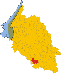
Erbé (Erbé)
- Italian comune
Erbé, a small town in the Province of Verona in Italy, offers a unique landscape for hiking enthusiasts. The area is characterized by its rolling hills, vineyards, and scenic countryside which is typical of the Veneto region.
Here are some key points about hiking in and around Erbé:
-
Routes and Trails: While Erbé itself might not have extensive hiking trails, the nearby Lessinia Regional Park provides various trekking paths that showcase incredible views and diverse flora and fauna. There are trails suitable for all levels ranging from easy walks to more strenuous hikes.
-
Scenic Views: Hiking in the area often rewards trekkers with beautiful panoramas of the surrounding landscape, including vineyards and the distant peaks of the Alps.
-
Cultural Experiences: The trails often intersect with historical sites, quaint villages, and vineyards, allowing hikers to experience the local culture and perhaps enjoy wine tasting or local cuisine at the end of the hike.
-
Best Time to Hike: The best seasons for hiking around Erbé are spring (April to June) and fall (September to October), when the weather is mild and the scenery is particularly beautiful.
-
Things to Prepare: Ensure you have proper hiking gear, including sturdy shoes, weather-appropriate clothing, water, and snacks. Since some areas might not have facilities, it's a good practice to plan your route in advance and inform someone of your trekking plans.
-
Local Hiking Groups: Consider joining local hiking groups or clubs. They often organize guided hikes which can be informative and a great way to meet fellow hiking enthusiasts.
While Erbé itself may not be a major hiking destination, its proximity to more prominent natural parks and scenic routes makes it a lovely spot for a hiking adventure combined with the charm of Italian countryside life. Enjoy your hike!
- Country:

- Postal Code: 37060
- Local Dialing Code: 045
- Licence Plate Code: VR
- Coordinates: 45° 15' 0" N, 10° 58' 0" E


- GPS tracks (wikiloc): [Link]
- AboveSeaLevel: 22 м m
- Area: 16.1 sq km
- Population: 1923
- Web site: http://www.comune.erbe.vr.it/
- Wikipedia en: wiki(en)
- Wikipedia: wiki(it)
- Wikidata storage: Wikidata: Q47868
- Wikipedia Commons Category: [Link]
- Freebase ID: [/m/0gb26p]
- GeoNames ID: Alt: [6538238]
- VIAF ID: Alt: [242730049]
- OSM relation ID: [44471]
- UN/LOCODE: [ITZHY]
- ISTAT ID: 023032
- Italian cadastre code: D419
Shares border with regions:
Castelbelforte
- Italian comune
Castelbelforte is a small town in the Lombardy region of northern Italy, and while it may not be as widely known for hiking as some larger areas, it offers opportunities to explore the natural beauty of the surrounding region. Here are a few points to consider when hiking around Castelbelforte:...
- Country:

- Postal Code: 46032
- Local Dialing Code: 0376
- Licence Plate Code: MN
- Coordinates: 45° 13' 0" N, 10° 53' 0" E


- GPS tracks (wikiloc): [Link]
- AboveSeaLevel: 27 м m
- Area: 22.34 sq km
- Population: 3192
- Web site: [Link]
Trevenzuolo
- Italian comune
Trevenzuolo, a charming municipality located in the province of Verona in Italy, is surrounded by beautiful countryside and offers several opportunities for hiking enthusiasts. While Trevenzuolo itself may not be widely known for extensive hiking trails, its proximity to the Lessini Mountains and the surrounding areas makes it an attractive destination for outdoor activities....
- Country:

- Postal Code: 37060
- Local Dialing Code: 045
- Licence Plate Code: VR
- Coordinates: 45° 16' 0" N, 10° 55' 0" E


- GPS tracks (wikiloc): [Link]
- AboveSeaLevel: 31 м m
- Area: 26.94 sq km
- Population: 2752
- Web site: [Link]
Sorgà
- Italian comune
Sorgà, located in the Veneto region of Italy, is a charming area known more for its agricultural landscape than for extensive hiking trails. However, there are opportunities for pleasant walks and hikes nearby. Here are some insights if you're looking to explore hiking around Sorgà:...
- Country:

- Postal Code: 37060
- Local Dialing Code: 045
- Licence Plate Code: VR
- Coordinates: 45° 13' 0" N, 10° 59' 0" E


- GPS tracks (wikiloc): [Link]
- AboveSeaLevel: 25 м m
- Area: 31.54 sq km
- Population: 3019
- Web site: [Link]


Nogara
- Italian comune
Nogara, located in the province of Verona in Italy, is not widely recognized as a major hiking destination. However, the surrounding regions in the Veneto area and nearby national parks offer some great opportunities for hiking enthusiasts....
- Country:

- Postal Code: 37050; 37054
- Local Dialing Code: 0442
- Licence Plate Code: VR
- Coordinates: 45° 11' 0" N, 11° 4' 0" E


- GPS tracks (wikiloc): [Link]
- AboveSeaLevel: 18 м m
- Area: 38.78 sq km
- Population: 8457
- Web site: [Link]


Isola della Scala
- Italian comune
Isola della Scala, located in the Veneto region of Italy, is primarily known for its agricultural landscape and rice production rather than extensive hiking trails. However, it offers opportunities for leisurely walks and nature exploration in the surrounding areas. Here are some highlights and recommendations for hiking in and around Isola della Scala:...
- Country:

- Postal Code: 37063
- Local Dialing Code: 045
- Licence Plate Code: VR
- Coordinates: 45° 16' 0" N, 11° 8' 0" E


- GPS tracks (wikiloc): [Link]
- AboveSeaLevel: 31 м m
- Area: 69.83 sq km
- Population: 11545
- Web site: [Link]

