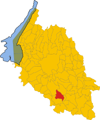
Nogara (Nogara)
- Italian comune
Nogara, located in the province of Verona in Italy, is not widely recognized as a major hiking destination. However, the surrounding regions in the Veneto area and nearby national parks offer some great opportunities for hiking enthusiasts.
-
Nearby Natural Areas: While Nogara itself may not have extensive hiking trails, the nearby Lessinia Regional Park provides beautiful landscapes, mountains, and various trails suited for all hiking levels. It's great for those looking for more challenging hikes with stunning views.
-
Cultural and Historical Explorations: Hiking around Nogara can also include visits to nearby historical landmarks and local culture. You could combine scenic walks with visits to charming towns, vineyards, and traditional farms.
-
Trail Types: When hiking in the area, you may encounter a mix of well-marked trails, unpaved paths, and opportunities for nature observation. Suitable for families and solo hikers alike, trails can range from leisurely walks to more strenuous hikes.
-
Best Time to Hike: The best time for hiking in the Veneto region is typically in the spring (April to June) and fall (September to October) when temperatures are mild, and the scenery is at its best.
-
Preparation: As always, when hiking, ensure you carry plenty of water, wear appropriate footwear, and have maps or a GPS device for navigation, especially in less familiar areas.
If you're keen to hike in the Nogara area, consider exploring the surroundings for the best experience, and always check local resources or connect with local hiking groups for guided options and updated trail conditions!
- Country:

- Postal Code: 37050; 37054
- Local Dialing Code: 0442
- Licence Plate Code: VR
- Coordinates: 45° 11' 0" N, 11° 4' 0" E


- GPS tracks (wikiloc): [Link]
- AboveSeaLevel: 18 м m
- Area: 38.78 sq km
- Population: 8457
- Web site: http://www.comune.nogara.vr.it/
- Wikipedia en: wiki(en)
- Wikipedia: wiki(it)
- Wikidata storage: Wikidata: Q47745
- Wikipedia Commons Category: [Link]
- Freebase ID: [/m/0gb2k1]
- GeoNames ID: Alt: [6540244]
- VIAF ID: Alt: [126665203]
- OSM relation ID: [44373]
- WOEID: [719360]
- UN/LOCODE: [ITNOR]
- ISTAT ID: 023053
- Italian cadastre code: F918
Shares border with regions:
Gazzo Veronese
- Italian comune
Gazzo Veronese, located in the province of Verona in Italy, offers a variety of hiking opportunities for outdoor enthusiasts. This charming area is characterized by its picturesque landscapes, rolling hills, and vineyards, making it a great destination for both leisurely walks and more challenging hikes....
- Country:

- Postal Code: 37060
- Local Dialing Code: 0442
- Licence Plate Code: VR
- Coordinates: 45° 9' 0" N, 11° 5' 0" E


- GPS tracks (wikiloc): [Link]
- AboveSeaLevel: 16 м m
- Area: 56.66 sq km
- Population: 5347
- Web site: [Link]
Sorgà
- Italian comune
Sorgà, located in the Veneto region of Italy, is a charming area known more for its agricultural landscape than for extensive hiking trails. However, there are opportunities for pleasant walks and hikes nearby. Here are some insights if you're looking to explore hiking around Sorgà:...
- Country:

- Postal Code: 37060
- Local Dialing Code: 045
- Licence Plate Code: VR
- Coordinates: 45° 13' 0" N, 10° 59' 0" E


- GPS tracks (wikiloc): [Link]
- AboveSeaLevel: 25 м m
- Area: 31.54 sq km
- Population: 3019
- Web site: [Link]


Salizzole
- Italian comune
Salizzole is a beautiful area located in the Emilia-Romagna region of Italy. It's particularly known for its picturesque landscapes, rolling hills, and charming rural surroundings. While Salizzole itself may not be a major hiking destination, it provides access to nearby natural areas and trails that offer great opportunities for hiking and exploring the Italian countryside....
- Country:

- Postal Code: 37056
- Local Dialing Code: 045
- Licence Plate Code: VR
- Coordinates: 45° 15' 0" N, 11° 5' 0" E


- GPS tracks (wikiloc): [Link]
- AboveSeaLevel: 22 м m
- Area: 30.7 sq km
- Population: 3804
- Web site: [Link]
Erbé
- Italian comune
Erbé, a small town in the Province of Verona in Italy, offers a unique landscape for hiking enthusiasts. The area is characterized by its rolling hills, vineyards, and scenic countryside which is typical of the Veneto region....
- Country:

- Postal Code: 37060
- Local Dialing Code: 045
- Licence Plate Code: VR
- Coordinates: 45° 15' 0" N, 10° 58' 0" E


- GPS tracks (wikiloc): [Link]
- AboveSeaLevel: 22 м m
- Area: 16.1 sq km
- Population: 1923
- Web site: [Link]


Isola della Scala
- Italian comune
Isola della Scala, located in the Veneto region of Italy, is primarily known for its agricultural landscape and rice production rather than extensive hiking trails. However, it offers opportunities for leisurely walks and nature exploration in the surrounding areas. Here are some highlights and recommendations for hiking in and around Isola della Scala:...
- Country:

- Postal Code: 37063
- Local Dialing Code: 045
- Licence Plate Code: VR
- Coordinates: 45° 16' 0" N, 11° 8' 0" E


- GPS tracks (wikiloc): [Link]
- AboveSeaLevel: 31 м m
- Area: 69.83 sq km
- Population: 11545
- Web site: [Link]


Sanguinetto
- Italian comune
Sanguinetto is a small town located in the province of Verona, Italy, and while it may not be widely recognized as a primary hiking destination, it is surrounded by beautiful countryside and scenic landscapes that can offer enjoyable hiking experiences....
- Country:

- Postal Code: 37058
- Local Dialing Code: 0442
- Licence Plate Code: VR
- Coordinates: 45° 10' 59" N, 11° 9' 6" E


- GPS tracks (wikiloc): [Link]
- AboveSeaLevel: 19 м m
- Area: 13.51 sq km
- Population: 4011
- Web site: [Link]

