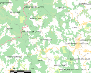
Estivareilles (Estivareilles)
- commune in Loire, France
- Country:

- Postal Code: 42380
- Coordinates: 45° 25' 1" N, 4° 0' 38" E


- GPS tracks (wikiloc): [Link]
- Area: 22.56 sq km
- Population: 694
- Web site: http://www.estivareilles42.fr
- Wikipedia en: wiki(en)
- Wikipedia: wiki(fr)
- Wikidata storage: Wikidata: Q1151544
- Wikipedia Commons Category: [Link]
- Freebase ID: [/m/03qd38b]
- Freebase ID: [/m/03qd38b]
- GeoNames ID: Alt: [6449004]
- GeoNames ID: Alt: [6449004]
- SIREN number: [214200917]
- SIREN number: [214200917]
- BnF ID: [15259660x]
- BnF ID: [15259660x]
- Library of Congress authority ID: Alt: [no2012128927]
- Library of Congress authority ID: Alt: [no2012128927]
- INSEE municipality code: 42091
- INSEE municipality code: 42091
Shares border with regions:


Apinac
- commune in Loire, France
- Country:

- Postal Code: 42550
- Coordinates: 45° 22' 51" N, 3° 59' 46" E


- GPS tracks (wikiloc): [Link]
- Area: 15.35 sq km
- Population: 423
- Web site: [Link]


La Chapelle-en-Lafaye
- commune in Loire, France
- Country:

- Postal Code: 42380
- Coordinates: 45° 27' 46" N, 3° 59' 20" E


- GPS tracks (wikiloc): [Link]
- Area: 8.99 sq km
- Population: 112


Saint-Nizier-de-Fornas
- commune in Loire, France
- Country:

- Postal Code: 42380
- Coordinates: 45° 24' 14" N, 4° 4' 55" E


- GPS tracks (wikiloc): [Link]
- Area: 15.88 sq km
- Population: 669
- Web site: [Link]


Usson-en-Forez
- commune in Loire, France
- Country:

- Postal Code: 42550
- Coordinates: 45° 23' 23" N, 3° 56' 29" E


- GPS tracks (wikiloc): [Link]
- Area: 47.24 sq km
- Population: 1500
- Web site: [Link]


Luriecq
- commune in Loire, France
- Country:

- Postal Code: 42380
- Coordinates: 45° 27' 4" N, 4° 4' 48" E


- GPS tracks (wikiloc): [Link]
- Area: 20.28 sq km
- Population: 1295
- Web site: [Link]


Merle-Leignec
- commune in Loire, France
- Country:

- Postal Code: 42380
- Coordinates: 45° 22' 29" N, 4° 1' 3" E


- GPS tracks (wikiloc): [Link]
- Area: 16.17 sq km
- Population: 319


Marols
- commune in Loire, France
- Country:

- Postal Code: 42560
- Coordinates: 45° 28' 41" N, 4° 2' 42" E


- GPS tracks (wikiloc): [Link]
- Area: 14.94 sq km
- Population: 414


Saillant
- commune in Puy-de-Dôme, France
- Country:

- Postal Code: 63840
- Coordinates: 45° 27' 24" N, 3° 54' 51" E


- GPS tracks (wikiloc): [Link]
- AboveSeaLevel: 940 м m
- Area: 17.42 sq km
- Population: 278


Montarcher
- commune in Loire, France
- Country:

- Postal Code: 42380
- Coordinates: 45° 27' 32" N, 3° 59' 46" E


- GPS tracks (wikiloc): [Link]
- Area: 5.99 sq km
- Population: 66
