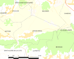
Mottier (Mottier)

- commune in Isère, France
 Hiking in Mottier
Mottier, located in the beautiful area of Isère in the French Alps, offers a variety of hiking opportunities that cater to different skill levels and preferences. The surrounding landscape is characterized by stunning mountain views, diverse flora and fauna, and picturesque trails that are perfect for both day hikes and longer excursions.
Popular Hiking Trails in Mottier
-
Le Circuit des Forges: This moderate trail takes you through lush forests and along historical landmarks from the region’s industrial past. It’s an excellent choice for families.
-
Col de la Croix des Bergers: A more challenging hike that rewards you with breathtaking panoramic views from the summit. This trail is best for experienced hikers looking for a rewarding adventure.
-
La Cascade de Glandieu: A relatively easy hike that leads you to a beautiful waterfall. It’s perfect for a leisurely day out and great for nature photography.
-
Sentier des Fleurs: This trail focuses on botanical diversity, featuring many local flora. It’s a fantastic option for nature lovers and those interested in the local ecosystem.
Tips for Hiking in Mottier
-
Appropriate Gear: Wear sturdy hiking boots and layers of clothing suitable for changes in weather. A good backpack to carry water, snacks, and a first-aid kit is essential.
-
Stay Hydrated: Water sources can be sparse on some trails; always carry enough water for your hike.
-
Trail Maps: While many trails are marked, having a map or GPS can help you stay on track, especially for longer or more remote trails.
-
Respect Nature: Follow Leave No Trace principles. Pack out what you pack in, and be respectful of wildlife and plant life.
-
Check Local Conditions: Weather can change rapidly in the mountains; always check forecasts and trail conditions before heading out.
Mottier is a beautiful destination for hiking, whether you’re there for a short visit or planning a longer stay. Enjoy the trails and the stunning natural beauty of the region!
- Country:

- Postal Code: 38260
- Coordinates: 45° 25' 8" N, 5° 19' 2" E


- GPS tracks (wikiloc): [Link]
- Area: 10.72 sq km
- Population: 690
- Web site: http://www.lemottier.fr
- Wikipedia en: wiki(en)
- Wikipedia: wiki(fr)
- Wikidata storage: Wikidata: Q1068964
- Wikipedia Commons Category: [Link]
- Freebase ID: [/m/03nvkc_]
- GeoNames ID: Alt: [6433260]
- SIREN number: [213802671]
- BnF ID: [15258079f]
- VIAF ID: Alt: [305921010]
- PACTOLS thesaurus ID: [pcrtvl3fxabe6c]
- INSEE municipality code: 38267
Shares border with regions:


Eydoche
- commune in Isère, France
Hiking in Eydoche
It seems like there may be a typographical error in your question, as there is no well-known location called "Eydoche." However, if you meant "Eidoche," "Eidolons," or another similar-sounding name, it's possible it refers to a specific area or national park that's less commonly known....
- Country:
- Postal Code: 38690
- Coordinates: 45° 26' 29" N, 5° 19' 51" E
- GPS tracks (wikiloc): [Link]
- AboveSeaLevel: 629 м m
- Area: 5.58 sq km
- Population: 524
- Web site: [Link]


Nantoin
- commune in Isère, France
Hiking in Nantoin
Nantoin, a beautiful area often associated with the scenic landscapes of the Chartreuse National Park in France, is a fantastic destination for hiking enthusiasts. Here are some key points to consider if you're planning a hike in and around Nantoin:...
- Country:
- Postal Code: 38260
- Coordinates: 45° 26' 8" N, 5° 16' 9" E
- GPS tracks (wikiloc): [Link]
- AboveSeaLevel: 609 м m
- Area: 9.5 sq km
- Population: 464
- Web site: [Link]

Longechenal
- commune in Isère, France
Hiking in Longechenal
Longechenal is a beautiful destination for hiking enthusiasts, located in the picturesque region of Auvergne-Rhône-Alpes in France. Known for its stunning landscapes, diverse terrain, and charming rural atmosphere, this area offers a variety of hiking trails that cater to different levels of experience....
- Country:
- Postal Code: 38690
- Coordinates: 45° 25' 8" N, 5° 20' 52" E
- GPS tracks (wikiloc): [Link]
- Area: 8.12 sq km
- Population: 565


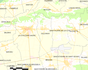
Saint-Hilaire-de-la-Côte
- commune in Isère, France
Hiking in Saint-Hilaire-de-la-Côte
Saint-Hilaire-de-la-Côte is a picturesque mountain village located in the Isère department of the Auvergne-Rhône-Alpes region in southeastern France. It offers a variety of hiking opportunities, attracting both casual walkers and avid trekkers....
- Country:
- Postal Code: 38260
- Coordinates: 45° 23' 26" N, 5° 19' 38" E
- GPS tracks (wikiloc): [Link]
- Area: 13.75 sq km
- Population: 1431
- Web site: [Link]

Gillonnay
- commune in Isère, France
Hiking in Gillonnay
Gillonnay is a charming village located in the Isère department of the Auvergne-Rhône-Alpes region in southeastern France. The area offers a variety of hiking opportunities, ranging from easy walks to more challenging trails, all set against a backdrop of picturesque landscapes and natural beauty....
- Country:
- Postal Code: 38260
- Coordinates: 45° 23' 34" N, 5° 17' 50" E
- GPS tracks (wikiloc): [Link]
- Area: 14.29 sq km
- Population: 1014


Champier
- commune in Isère, France
Hiking in Champier
Champier is a charming village located in the Auvergne-Rhône-Alpes region of France, nestled near the northern edge of the Dauphiné region. While it might not be as famous as some larger locales, it offers a variety of beautiful hiking opportunities through picturesque landscapes that showcase the natural beauty of the area....
- Country:
- Postal Code: 38260
- Coordinates: 45° 27' 12" N, 5° 17' 28" E
- GPS tracks (wikiloc): [Link]
- Area: 14.43 sq km
- Population: 1387
- Web site: [Link]
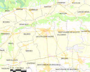
La Côte-Saint-André
- commune in Isère, France
Hiking in La Côte-Saint-André
La Côte-Saint-André is a charming commune located in the Isère department in the Auvergne-Rhône-Alpes region of southeastern France. It offers beautiful landscapes and a variety of hiking opportunities, making it a great destination for outdoor enthusiasts. Here are some highlights about hiking in and around La Côte-Saint-André:...
- Country:
- Postal Code: 38260
- Coordinates: 45° 23' 37" N, 5° 15' 38" E
- GPS tracks (wikiloc): [Link]
- Area: 27.93 sq km
- Population: 4745
- Web site: [Link]