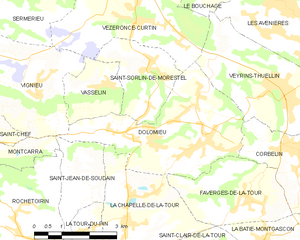
Faverges-de-la-Tour (Faverges-de-la-Tour)

- commune in Isère, France
 Hiking in Faverges-de-la-Tour
Faverges-de-la-Tour, located in the Isère department in the Auvergne-Rhône-Alpes region of France, offers a range of hiking opportunities that showcase the natural beauty of the surrounding area. The region is characterized by its picturesque landscapes, including hills, woodlands, and stunning views of the nearby mountains.
Hiking Trails
-
Local Trails: There are several local paths and trails around Faverges-de-la-Tour that cater to various skill levels, from easy strolls suitable for families to more challenging hikes for experienced adventurers.
-
Mont de la Charme: A popular hiking destination in the area. The hike to the summit provides breathtaking panoramic views of the surrounding countryside and the Taillefer massif.
-
Chemin des Crêtes: This trail is known for its scenic ridges and offers hikers an opportunity to enjoy the diverse flora and fauna of the region.
-
Les Bords du Guiers: A stroll along the Guiers river provides a more leisurely hiking experience with charming riverside views and opportunities for picnicking.
Hiking Tips
- Difficulty Levels: Make sure to assess the difficulty level of the trail you choose and prepare accordingly. Some trails may be rugged or have steep ascents.
- Weather: Check the local weather conditions before heading out, as the weather can change rapidly in mountainous regions.
- Equipment: Bring appropriate hiking gear, including sturdy shoes, water, snacks, and a map or GPS device.
Other Activities
In addition to hiking, Faverges-de-la-Tour's surroundings offer opportunities for cycling, bird watching, and exploring local flora. You can also indulge in the local culture and cuisine after your hike by visiting nearby towns and restaurants.
Overall, Faverges-de-la-Tour is a great destination for hiking enthusiasts looking to enjoy the beauty of the French Alps and the serene environment of the Isère region. Be sure to respect nature and follow local guidelines to ensure a safe and enjoyable experience.
- Country:

- Postal Code: 38110
- Coordinates: 45° 35' 28" N, 5° 31' 25" E


- GPS tracks (wikiloc): [Link]
- Area: 7.67 sq km
- Population: 1330
- Web site: http://www.favergesdelatour.fr
- Wikipedia en: wiki(en)
- Wikipedia: wiki(fr)
- Wikidata storage: Wikidata: Q1069174
- Wikipedia Commons Category: [Link]
- Freebase ID: [/m/03g_6mt]
- GeoNames ID: Alt: [6433198]
- SIREN number: [213801624]
- BnF ID: [152579848]
- VIAF ID: Alt: [238760219]
- INSEE municipality code: 38162
Shares border with regions:


La Chapelle-de-la-Tour
- commune in Isère, France
Hiking in La Chapelle-de-la-Tour
La Chapelle-de-la-Tour is a charming commune located in the Isère department in the Auvergne-Rhône-Alpes region of southeastern France. The area is known for its beautiful landscapes, making it an excellent spot for hiking enthusiasts. Here are some highlights to consider when hiking in and around La Chapelle-de-la-Tour:...
- Country:
- Postal Code: 38110
- Coordinates: 45° 35' 7" N, 5° 27' 47" E
- GPS tracks (wikiloc): [Link]
- Area: 9.04 sq km
- Population: 1757
- Web site: [Link]

Dolomieu
- commune in Isère, France
Hiking in Dolomieu
Hiking in Dolomieu, Isère can be a wonderful experience, offering stunning landscapes and diverse trails. While Dolomieu is a small town, it is surrounded by natural beauty and is close to the Vercors and Chartreuse mountain ranges, which provide a variety of hiking opportunities....
- Country:
- Postal Code: 38110
- Coordinates: 45° 36' 39" N, 5° 29' 57" E
- GPS tracks (wikiloc): [Link]
- Area: 13.32 sq km
- Population: 3079
- Web site: [Link]


Corbelin
- commune in Isère, France
Hiking in Corbelin
Corbelin is a charming village located in the Auvergne-Rhône-Alpes region of France, and it offers a variety of outdoor activities, including hiking. The area is known for its scenic landscapes, wooded hills, and proximity to natural reserves, making it an ideal spot for those who enjoy immersing themselves in nature....
- Country:
- Postal Code: 38630
- Coordinates: 45° 36' 27" N, 5° 32' 41" E
- GPS tracks (wikiloc): [Link]
- Area: 12 sq km
- Population: 2223
- Web site: [Link]


La Bâtie-Montgascon
- commune in Isère, France
Hiking in La Bâtie-Montgascon
La Bâtie-Montgascon is a charming village located in the Auvergne-Rhône-Alpes region of France, near the foothills of the Alps. The area is rich with natural beauty and offers various hiking opportunities for outdoor enthusiasts....
- Country:
- Postal Code: 38110
- Coordinates: 45° 34' 45" N, 5° 31' 41" E
- GPS tracks (wikiloc): [Link]
- Area: 8.43 sq km
- Population: 1890
- Web site: [Link]