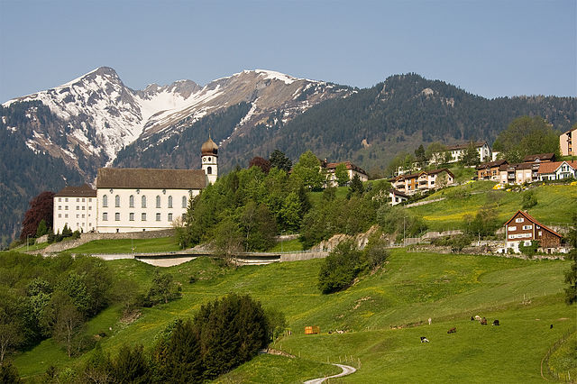
Felsberg (Felsberg)
- municipality in the district of Imboden in the Swiss canton of Graubünden
Felsberg, located in the canton of Graubünden in Switzerland, offers a variety of hiking experiences amidst stunning natural beauty. With its picturesque landscapes, including mountains, valleys, and rivers, Felsberg serves as a great base for both novice and experienced hikers.
Hiking Trails
-
Alpine Trails: Explore the various alpine trails that provide breathtaking views of the surrounding mountains and valleys. The trails vary in difficulty, with some suitable for families and others designed for more advanced hikers.
-
Cultural Routes: Hiking in Felsberg allows you to discover the region’s rich history and culture. Some trails may lead you to historical sites and offer insights into local traditions.
-
Nature Trails: The area is also abundant in flora and fauna. Nature trails are perfect for those interested in wildlife spotting or simply enjoying the serene environment.
-
The Rhine Gorge: Just a short distance from Felsberg, the Rhine Gorge, often referred to as the "Grand Canyon of Switzerland," offers some stunning views and a variety of hiking routes along its rim.
Tips for Hiking in Felsberg
-
Map and Route Planning: Make sure to check local hiking maps and guides. The routes vary in length and elevation gain, so choose one that suits your fitness level.
-
Weather Conditions: The weather in the Swiss Alps can change rapidly. Always check the forecast before heading out and be prepared for varying conditions.
-
Gear Up: Wear appropriate hiking gear, including sturdy shoes, weather-appropriate clothing, and a backpack with essentials such as water, snacks, a first-aid kit, and navigation tools.
-
Respect Nature: Follow local guidelines on preserving the natural environment. Stay on marked trails and avoid disturbing wildlife.
-
Timing: Depending on the season, some trails may be closed due to snow. Summer and early fall are usually the best times for hiking.
Local Amenities
Felsberg has access to local accommodations, restaurants, and shops, where you can enjoy regional cuisine and replenish supplies. Consider staying longer to explore multiple hiking trails and immerse yourself in the local culture.
Conclusion
Hiking in Felsberg, Switzerland, provides a unique combination of breathtaking scenery, cultural insights, and a range of trails for all levels of hikers. Whether you're on a family-friendly stroll or an adventurous trek, the region's beauty and tranquility offer an unforgettable experience.
- Country:

- Postal Code: 7012
- Local Dialing Code: 081
- Licence Plate Code: GR
- Coordinates: 46° 49' 59" N, 9° 27' 59" E


- GPS tracks (wikiloc): [Link]
- AboveSeaLevel: 572 м m
- Area: 13.40 sq km
- Population: 2569
- Web site: http://www.felsberg.ch
- Wikipedia en: wiki(en)
- Wikipedia: wiki(de)
- Wikidata storage: Wikidata: Q64961
- Wikipedia Commons Category: [Link]
- Freebase ID: [/m/0frnst]
- GeoNames ID: Alt: [2660802]
- OSM relation ID: [1684075]
- HDS ID: [1516]
- Facebook Places ID: [109187092441667]
- Swiss municipality code: [3731]
Shares border with regions:


Tamins
- municipality in Switzerland
Tamins, a picturesque village located in the Graubünden region of Switzerland, offers a wonderful setting for hiking enthusiasts. Nestled in the Rhine Valley, surrounded by stunning mountain landscapes, it provides various trails suitable for different skill levels....
- Country:

- Postal Code: 7015
- Local Dialing Code: 081
- Licence Plate Code: GR
- Coordinates: 46° 49' 46" N, 9° 24' 24" E


- GPS tracks (wikiloc): [Link]
- AboveSeaLevel: 1430 м m
- Area: 40.74 sq km
- Population: 1213
- Web site: [Link]


Pfäfers
- municipality in Switzerland
Pfäfers, located in the canton of St. Gallen in Switzerland, is a stunning destination for hiking enthusiasts. The region is renowned for its dramatic landscapes, featuring the picturesque Rhine Gorge, often referred to as the "Grand Canyon of Switzerland." Here are some highlights and tips for hiking in Pfäfers:...
- Country:

- Postal Code: 7312
- Local Dialing Code: 081
- Licence Plate Code: SG
- Coordinates: 46° 58' 59" N, 9° 29' 59" E


- GPS tracks (wikiloc): [Link]
- AboveSeaLevel: 820 м m
- Area: 128.53 sq km
- Population: 1574
- Web site: [Link]


Haldenstein
- municipality in the district of Landquart, Graubünden, Switzerland
Haldenstein, located in the canton of Graubünden in Switzerland, is an excellent destination for hiking enthusiasts. The area is known for its stunning landscapes, picturesque views, and a variety of hiking trails that cater to different skill levels....
- Country:

- Postal Code: 7023
- Local Dialing Code: 081
- Licence Plate Code: GR
- Coordinates: 46° 52' 43" N, 9° 31' 37" E


- GPS tracks (wikiloc): [Link]
- AboveSeaLevel: 1557 м m
- Area: 18.56 sq km
- Population: 1025
- Web site: [Link]


Domat/Ems
- municipality in Switzerland
Domat/Ems is a picturesque village located in the canton of Graubünden, Switzerland. Surrounded by stunning mountain landscapes and lush forests, it offers a variety of hiking opportunities for all levels of experience. Here are some highlights and tips for hiking in and around Domat/Ems:...
- Country:

- Postal Code: 7013
- Local Dialing Code: 081
- Licence Plate Code: GR
- Coordinates: 46° 49' 11" N, 9° 27' 16" E


- GPS tracks (wikiloc): [Link]
- AboveSeaLevel: 991 м m
- Area: 24.22 sq km
- Population: 8070
- Web site: [Link]


Chur
- capital of the Swiss canton of Graubünden and lies in the northern part of the canton
Chur, the capital of the Graubünden canton in Switzerland, offers a fantastic array of hiking opportunities. Nestled in the heart of the Alps, it boasts stunning landscapes that attract both beginner and experienced hikers. Here are some key highlights about hiking in and around Chur:...
- Country:

- Postal Code: 6969
- Local Dialing Code: 081
- Licence Plate Code: GR
- Coordinates: 46° 51' 8" N, 9° 31' 47" E


- GPS tracks (wikiloc): [Link]
- AboveSeaLevel: 593 м m
- Area: 28.09 sq km
- Population: 35038
- Web site: [Link]

