Domat/Ems (Domat/Ems)

- municipality in Switzerland
 Hiking in Domat/Ems
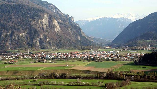
Domat/Ems is a picturesque village located in the canton of Graubünden, Switzerland. Surrounded by stunning mountain landscapes and lush forests, it offers a variety of hiking opportunities for all levels of experience. Here are some highlights and tips for hiking in and around Domat/Ems:
1. :
- Ems River Trail: This trail follows the Ems River and offers beautiful views of the surrounding nature. It's a relatively easy hike, perfect for families and those looking for a leisurely stroll.
- Dummasee Trail: A beautiful hike that takes you to Dummasee, a serene lake surrounded by mountains. The trail features scenic spots ideal for picnicking and photography.
2. :
- You'll find trails suitable for beginners, moderate hikers, and more experienced trekkers. Be sure to check trail markers and signs for difficulty ratings.
3. :
- Gear: Wear sturdy hiking boots and carry a daypack with water, snacks, a map, and a first-aid kit.
- Weather: Check the weather forecast before heading out, as conditions can change rapidly in the mountains.
4. :
- Keep an eye out for local wildlife, including deer, various bird species, and other fauna. Remember to maintain a respectful distance from any animals you encounter.
5. :
- Consider visiting local tourist information centers for detailed maps and advice on the best current trails. Guides are often available who can lead group hikes or provide insights into the area's natural history.
6. :
- Always tell someone your plan, including which trails you intend to hike and your expected return time. Cell service may be limited in certain areas, so it's wise to inform others of your whereabouts.
7. :
- If you have time, explore nearby towns and other hiking areas in Graubünden, which is home to some of Switzerland's most beautiful landscapes, including the famous Engadin valley.
Conclusion:
Hiking in Domat/Ems can be a magical experience, surrounded by the breathtaking scenery of the Swiss Alps. Embrace the tranquility of nature and enjoy the physical activity, and don’t forget to take plenty of photos along the way!
- Country:

- Postal Code: 7013
- Local Dialing Code: 081
- Licence Plate Code: GR
- Coordinates: 46° 49' 11" N, 9° 27' 16" E


- GPS tracks (wikiloc): [Link]
- AboveSeaLevel: 991 м m
- Area: 24.22 sq km
- Population: 8070
- Web site: http://www.domat-ems.ch
- Wikipedia en: wiki(en)
- Wikipedia: wiki(de)
- Wikidata storage: Wikidata: Q68266
- Wikipedia Commons Category: [Link]
Shares border with regions:

Bonaduz
- municipality in Switzerland
Hiking in Bonaduz
Bonaduz, located in the Grisons region of Switzerland, is an excellent destination for hiking enthusiasts. The area is characterized by its stunning natural landscapes, including the surrounding mountains, lush forests, and scenic rivers....
- Country:
- Postal Code: 7402
- Local Dialing Code: 081
- Licence Plate Code: GR
- Coordinates: 46° 48' 19" N, 9° 22' 15" E
- GPS tracks (wikiloc): [Link]
- AboveSeaLevel: 743 м m
- Area: 14.40 sq km
- Population: 3294
- Web site: [Link]


Tamins
- municipality in Switzerland
Hiking in Tamins
Tamins, a picturesque village located in the Graubünden region of Switzerland, offers a wonderful setting for hiking enthusiasts. Nestled in the Rhine Valley, surrounded by stunning mountain landscapes, it provides various trails suitable for different skill levels....
- Country:
- Postal Code: 7015
- Local Dialing Code: 081
- Licence Plate Code: GR
- Coordinates: 46° 49' 46" N, 9° 24' 24" E
- GPS tracks (wikiloc): [Link]
- AboveSeaLevel: 1430 м m
- Area: 40.74 sq km
- Population: 1213
- Web site: [Link]


Felsberg
- municipality in the district of Imboden in the Swiss canton of Graubünden
Hiking in Felsberg
Felsberg, located in the canton of Graubünden in Switzerland, offers a variety of hiking experiences amidst stunning natural beauty. With its picturesque landscapes, including mountains, valleys, and rivers, Felsberg serves as a great base for both novice and experienced hikers....
- Country:
- Postal Code: 7012
- Local Dialing Code: 081
- Licence Plate Code: GR
- Coordinates: 46° 49' 59" N, 9° 27' 59" E
- GPS tracks (wikiloc): [Link]
- AboveSeaLevel: 572 м m
- Area: 13.40 sq km
- Population: 2569
- Web site: [Link]


Rothenbrunnen
- municipality of Switzerland
Hiking in Rothenbrunnen
Rothenbrunnen is a picturesque village situated in the beautiful Surselva region of Switzerland, known for its stunning landscapes, dramatic cliffs, and diverse hiking trails. Here are some highlights and tips for hiking in and around Rothenbrunnen:...
- Country:
- Postal Code: 7405
- Local Dialing Code: 081
- Licence Plate Code: GR
- Coordinates: 46° 46' 40" N, 9° 25' 16" E
- GPS tracks (wikiloc): [Link]
- AboveSeaLevel: 736 м m
- Area: 3.11 sq km
- Population: 311
- Web site: [Link]


Rhäzüns
- municipality in Switzerland
Hiking in Rhäzüns
Rhäzüns is a beautiful municipality located in the Graubünden region of Switzerland, surrounded by stunning landscapes and offering excellent hiking opportunities. The area is characterized by its picturesque mountains, dense forests, and lovely meadows, making it a fantastic destination for outdoor enthusiasts....
- Country:
- Postal Code: 7403
- Local Dialing Code: 081
- Licence Plate Code: GR
- Coordinates: 46° 47' 59" N, 9° 23' 59" E
- GPS tracks (wikiloc): [Link]
- AboveSeaLevel: 657 м m
- Area: 13.37 sq km
- Population: 1494
- Web site: [Link]


Chur
- capital of the Swiss canton of Graubünden and lies in the northern part of the canton
Hiking in Chur
Chur, the capital of the Graubünden canton in Switzerland, offers a fantastic array of hiking opportunities. Nestled in the heart of the Alps, it boasts stunning landscapes that attract both beginner and experienced hikers. Here are some key highlights about hiking in and around Chur:...
- Country:
- Postal Code: 6969
- Local Dialing Code: 081
- Licence Plate Code: GR
- Coordinates: 46° 51' 8" N, 9° 31' 47" E
- GPS tracks (wikiloc): [Link]
- AboveSeaLevel: 593 м m
- Area: 28.09 sq km
- Population: 35038
- Web site: [Link]