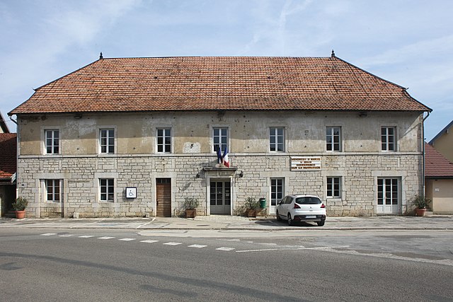
Flagey (Flagey)

- commune in Doubs, France
 Hiking in Flagey
Flagey is a charming village located in the Doubs department in the Bourgogne-Franche-Comté region of eastern France. The area offers picturesque landscapes, rolling hills, and forested trails, making it an excellent spot for hiking enthusiasts.
Hiking Highlights in Flagey:
-
Scenic Trails: The region features a variety of hiking trails suitable for different skill levels, from easy walks to more challenging hikes. The trails often weave through dense forests, past rivers, and offer stunning views of the surrounding countryside.
-
La Vallée de la Loue: Just a short distance from Flagey, the Loue Valley is renowned for its beauty. Hiking along the river allows for serene experiences while exploring the local flora and fauna.
-
Local Flora and Fauna: As you hike, you'll likely encounter diverse plant life, including wildflowers, beech forests, and possibly some wildlife, such as deer and various bird species.
-
Gastronomy: After a day on the trails, you can enjoy local cuisine in nearby restaurants. The Doubs area is known for its dairy products, particularly cheese, and traditional dishes that reflect the local culture.
-
Nearby Attractions: If you have time, consider visiting nearby natural attractions, such as the Doubs River and stunning natural sites like the Cirque de Consolation, which offers breathtaking views and additional hiking opportunities.
Tips for Hiking in Flagey:
- Check the Weather: Be prepared for sudden weather changes, especially if you plan to hike in the autumn or spring.
- Stay Hydrated: Always carry ample water, especially on longer hikes.
- Bring a Map: While many trails are marked, having a physical map or a GPS-enabled device can help ensure you stay on track.
- Respect the Environment: Follow Leave No Trace principles to help preserve the natural beauty of the area.
Whether you’re a seasoned hiker or a beginner, Flagey and its surrounding areas offer a wonderful opportunity to explore nature and enjoy the tranquility of the French countryside.
- Country:

- Postal Code: 25330
- Coordinates: 47° 2' 15" N, 6° 7' 24" E


- GPS tracks (wikiloc): [Link]
- Area: 7.79 sq km
- Population: 153
- Wikipedia en: wiki(en)
- Wikipedia: wiki(fr)
- Wikidata storage: Wikidata: Q908618
- Wikipedia Commons Category: [Link]
- Freebase ID: [/m/03nnjrc]
- Freebase ID: [/m/03nnjrc]
- GeoNames ID: Alt: [6453848]
- GeoNames ID: Alt: [6453848]
- SIREN number: [212502413]
- SIREN number: [212502413]
- BnF ID: [152524673]
- BnF ID: [152524673]
- INSEE municipality code: 25241
- INSEE municipality code: 25241
Shares border with regions:

Amancey
- commune in Doubs, France
Hiking in Amancey
Amancey is a charming commune located in the Doubs department in the Bourgogne-Franche-Comté region of eastern France. Nestled within the beautiful Jura Mountains, it offers a variety of landscapes perfect for hiking enthusiasts. Here are some highlights and tips for hiking in Amancey:...
- Country:
- Postal Code: 25330
- Coordinates: 47° 2' 17" N, 6° 4' 18" E
- GPS tracks (wikiloc): [Link]
- Area: 13.78 sq km
- Population: 670


Ornans
- commune in Doubs, France
Hiking in Ornans
Ornans is a picturesque town located in the Doubs department of eastern France, known for its stunning landscapes, rich culture, and historical significance. Nestled in the Jura Mountains, it offers a variety of hiking opportunities that cater to outdoor enthusiasts of all skill levels....
- Country:
- Postal Code: 25290
- Coordinates: 47° 6' 19" N, 6° 8' 35" E
- GPS tracks (wikiloc): [Link]
- Area: 32.64 sq km
- Population: 4241
- Web site: [Link]

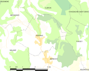
Fertans
- commune in Doubs, France
Hiking in Fertans
Fertans is a small village located in the Jura region of France, known for its beautiful landscapes and nature-friendly environment. Hiking in and around Fertans offers a blend of scenic views, diverse terrains, and the tranquility of the Jura mountains. Here are some details to consider:...
- Country:
- Postal Code: 25330
- Coordinates: 47° 3' 4" N, 6° 3' 48" E
- GPS tracks (wikiloc): [Link]
- Area: 8.19 sq km
- Population: 261


Chassagne-Saint-Denis
- commune in Doubs, France
Hiking in Chassagne-Saint-Denis
Chassagne-Saint-Denis is a charming village in the Burgundy region of France, known for its natural beauty and gentle rolling landscapes. Here are some key points to consider when hiking in and around Chassagne-Saint-Denis:...
- Country:
- Postal Code: 25290
- Coordinates: 47° 5' 0" N, 6° 6' 51" E
- GPS tracks (wikiloc): [Link]
- Area: 9.23 sq km
- Population: 118


Bolandoz
- commune in Doubs, France
Hiking in Bolandoz
Bolandoz is a small commune located in the Bourgogne-Franche-Comté region of France, known for its natural beauty and charming landscapes. While it may not be as widely recognized as other hiking destinations, it offers various opportunities for exploration and enjoying the great outdoors....
- Country:
- Postal Code: 25330
- Coordinates: 47° 1' 7" N, 6° 6' 41" E
- GPS tracks (wikiloc): [Link]
- Area: 12.21 sq km
- Population: 385

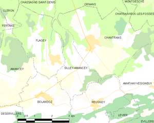
Silley-Amancey
- commune in Doubs, France
Hiking in Silley-Amancey
Silley-Amancey is a charming commune located in the Doubs department of the Bourgogne-Franche-Comté region in eastern France. It offers various hiking opportunities that cater to different skill levels, making it a great spot for outdoor enthusiasts....
- Country:
- Postal Code: 25330
- Coordinates: 47° 1' 55" N, 6° 8' 23" E
- GPS tracks (wikiloc): [Link]
- Area: 5.16 sq km
- Population: 131


Cléron
- commune in Doubs, France
Hiking in Cléron
Cléron is a charming village located in the Doubs department of the Bourgogne-Franche-Comté region in eastern France. It is known for its beautiful landscapes, rich natural environment, and historical significance, making it a great spot for hiking enthusiasts....
- Country:
- Postal Code: 25330
- Coordinates: 47° 5' 14" N, 6° 3' 41" E
- GPS tracks (wikiloc): [Link]
- Area: 14.56 sq km
- Population: 322