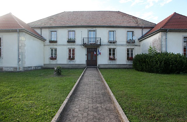
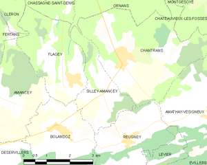
Silley-Amancey (Silley-Amancey)
- commune in Doubs, France
Silley-Amancey is a charming commune located in the Doubs department of the Bourgogne-Franche-Comté region in eastern France. It offers various hiking opportunities that cater to different skill levels, making it a great spot for outdoor enthusiasts.
Trails and Scenery
The area around Silley-Amancey features picturesque landscapes, including rolling hills, forests, and views of the surrounding countryside. A few trails to consider include:
-
Local Nature Trails: There are several marked trails in and around the village that take you through lush forests and open fields, offering opportunities to see local flora and fauna.
-
Monts de la Doubs: This nearby range offers a variety of hiking options with varying difficulty levels, where you can enjoy scenic panoramic views, particularly from elevated points.
-
Lakes and Rivers: Some trails may lead you to nearby rivers and lakes, providing a chance to enjoy peaceful water views and perhaps picnic spots.
Tips for Hiking in Silley-Amancey
- Check Trail Maps: Always carry a detailed map of the area or use a reliable app that can provide you with navigation.
- Weather Preparedness: The weather can change, so dress in layers and be prepared for rain or cooler temperatures, especially in spring and fall.
- Footwear: Wear sturdy hiking boots with good grip, as trails can be uneven and muddy.
- Hydration and Snacks: Bring plenty of water and some energy-boosting snacks, especially for longer hikes.
Accessibility
Many of the hiking trails in Silley-Amancey are accessible, with some being family-friendly. Be sure to assess the difficulty of the trails and choose one that suits your fitness level and experience.
Local Attractions
After your hike, consider exploring the local cultural sites or trying out regional cuisine at nearby restaurants. The hospitality in the region is friendly, and you might have the chance to interact with locals who can share insights about the area.
When planning your hiking trip to Silley-Amancey, always check local resources or visitor centers for the latest information on trail conditions and recommendations. Enjoy your adventure in this beautiful part of France!
- Country:

- Postal Code: 25330
- Coordinates: 47° 1' 55" N, 6° 8' 23" E


- GPS tracks (wikiloc): [Link]
- Area: 5.16 sq km
- Population: 131
- Wikipedia en: wiki(en)
- Wikipedia: wiki(fr)
- Wikidata storage: Wikidata: Q908925
- Wikipedia Commons Category: [Link]
- Freebase ID: [/m/03mhd28]
- GeoNames ID: Alt: [6429995]
- SIREN number: [212505457]
- BnF ID: [152527715]
- INSEE municipality code: 25545
Shares border with regions:


Ornans
- commune in Doubs, France
Ornans is a picturesque town located in the Doubs department of eastern France, known for its stunning landscapes, rich culture, and historical significance. Nestled in the Jura Mountains, it offers a variety of hiking opportunities that cater to outdoor enthusiasts of all skill levels....
- Country:

- Postal Code: 25290
- Coordinates: 47° 6' 19" N, 6° 8' 35" E


- GPS tracks (wikiloc): [Link]
- Area: 32.64 sq km
- Population: 4241
- Web site: [Link]


Chantrans
- commune in Doubs, France
It seems there might be a slight misunderstanding, as "Chantrans" does not appear to be a well-known hiking destination or location as of my last update in October 2023. It could be a misspelling or a less-recognized area. If you meant a specific national park, region, or trail, please clarify the name or provide more context....
- Country:

- Postal Code: 25330
- Coordinates: 47° 2' 36" N, 6° 9' 0" E


- GPS tracks (wikiloc): [Link]
- Area: 14.31 sq km
- Population: 401


Bolandoz
- commune in Doubs, France
Bolandoz is a small commune located in the Bourgogne-Franche-Comté region of France, known for its natural beauty and charming landscapes. While it may not be as widely recognized as other hiking destinations, it offers various opportunities for exploration and enjoying the great outdoors....
- Country:

- Postal Code: 25330
- Coordinates: 47° 1' 7" N, 6° 6' 41" E


- GPS tracks (wikiloc): [Link]
- Area: 12.21 sq km
- Population: 385


Flagey
- commune in Doubs, France
Flagey is a charming village located in the Doubs department in the Bourgogne-Franche-Comté region of eastern France. The area offers picturesque landscapes, rolling hills, and forested trails, making it an excellent spot for hiking enthusiasts....
- Country:

- Postal Code: 25330
- Coordinates: 47° 2' 15" N, 6° 7' 24" E


- GPS tracks (wikiloc): [Link]
- Area: 7.79 sq km
- Population: 153


Reugney
- commune in Doubs, France
Reugney, located in the Vosges department of France, offers a beautiful setting for hiking enthusiasts. The region is characterized by its rolling hills, dense forests, and picturesque landscapes, making it a charming destination for outdoor activities....
- Country:

- Postal Code: 25330
- Coordinates: 47° 0' 45" N, 6° 9' 5" E


- GPS tracks (wikiloc): [Link]
- Area: 8.19 sq km
- Population: 317

