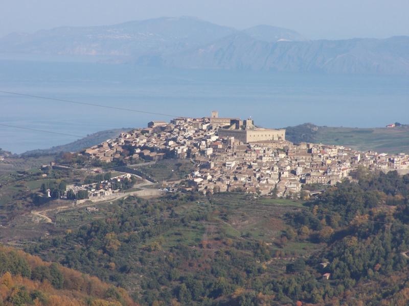
Floresta (Floresta)
.svg)
- Italian comune
 Hiking in Floresta
Floresta, a small town in Sicily, is situated in the Nebrodi Mountains, which offer breathtaking landscapes and rich biodiversity, making it a great destination for hiking enthusiasts. Here are some highlights and tips for hiking in and around Floresta:
Scenic Trails
-
Nebrodi National Park: Floresta is close to this national park, which features numerous trails that cater to all skill levels. You can explore lush forests, stunning lakes, and views of the surrounding mountains.
-
Monte Soro: The highest peak in the Nebrodi range, Monte Soro offers challenging hikes that reward climbers with stunning panoramic views of Sicily and, on clear days, the Aeolian Islands.
-
Lakes and Waterfalls: Look for trails that lead to the beautiful artificial lakes like Lago di Bivio or smaller natural water features. These spots are great for a picnic and resting after a hike.
Flora and Fauna
The Nebrodi Mountains are known for their unique biodiversity. While hiking, you may encounter several endemic plant species and a variety of wildlife, including deer and numerous bird species. Be sure to bring a camera to capture the stunning landscapes and wildlife you might see along the way.
Hiking Tips
- Weather: The weather can vary significantly, so check forecasts before you go. Summer can be hot, while spring and fall offer milder temperatures.
- Gear: Wear sturdy hiking boots and carry plenty of water, snacks, and a basic first aid kit. Also consider bringing trekking poles for stability on uneven terrain.
- Local Guides: Consider hiring a local guide if you’re unfamiliar with the area. They can provide valuable insights and ensure a safer hiking experience.
- Leave No Trace: Ensure you respect the natural environment by following trail etiquette and leaving no trash behind.
Accessibility
Floresta can be reached by car or public transport from larger cities like Catania. Be sure to check the local transport schedules, especially in the off-peak seasons when services may be reduced.
Local Culture
After a day of hiking, take the opportunity to explore Floresta’s charming streets. You can enjoy local cuisine featuring fresh, regional ingredients, or sample some of Sicily’s famous pastries.
Hiking in Floresta can be a rewarding experience, combining the beauty of nature with the charm of Sicilian culture. Enjoy your adventure!
- Country:

- Postal Code: 98030
- Local Dialing Code: 0941
- Licence Plate Code: ME
- Coordinates: 37° 59' 0" N, 14° 55' 0" E


- GPS tracks (wikiloc): [Link]
- AboveSeaLevel: 1275 м m
- Area: 31.33 sq km
- Population: 469
- Web site: http://www.comunefloresta.me.it/
- Wikipedia en: wiki(en)
- Wikipedia: wiki(it)
- Wikidata storage: Wikidata: Q493440
- Wikipedia Commons Category: [Link]
- Freebase ID: [/m/0gqcl6]
- GeoNames ID: Alt: [6537758]
- OSM relation ID: [39449]
- WOEID: [715535]
- ISTAT ID: 083022
- Italian cadastre code: D635
Shares border with regions:

Randazzo
- Italian comune
Hiking in Randazzo
Randazzo is a charming town located in Sicily, Italy, nestled at the foot of Mount Etna. It offers a variety of hiking opportunities that cater to different skill levels, allowing hikers to explore beautiful landscapes, historical sites, and the stunning natural scenery of the region....
- Country:
- Postal Code: 95036
- Local Dialing Code: 095
- Licence Plate Code: CT
- Coordinates: 37° 53' 0" N, 14° 57' 0" E
- GPS tracks (wikiloc): [Link]
- AboveSeaLevel: 765 м m
- Area: 205.62 sq km
- Population: 10763
- Web site: [Link]
Santa Domenica Vittoria
- Italian comune
Hiking in Santa Domenica Vittoria
Santa Domenica Vittoria is a beautiful village located in the Sicilian region of Italy, ideal for hiking enthusiasts who appreciate scenic landscapes, nature, and cultural experiences. Here are some key points to consider when hiking in and around Santa Domenica Vittoria:...
- Country:
- Postal Code: 98030
- Local Dialing Code: 095
- Licence Plate Code: ME
- Coordinates: 37° 55' 0" N, 14° 58' 0" E
- GPS tracks (wikiloc): [Link]
- AboveSeaLevel: 1080 м m
- Area: 20.16 sq km
- Population: 949
- Web site: [Link]


Raccuja
- Italian comune
Hiking in Raccuja
Raccuja, a charming town located in Sicily, Italy, offers access to some stunning hiking opportunities in the surrounding natural landscape. Here are a few highlights and recommendations for hiking in and around Raccuja:...
- Country:
- Postal Code: 98067
- Local Dialing Code: 0941
- Licence Plate Code: ME
- Coordinates: 38° 3' 20" N, 14° 54' 38" E
- GPS tracks (wikiloc): [Link]
- AboveSeaLevel: 640 м m
- Area: 25.2 sq km
- Population: 989
- Web site: [Link]


Ucria
- Italian comune
Hiking in Ucria
Ucria, located in the province of Messina in Sicily, Italy, is an enchanting destination for hiking enthusiasts. The area offers a diverse range of trails that showcase stunning natural landscapes, rich flora, and picturesque views of the Sicilian countryside and mountains....
- Country:
- Postal Code: 98060
- Local Dialing Code: 0941
- Licence Plate Code: ME
- Coordinates: 38° 3' 0" N, 14° 53' 0" E
- GPS tracks (wikiloc): [Link]
- AboveSeaLevel: 710 м m
- Area: 26.26 sq km
- Population: 1014
- Web site: [Link]

Montalbano Elicona
- Italian comune
Hiking in Montalbano Elicona
Montalbano Elicona, a picturesque village located in the province of Messina in Sicily, Italy, is renowned for its stunning landscapes, rich history, and hiking opportunities. Situated at an elevation of around 900 meters, the area offers diverse terrains that appeal to both novice and experienced hikers....
- Country:
- Postal Code: 98065
- Local Dialing Code: 0941
- Licence Plate Code: ME
- Coordinates: 38° 1' 0" N, 15° 1' 0" E
- GPS tracks (wikiloc): [Link]
- AboveSeaLevel: 908 м m
- Area: 67.8 sq km
- Population: 2187
- Web site: [Link]
San Piero Patti
- Italian comune
Hiking in San Piero Patti
San Piero Patti is a charming town located in the province of Messina, Sicily, Italy. Nestled in the hills, it offers a variety of hiking opportunities for outdoor enthusiasts. The region is known for its beautiful landscapes, rich history, and diverse flora and fauna. Here are some things to consider if you're planning to hike in and around San Piero Patti:...
- Country:
- Postal Code: 98068
- Local Dialing Code: 0941
- Licence Plate Code: ME
- Coordinates: 38° 3' 0" N, 14° 58' 0" E
- GPS tracks (wikiloc): [Link]
- AboveSeaLevel: 448 м m
- Area: 41.82 sq km
- Population: 2823
- Web site: [Link]


Tortorici
- Italian comune
Hiking in Tortorici
Tortorici is a charming town located in the Nebrodi Mountains of Sicily, Italy. This area is known for its stunning natural landscapes, rich biodiversity, and various hiking opportunities. Here’s what you need to know about hiking in and around Tortorici:...
- Country:
- Postal Code: 98078
- Local Dialing Code: 0941
- Licence Plate Code: ME
- Coordinates: 38° 1' 51" N, 14° 49' 27" E
- GPS tracks (wikiloc): [Link]
- AboveSeaLevel: 450 м m
- Area: 70.5 sq km
- Population: 6259
- Web site: [Link]