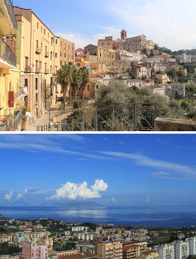
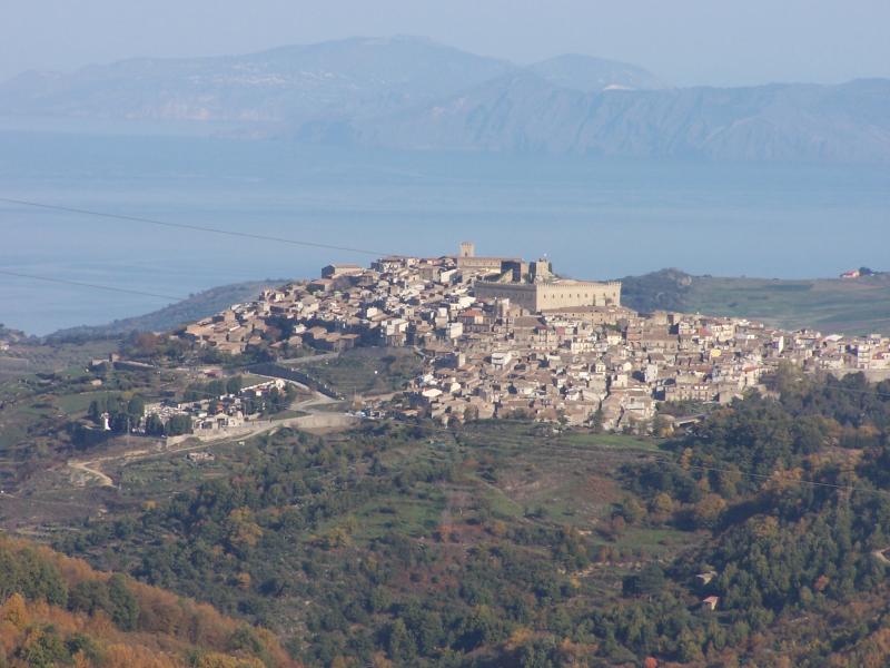
San Piero Patti (San Piero Patti)
.svg)
- Italian comune
 Hiking in San Piero Patti
San Piero Patti is a charming town located in the province of Messina, Sicily, Italy. Nestled in the hills, it offers a variety of hiking opportunities for outdoor enthusiasts. The region is known for its beautiful landscapes, rich history, and diverse flora and fauna. Here are some things to consider if you're planning to hike in and around San Piero Patti:
Hiking Trails
-
Monti Nebrodi Natural Park: Located nearby, this park offers numerous trails that showcase the rugged beauty of the Nebrodi Mountains. You can find trails ranging from easy walks to more challenging hikes, often leading through forests, pastures, and beautiful viewpoints.
-
Local Trails: There are several local trails that wind around the town and its surroundings. These trails often lead to scenic overlooks, small chapels, and historical sites, providing a great way to explore the culture and history of the area.
-
Sicilian Coast: If you venture a bit farther, you can hike along the coastline, enjoying views of the Tyrrhenian Sea. Coastal trails may offer opportunities for swimming and enjoying the beach as well.
Best Time to Hike
- Spring (April to June): This is one of the best times to hike in the region, as the weather is mild and the landscapes are lush and green with wildflowers in bloom.
- Fall (September to November): Another excellent time, with cooler temperatures and fewer crowds. The fall foliage can also provide beautiful scenery.
- Summer (July to August): While hiking is still possible, the heat can be quite intense, so it’s important to start early in the day and stay hydrated.
- Winter (December to February): Some trails may be accessible, but be aware of the potential for rain and colder temperatures.
Tips for Hiking in San Piero Patti
- Gear: Wear sturdy hiking shoes, and bring plenty of water, snacks, a map or GPS device, and sun protection.
- Local Guidance: If you're unfamiliar with the area, consider hiring a local guide or joining a hiking group to ensure you stay on the right trails.
- Wildlife: Keep an eye out for local wildlife, including various bird species and unique plants native to the region.
- Respect Nature: Follow Leave No Trace principles to preserve the natural beauty of the trails.
Cultural Aspects
Hiking around San Piero Patti can also be a cultural experience, as you may encounter old churches, ruins, and local farmhouses along the way. Be sure to take some time to enjoy the local cuisine at nearby restaurants or cafés after your hike.
Whether you're a novice hiker or an experienced adventurer, San Piero Patti offers a picturesque backdrop for outdoor exploration. Enjoy your hiking experience!
- Country:

- Postal Code: 98068
- Local Dialing Code: 0941
- Licence Plate Code: ME
- Coordinates: 38° 3' 0" N, 14° 58' 0" E


- GPS tracks (wikiloc): [Link]
- AboveSeaLevel: 448 м m
- Area: 41.82 sq km
- Population: 2823
- Web site: http://comune.sanpieropatti.me.it/
- Wikipedia en: wiki(en)
- Wikipedia: wiki(it)
- Wikidata storage: Wikidata: Q492980
- Wikipedia Commons Category: [Link]
- Freebase ID: [/m/0gqf23]
- GeoNames ID: Alt: [6539160]
- VIAF ID: Alt: [146615886]
- OSM relation ID: [39512]
- ISTAT ID: 083081
- Italian cadastre code: I086
Shares border with regions:

Patti
- Italian comune
Hiking in Patti
Hiking in Patti, Sicily offers a unique blend of breathtaking coastal views, rich history, and diverse landscapes. Patti is strategically located along the northern coast of Sicily, between the Tyrrhenian Sea and the majestic backdrop of the Nebrodi Mountains. Here are some highlights of hiking in this region:...
- Country:
- Postal Code: 98066
- Local Dialing Code: 0941
- Licence Plate Code: ME
- Coordinates: 38° 8' 0" N, 14° 58' 0" E
- GPS tracks (wikiloc): [Link]
- AboveSeaLevel: 157 м m
- Area: 50.08 sq km
- Population: 13266
- Web site: [Link]


Raccuja
- Italian comune
Hiking in Raccuja
Raccuja, a charming town located in Sicily, Italy, offers access to some stunning hiking opportunities in the surrounding natural landscape. Here are a few highlights and recommendations for hiking in and around Raccuja:...
- Country:
- Postal Code: 98067
- Local Dialing Code: 0941
- Licence Plate Code: ME
- Coordinates: 38° 3' 20" N, 14° 54' 38" E
- GPS tracks (wikiloc): [Link]
- AboveSeaLevel: 640 м m
- Area: 25.2 sq km
- Population: 989
- Web site: [Link]


Sant'Angelo di Brolo
- Italian comune
Hiking in Sant'Angelo di Brolo
Sant'Angelo di Brolo is a picturesque town located in the northeastern part of Sicily, Italy, surrounded by the stunning Madonie and Nebrodi mountain ranges. This region offers a variety of hiking opportunities that cater to different skill levels, from easy walks to more challenging treks....
- Country:
- Postal Code: 98060
- Local Dialing Code: 0941
- Licence Plate Code: ME
- Coordinates: 38° 7' 0" N, 14° 53' 0" E
- GPS tracks (wikiloc): [Link]
- AboveSeaLevel: 314 м m
- Area: 30.39 sq km
- Population: 2983
- Web site: [Link]

Montalbano Elicona
- Italian comune
Hiking in Montalbano Elicona
Montalbano Elicona, a picturesque village located in the province of Messina in Sicily, Italy, is renowned for its stunning landscapes, rich history, and hiking opportunities. Situated at an elevation of around 900 meters, the area offers diverse terrains that appeal to both novice and experienced hikers....
- Country:
- Postal Code: 98065
- Local Dialing Code: 0941
- Licence Plate Code: ME
- Coordinates: 38° 1' 0" N, 15° 1' 0" E
- GPS tracks (wikiloc): [Link]
- AboveSeaLevel: 908 м m
- Area: 67.8 sq km
- Population: 2187
- Web site: [Link]
Floresta
- Italian comune
Hiking in Floresta
Floresta, a small town in Sicily, is situated in the Nebrodi Mountains, which offer breathtaking landscapes and rich biodiversity, making it a great destination for hiking enthusiasts. Here are some highlights and tips for hiking in and around Floresta:...
- Country:
- Postal Code: 98030
- Local Dialing Code: 0941
- Licence Plate Code: ME
- Coordinates: 37° 59' 0" N, 14° 55' 0" E
- GPS tracks (wikiloc): [Link]
- AboveSeaLevel: 1275 м m
- Area: 31.33 sq km
- Population: 469
- Web site: [Link]
Librizzi
- Italian comune
Hiking in Librizzi
Librizzi is a charming village located in the province of Messina, Sicily, Italy. It offers a variety of hiking opportunities that allow you to explore stunning natural landscapes and experience the local culture. Here are some key points about hiking in Librizzi:...
- Country:
- Postal Code: 98064
- Local Dialing Code: 0941
- Licence Plate Code: ME
- Coordinates: 38° 6' 0" N, 14° 57' 0" E
- GPS tracks (wikiloc): [Link]
- AboveSeaLevel: 501 м m
- Area: 23.39 sq km
- Population: 1635
- Web site: [Link]