Fontcouverte-la-Toussuire (Fontcouverte-la-Toussuire)
- commune in Savoie, France
 Hiking in Fontcouverte-la-Toussuire
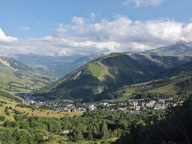
Fontcouverte-la-Toussuire is a picturesque village located in the Savoie region of the French Alps, offering a variety of hiking opportunities for outdoor enthusiasts. Whether you’re a beginner or an advanced hiker, the area provides trails that cater to different skill levels, along with stunning mountain scenery, alpine flora, and the chance to spot local wildlife.
Key Hiking Trails
-
Sentier de la Cascade: This is an easier family-friendly trail that leads to a beautiful waterfall. The path is often well-marked and provides a gentle hike suitable for children and beginners.
-
Mont Charvin Loop: This moderate trail offers breathtaking views of the surrounding mountains. The ascent is challenging but manageable, making it a rewarding experience for those who tackle it. The loop typically takes a few hours and is best suited for intermediate hikers.
-
Col de la Croix de Fer: For those looking for a more difficult hike, this trail leads to higher altitudes and breathtaking panoramic views of the Alps. The rugged terrain requires good physical condition and proper hiking gear.
-
Alpage de la Toussuire: This trail takes you through charming alpine pastures and is a great way to experience the local wildlife and flora. It’s a relatively easy hike that also features spots perfect for a picnic.
Additional Tips
-
Best Time to Hike: The best hiking months in Fontcouverte-la-Toussuire are typically from late spring (May) through early autumn (September). Snow can linger on higher trails into the summer, so it's important to check trail conditions.
-
Stay Hydrated and Prepared: Carry enough water and snacks, wear appropriate footwear, and dress in layers as mountain weather can change quickly.
-
Local Guides: Consider hiring a local guide if you’re unfamiliar with the terrain or if you'd like to learn more about the area’s natural history. They can enhance your hiking experience with insights and ensure your safety.
-
Respect Nature: As with all hiking locations, it's important to follow Leave No Trace principles, respecting wildlife and natural habitats.
Fontcouverte-la-Toussuire provides a fantastic hiking experience framed by the beauty of the French Alps, making it an excellent destination for both novice and experienced hikers alike. Enjoy your hike!
- Country:

- Postal Code: 73300
- Coordinates: 45° 14' 47" N, 6° 18' 9" E


- GPS tracks (wikiloc): [Link]
- Area: 21.52 sq km
- Population: 534
- Web site: http://www.la-toussuire.com
- Wikipedia en: wiki(en)
- Wikipedia: wiki(fr)
- Wikidata storage: Wikidata: Q498217
- Wikipedia Commons Category: [Link]
- Freebase ID: [/m/03npfq4]
- GeoNames ID: Alt: [6617577]
- SIREN number: [217301167]
- BnF ID: [152740505]
- OSM relation ID: [128292]
- INSEE municipality code: 73116
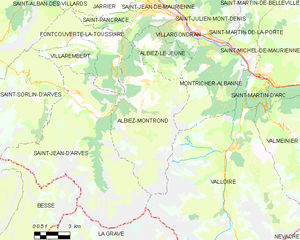
Shares border with regions:


Saint-Alban-des-Villards
- commune in Savoie, France
 Hiking in Saint-Alban-des-Villards
Saint-Alban-des-Villards is a charming village located in the French Alps, specifically in the Savoie department of the Auvergne-Rhône-Alpes region. Hiking in this area offers stunning views, diverse landscapes, and a variety of trails suitable for different skill levels. Here are some highlights and tips for hiking in and around Saint-Alban-des-Villards:...
- Country:

- Postal Code: 73130
- Coordinates: 45° 18' 33" N, 6° 14' 57" E


- GPS tracks (wikiloc): [Link]
- Area: 24.02 sq km
- Population: 103


Saint-Jean-d'Arves
- commune in Savoie, France
Saint-Jean-d'Arves is a picturesque village located in the French Alps, specifically in the Savoie region. This area is renowned for its stunning mountain landscapes, diverse wildlife, and a wide array of hiking opportunities. Here’s what you can expect when hiking in Saint-Jean-d'Arves:...
- Country:

- Postal Code: 73530
- Coordinates: 45° 12' 26" N, 6° 16' 23" E


- GPS tracks (wikiloc): [Link]
- Area: 75.6 sq km
- Population: 265
- Web site: [Link]


Albiez-Montrond
- commune in Savoie, France
Albiez-Montrond is a charming alpine village located in the Savoie region of the French Alps, known for its stunning mountain scenery and outdoor activities, including hiking. Here are some details about hiking in this beautiful area:...
- Country:

- Postal Code: 73300
- Coordinates: 45° 13' 11" N, 6° 20' 27" E


- GPS tracks (wikiloc): [Link]
- Area: 48.58 sq km
- Population: 382
- Web site: [Link]


Saint-Sorlin-d'Arves
- commune in Savoie, France
 Hiking in Saint-Sorlin-d'Arves
Saint-Sorlin-d'Arves is a beautiful alpine village located in the Savoie region of the French Alps. It is particularly known for its stunning landscapes, diverse wildlife, and a range of hiking trails that cater to various skill levels. Here’s a general overview of what you can expect when hiking in the area:...
- Country:

- Postal Code: 73530
- Coordinates: 45° 13' 16" N, 6° 14' 5" E


- GPS tracks (wikiloc): [Link]
- Area: 39 sq km
- Population: 339
- Web site: [Link]


Saint-Jean-de-Maurienne
- commune in Savoie, France
 Hiking in Saint-Jean-de-Maurienne
Saint-Jean-de-Maurienne, located in the Savoie region of the French Alps, is a fantastic destination for hiking enthusiasts, offering a mix of stunning natural landscapes, rich cultural heritage, and a variety of trails suitable for different skill levels....
- Country:

- Postal Code: 73300
- Coordinates: 45° 16' 36" N, 6° 20' 42" E


- GPS tracks (wikiloc): [Link]
- Area: 11.51 sq km
- Population: 7809
- Web site: [Link]
Saint-Pancrace, Savoie
- commune in Savoie, France
 Hiking in Saint-Pancrace, Savoie
Saint-Pancrace, located in the Savoie region of the French Alps, offers a variety of hiking experiences that are suitable for a wide range of skill levels. The breathtaking scenery, characterized by alpine meadows, dense forests, and stunning mountain views, make it an attractive destination for outdoor enthusiasts. Here’s what you need to know about hiking in this area:...
- Country:

- Postal Code: 73300
- Coordinates: 45° 16' 11" N, 6° 19' 32" E


- GPS tracks (wikiloc): [Link]
- Area: 5.59 sq km
- Population: 295


Villarembert
- commune in Savoie, France
Villarembert is a charming village located in the Savoie region of the French Alps, known for its beautiful landscapes and access to numerous hiking trails. It's particularly popular among outdoor enthusiasts due to its proximity to the Maurienne Valley and the Trois Vallées ski area, which transforms into a hiker's paradise in the summer months....
- Country:

- Postal Code: 73300
- Coordinates: 45° 14' 45" N, 6° 16' 46" E


- GPS tracks (wikiloc): [Link]
- Area: 9.58 sq km
- Population: 249
- Web site: [Link]


Saint-Colomban-des-Villards
- commune in Savoie, France
 Hiking in Saint-Colomban-des-Villards
Saint-Colomban-des-Villards is a charming commune in the Savoie region of the French Alps, known for its stunning landscapes and diverse hiking opportunities. The area offers a mix of trails that cater to different skill levels, from leisurely walks to challenging hikes....
- Country:

- Postal Code: 73130
- Coordinates: 45° 17' 39" N, 6° 13' 36" E


- GPS tracks (wikiloc): [Link]
- AboveSeaLevel: 1204 м m
- Area: 81.12 sq km
- Population: 173
