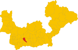
Forcola (Forcola)
- Italian comune
Forcola, located in the beautiful Lombardy region of Italy, is a scenic destination for hiking enthusiasts. Here are some highlights and details about hiking in the Forcola area:
Scenic Trails
- Variety of Routes: The Forcola region offers a mix of hiking trails suitable for all skill levels, from easy walks to more challenging hikes.
- Spectacular Views: Many trails provide stunning views of the surrounding mountains and valleys, especially the Valtellina area and the nearby Alps.
- Natural Beauty: Hikers can experience beautiful forests, meadows, and alpine landscapes, making it a perfect destination for nature lovers.
Accessibility
- Starting Points: Popular starting points for hikes in Forcola include local villages and parking areas where you can access trails easily.
- Signposting: Most trails are well-marked, but it’s always a good idea to carry a map or use a hiking app for navigation.
Best Times to Hike
- Summer: June to September is the best time for hiking in Forcola, as the weather is generally pleasant and all trails are accessible.
- Autumn: October offers beautiful fall colors, although some higher-altitude trails may start to close due to snowfall.
Safety Tips
- Weather Conditions: Always check the weather forecast before heading out, as conditions can change quickly in mountainous areas.
- Gear: Wear appropriate hiking boots and clothing, and bring enough water and snacks.
- Wildlife Awareness: Be mindful of wildlife and respect their habitat. Always keep a safe distance.
Local Culture
- Cultural Experiences: In addition to hiking, the Forcola area can provide opportunities to experience local culture and cuisine, from traditional mountain huts (rifugi) serving hearty meals to small villages with rich histories.
Conclusion
Hiking in Forcola offers an excellent opportunity to enjoy the great outdoors and experience the natural beauty of Northern Italy. Always plan your hikes carefully, and take the time to appreciate the stunning landscapes and landscapes this region has to offer!
- Country:

- Postal Code: 23010
- Local Dialing Code: 0342
- Licence Plate Code: SO
- Coordinates: 46° 9' 0" N, 9° 40' 0" E


- GPS tracks (wikiloc): [Link]
- AboveSeaLevel: 289 м m
- Area: 15.9 sq km
- Population: 796
- Web site: http://www.comune.forcola.so.it
- Wikipedia en: wiki(en)
- Wikipedia: wiki(it)
- Wikidata storage: Wikidata: Q40690
- Wikipedia Commons Category: [Link]
- Freebase ID: [/m/0gj327]
- GeoNames ID: Alt: [6542761]
- OSM relation ID: [46888]
- ISTAT ID: 014029
- Italian cadastre code: D694
Shares border with regions:


Colorina
- Italian comune
It seems there might be a slight typing error in your question regarding "Colorina." If you meant Colorado, there are numerous amazing hiking opportunities in the state. Here are some highlights:...
- Country:

- Postal Code: 23010
- Local Dialing Code: 0342
- Licence Plate Code: SO
- Coordinates: 46° 9' 0" N, 9° 44' 0" E


- GPS tracks (wikiloc): [Link]
- AboveSeaLevel: 385 м m
- Area: 17.84 sq km
- Population: 1423
- Web site: [Link]
Tartano
- Italian comune
Tartano is a mountain area located in the Italian Alps, specifically in the Lombardy region. It offers a range of hiking opportunities for both novice and experienced hikers. The region is known for its breathtaking landscapes, including lush forests, alpine meadows, and stunning panoramic views....
- Country:

- Postal Code: 23010
- Local Dialing Code: 0342
- Licence Plate Code: SO
- Coordinates: 46° 7' 0" N, 9° 41' 0" E


- GPS tracks (wikiloc): [Link]
- AboveSeaLevel: 1210 м m
- Area: 47.27 sq km
- Population: 205
- Web site: [Link]
Buglio in Monte
- Italian comune
Buglio in Monte is a picturesque village located in the Lombardy region of Italy, in the province of Sondrio. The area is known for its stunning natural landscapes, making it an excellent destination for hiking enthusiasts....
- Country:

- Postal Code: 23010
- Local Dialing Code: 0342
- Licence Plate Code: SO
- Coordinates: 46° 11' 0" N, 9° 41' 0" E


- GPS tracks (wikiloc): [Link]
- AboveSeaLevel: 577 м m
- Area: 27.71 sq km
- Population: 2012
- Web site: [Link]
Ardenno
- Italian comune
Ardenno, located in the Valtellina region of northern Italy, offers a beautiful setting for hiking enthusiasts. The area is known for its stunning landscapes, rich flora and fauna, and traditional alpine villages. Here are some key points to consider when hiking in Ardenno:...
- Country:

- Postal Code: 23011
- Local Dialing Code: 0342
- Licence Plate Code: SO
- Coordinates: 46° 10' 0" N, 9° 39' 0" E


- GPS tracks (wikiloc): [Link]
- AboveSeaLevel: 266 м m
- Area: 17.14 sq km
- Population: 3270
- Web site: [Link]
Fusine
- Italian comune
Fusine, located in the Julian Alps of northeastern Italy, is a stunning destination for hiking enthusiasts. The area is known for its picturesque landscapes, crystal-clear alpine lakes, and diverse flora and fauna. Here are some highlights and tips for hiking in Fusine:...
- Country:

- Postal Code: 23010
- Local Dialing Code: 0342
- Licence Plate Code: SO
- Coordinates: 46° 8' 58" N, 9° 44' 59" E


- GPS tracks (wikiloc): [Link]
- AboveSeaLevel: 285 м m
- Area: 37 sq km
- Population: 575
- Web site: [Link]
Talamona
- Italian comune
Talamona, located in the Sondrio province of Lombardy, Italy, is surrounded by stunning landscapes and mountains, making it an excellent destination for hiking enthusiasts....
- Country:

- Postal Code: 23018
- Local Dialing Code: 0342
- Licence Plate Code: SO
- Coordinates: 46° 8' 0" N, 9° 37' 0" E


- GPS tracks (wikiloc): [Link]
- AboveSeaLevel: 285 м m
- Area: 21.05 sq km
- Population: 4671
- Web site: [Link]

