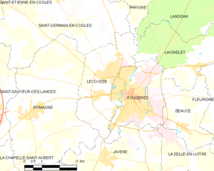
Fougères (Fougères)
- commune in Ille-et-Vilaine, France
- Country:

- Postal Code: 35300
- Coordinates: 48° 21' 6" N, 1° 12' 0" E


- GPS tracks (wikiloc): [Link]
- AboveSeaLevel: 171 м m
- Area: 10.46 sq km
- Population: 20235
- Web site: http://www.fougeres.fr
- Wikipedia en: wiki(en)
- Wikipedia: wiki(fr)
- Wikidata storage: Wikidata: Q4043
- Wikipedia Commons Gallery: [Link]
- Wikipedia Commons Category: [Link]
- Freebase ID: [/m/03m4nn]
- Freebase ID: [/m/03m4nn]
- Freebase ID: [/m/03m4nn]
- GeoNames ID: Alt: [6454042]
- GeoNames ID: Alt: [6454042]
- GeoNames ID: Alt: [6454042]
- SIREN number: [213501158]
- SIREN number: [213501158]
- SIREN number: [213501158]
- BnF ID: [15257059k]
- BnF ID: [15257059k]
- BnF ID: [15257059k]
- VIAF ID: Alt: [167881598]
- VIAF ID: Alt: [167881598]
- VIAF ID: Alt: [167881598]
- OSM relation ID: [163995]
- OSM relation ID: [163995]
- OSM relation ID: [163995]
- GND ID: Alt: [4236852-2]
- GND ID: Alt: [4236852-2]
- GND ID: Alt: [4236852-2]
- archINFORM location ID: [6861]
- archINFORM location ID: [6861]
- archINFORM location ID: [6861]
- Library of Congress authority ID: Alt: [n82088327]
- Library of Congress authority ID: Alt: [n82088327]
- Library of Congress authority ID: Alt: [n82088327]
- PACTOLS thesaurus ID: [pcrth5LIkcpFMN]
- PACTOLS thesaurus ID: [pcrth5LIkcpFMN]
- PACTOLS thesaurus ID: [pcrth5LIkcpFMN]
- MusicBrainz area ID: [37438970-b3ff-499a-bf88-547998767c3f]
- MusicBrainz area ID: [37438970-b3ff-499a-bf88-547998767c3f]
- MusicBrainz area ID: [37438970-b3ff-499a-bf88-547998767c3f]
- Quora topic ID: [Fougères]
- Quora topic ID: [Fougères]
- Quora topic ID: [Fougères]
- Encyclopædia Britannica Online ID: [place/Fougeres]
- Encyclopædia Britannica Online ID: [place/Fougeres]
- Encyclopædia Britannica Online ID: [place/Fougeres]
- National Library of Israel ID: [000993704]
- National Library of Israel ID: [000993704]
- National Library of Israel ID: [000993704]
- YouTube channel ID: [UCI8rHe7QpZJ_BT3On1HTODw]
- YouTube channel ID: [UCI8rHe7QpZJ_BT3On1HTODw]
- YouTube channel ID: [UCI8rHe7QpZJ_BT3On1HTODw]
- INSEE municipality code: 35115
- INSEE municipality code: 35115
- INSEE municipality code: 35115
Shares border with regions:


Beaucé
- commune in Ille-et-Vilaine, France
- Country:

- Postal Code: 35133
- Coordinates: 48° 20' 17" N, 1° 9' 25" E


- GPS tracks (wikiloc): [Link]
- Area: 8.17 sq km
- Population: 1320
- Web site: [Link]


La Selle-en-Luitré
- commune in Ille-et-Vilaine, France
- Country:

- Postal Code: 35133
- Coordinates: 48° 18' 39" N, 1° 7' 38" E


- GPS tracks (wikiloc): [Link]
- Area: 7.32 sq km
- Population: 582
- Web site: [Link]


Laignelet
- commune in Ille-et-Vilaine, France
- Country:

- Postal Code: 35133
- Coordinates: 48° 22' 15" N, 1° 9' 1" E


- GPS tracks (wikiloc): [Link]
- Area: 14.83 sq km
- Population: 1158
- Web site: [Link]


Lécousse
- commune in Ille-et-Vilaine, France
- Country:

- Postal Code: 35133
- Coordinates: 48° 22' 3" N, 1° 13' 4" E


- GPS tracks (wikiloc): [Link]
- Area: 11.07 sq km
- Population: 3178
- Web site: [Link]


Javené
- commune in Ille-et-Vilaine, France
- Country:

- Postal Code: 35133
- Coordinates: 48° 19' 9" N, 1° 12' 57" E


- GPS tracks (wikiloc): [Link]
- Area: 18.45 sq km
- Population: 2055
- Web site: [Link]
