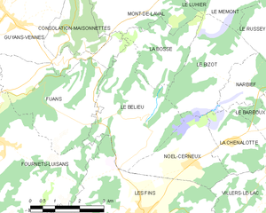
Fournets-Luisans (Fournets-Luisans)

- commune in Doubs, France
 Hiking in Fournets-Luisans
Fournets-Luisans is a picturesque village located in the Doubs department of the Bourgogne-Franche-Comté region in eastern France. The area around Fournets-Luisans offers a variety of hiking opportunities that cater to different skill levels, making it a great destination for outdoor enthusiasts.
Hiking Trails
-
Les Monts de Savoie: The region boasts several trails that wind through the beautiful Jura Mountains, offering stunning views and diverse landscapes. Trails range from easy walks to more challenging hikes.
-
Forest Trails: The surrounding forests are perfect for nature walks, providing shaded paths and a chance to observe local wildlife. Make sure to follow marked trails to preserve the natural habitat.
-
Lake Trails: Nearby lakes, such as the Lac de Saint-Point, can be included in your hiking itinerary. These areas provide a scenic backdrop for leisurely hikes and picnics.
Things to Consider
- Weather Conditions: Always check the weather before heading out, as conditions can change rapidly, especially in mountainous areas.
- Trail Markings: Trails are generally well-marked, but it’s a good idea to bring a map or a GPS device to help navigate.
- Local Regulations: Be aware of specific local regulations regarding wildlife protection and trail use to ensure a responsible hiking experience.
Additional Activities
Aside from hiking, the Fournets-Luisans area offers opportunities for mountain biking, bird watching, and exploring local flora and fauna. The region is also rich in cultural heritage, with opportunities to visit local farms, markets, and historical sites.
Preparation Tips
- Gear: Wear sturdy hiking boots and dress in layers that can be adjusted according to the weather.
- Hydration: Bring plenty of water and snacks to stay energized during your hikes.
- Safety: Hiking with a buddy is always safer. Let someone know your plans for the day.
Whether you are looking for a leisurely walk or a challenging hike, Fournets-Luisans and its surroundings offer something for everyone, all while immersing you in the beautiful French countryside. Enjoy your hikes and stay safe!
- Country:

- Postal Code: 25390
- Coordinates: 47° 6' 42" N, 6° 33' 45" E


- GPS tracks (wikiloc): [Link]
- AboveSeaLevel: 913 м m
- Area: 27.71 sq km
- Population: 668
- Wikipedia en: wiki(en)
- Wikipedia: wiki(fr)
- Wikidata storage: Wikidata: Q838608
- Wikipedia Commons Category: [Link]
- Freebase ID: [/m/03mh8hq]
- Freebase ID: [/m/03mh8hq]
- GeoNames ID: Alt: [6616220]
- GeoNames ID: Alt: [6616220]
- SIREN number: [212502884]
- SIREN number: [212502884]
- BnF ID: [15252514s]
- BnF ID: [15252514s]
- INSEE municipality code: 25288
- INSEE municipality code: 25288
Shares border with regions:


Morteau
- commune in Doubs, France
Hiking in Morteau
Morteau, a charming town located in the Doubs department of France, is surrounded by beautiful landscapes that are perfect for hiking enthusiasts. Nestled near the Jura Mountains and the border with Switzerland, Morteau offers a variety of trails suitable for different skill levels and preferences....
- Country:
- Postal Code: 25500
- Coordinates: 47° 3' 29" N, 6° 36' 22" E
- GPS tracks (wikiloc): [Link]
- Area: 14.11 sq km
- Population: 6849
- Web site: [Link]


Orchamps-Vennes
- commune in Doubs, France
Hiking in Orchamps-Vennes
Orchamps-Vennes is a charming village located in the Doubs department of the Bourgogne-Franche-Comté region in eastern France. This area offers a variety of hiking opportunities that cater to different experience levels, from casual walkers to more experienced hikers....
- Country:
- Postal Code: 25390
- Coordinates: 47° 8' 3" N, 6° 31' 31" E
- GPS tracks (wikiloc): [Link]
- Area: 24.79 sq km
- Population: 2085


Gilley
- commune in Doubs, France
Hiking in Gilley
Gilley is a charming village located in the Doubs department of the Bourgogne-Franche-Comté region in eastern France. It’s a great spot for hiking enthusiasts, offering picturesque landscapes, lush forests, and scenic views of the surrounding Jura mountains....
- Country:
- Postal Code: 25650
- Coordinates: 47° 2' 51" N, 6° 29' 4" E
- GPS tracks (wikiloc): [Link]
- Area: 17.27 sq km
- Population: 1615
- Web site: [Link]


Vennes
- commune in Doubs, France
Hiking in Vennes
Vennes, located in Norway, is known for its stunning natural beauty and diverse hiking opportunities. With breathtaking landscapes, including fjords, mountains, and forests, it offers a variety of trails suitable for all experience levels. Here are some highlights to consider when hiking in Vennes:...
- Country:
- Postal Code: 25390
- Coordinates: 47° 9' 10" N, 6° 32' 50" E
- GPS tracks (wikiloc): [Link]
- AboveSeaLevel: 850 м m
- Area: 7.31 sq km
- Population: 155

Le Bélieu
- commune in Doubs, France
Hiking in Le Bélieu
Le Bélieu is a beautiful region located in the Jura Mountains of Switzerland, known for its stunning landscapes, diverse ecosystems, and excellent hiking opportunities. Here are some highlights and tips for hiking in Le Bélieu:...
- Country:
- Postal Code: 25500
- Coordinates: 47° 7' 9" N, 6° 38' 5" E
- GPS tracks (wikiloc): [Link]
- Area: 10.72 sq km
- Population: 422


Les Combes
- commune in Doubs, France
Hiking in Les Combes
Les Combes is a charming area perfect for hiking, situated in various regions across Europe. If you mean a specific Les Combes, such as the one in the French Alps or another location, please specify. Generally, hiking in Les Combes offers beautiful natural scenery, diverse trails, and varying levels of difficulty suitable for all kinds of hikers....
- Country:
- Postal Code: 25500
- Coordinates: 47° 3' 33" N, 6° 32' 40" E
- GPS tracks (wikiloc): [Link]
- Area: 17.58 sq km
- Population: 726


Fuans
- commune in Doubs, France
Hiking in Fuans
Fuans is a picturesque village located in the Doubs department of France, nestled in the Jura Mountains near the border with Switzerland. It's a great destination for hikers looking for beautiful landscapes, forests, and scenic trails. Here are some highlights and tips for hiking in and around Fuans:...
- Country:
- Postal Code: 25390
- Coordinates: 47° 7' 48" N, 6° 34' 17" E
- GPS tracks (wikiloc): [Link]
- Area: 11.1 sq km
- Population: 486

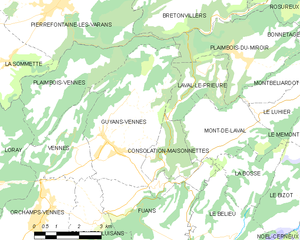
Guyans-Vennes
- commune in Doubs, France
Hiking in Guyans-Vennes
Guyans-Vennes is a quaint municipality located in the Jura region of France, known for its beautiful natural landscapes and opportunities for hiking enthusiasts. Here are some key points to consider when hiking in and around Guyans-Vennes:...
- Country:
- Postal Code: 25390
- Coordinates: 47° 9' 23" N, 6° 34' 15" E
- GPS tracks (wikiloc): [Link]
- Area: 19.67 sq km
- Population: 816


Les Fins
- commune in Doubs, France
Hiking in Les Fins
Les Fins is a charming village located in the Doubs department of the Bourgogne-Franche-Comté region in eastern France, near the Swiss border. The area is known for its beautiful natural landscapes, rolling hills, and rich flora and fauna, making it a great destination for hiking enthusiasts....
- Country:
- Postal Code: 25500
- Coordinates: 47° 4' 51" N, 6° 37' 42" E
- GPS tracks (wikiloc): [Link]
- Area: 25.39 sq km
- Population: 3055