Françay (Françay)

- commune in Loir-et-Cher, France
- Country:

- Postal Code: 41190
- Coordinates: 47° 37' 4" N, 1° 7' 33" E


- GPS tracks (wikiloc): [Link]
- Area: 20.31 sq km
- Population: 281
- Wikipedia en: wiki(en)
- Wikipedia: wiki(fr)
- Wikidata storage: Wikidata: Q1135382
- Wikipedia Commons Category: [Link]
- Freebase ID: [/m/03nw03d]
- GeoNames ID: Alt: [3017384]
- SIREN number: [214100935]
- BnF ID: [152593696]
- INSEE municipality code: 41093
Shares border with regions:
Gombergean
- commune in Loir-et-Cher, France
- Country:
- Postal Code: 41310
- Coordinates: 47° 39' 5" N, 1° 5' 0" E
- GPS tracks (wikiloc): [Link]
- Area: 12.18 sq km
- Population: 196
Herbault
- commune in Loir-et-Cher, France
- Country:
- Postal Code: 41190
- Coordinates: 47° 36' 17" N, 1° 8' 19" E
- GPS tracks (wikiloc): [Link]
- Area: 13.01 sq km
- Population: 1247
Saint-Étienne-des-Guérets
- commune in Loir-et-Cher, France
- Country:
- Postal Code: 41190
- Coordinates: 47° 35' 57" N, 1° 3' 51" E
- GPS tracks (wikiloc): [Link]
- Area: 11.72 sq km
- Population: 95

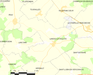
Landes-le-Gaulois
- commune in Loir-et-Cher, France
- Country:
- Postal Code: 41190
- Coordinates: 47° 39' 10" N, 1° 10' 59" E
- GPS tracks (wikiloc): [Link]
- Area: 24.15 sq km
- Population: 739
- Web site: [Link]
Saint-Cyr-du-Gault
- commune in Loir-et-Cher, France
- Country:
- Postal Code: 41190
- Coordinates: 47° 37' 16" N, 1° 1' 48" E
- GPS tracks (wikiloc): [Link]
- Area: 26.06 sq km
- Population: 176
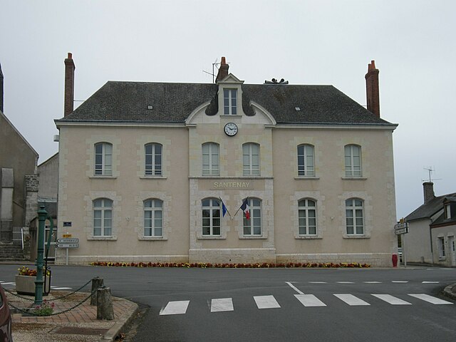

Santenay
- commune in Loir-et-Cher, France
- Country:
- Postal Code: 41190
- Coordinates: 47° 34' 0" N, 1° 6' 59" E
- GPS tracks (wikiloc): [Link]
- Area: 30.28 sq km
- Population: 297


Lancôme
- commune in Loir-et-Cher, France
- Country:
- Postal Code: 41190
- Coordinates: 47° 38' 56" N, 1° 7' 24" E
- GPS tracks (wikiloc): [Link]
- Area: 9.89 sq km
- Population: 124