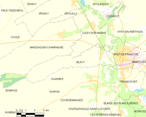
Frignicourt (Frignicourt)

- commune in Marne, France
- Country:

- Postal Code: 51300
- Coordinates: 48° 42' 4" N, 4° 35' 21" E


- GPS tracks (wikiloc): [Link]
- Area: 9.7 sq km
- Population: 1870
- Web site: http://www.frignicourt.fr/
- Wikipedia en: wiki(en)
- Wikipedia: wiki(fr)
- Wikidata storage: Wikidata: Q636618
- Wikipedia Commons Category: [Link]
- Freebase ID: [/m/03qd6wv]
- GeoNames ID: Alt: [6435822]
- SIREN number: [215102435]
- BnF ID: [15262867d]
- INSEE municipality code: 51262
Shares border with regions:


Bignicourt-sur-Marne
- commune in Marne, France
- Country:
- Postal Code: 51300
- Coordinates: 48° 40' 56" N, 4° 36' 32" E
- GPS tracks (wikiloc): [Link]
- Area: 2.83 sq km
- Population: 353

Blacy
- commune in Marne, France
- Country:
- Postal Code: 51300
- Coordinates: 48° 43' 39" N, 4° 33' 12" E
- GPS tracks (wikiloc): [Link]
- Area: 17.26 sq km
- Population: 670

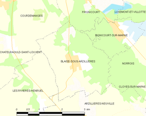
Blaise-sous-Arzillières
- commune in Marne, France
- Country:
- Postal Code: 51300
- Coordinates: 48° 40' 18" N, 4° 35' 1" E
- GPS tracks (wikiloc): [Link]
- Area: 6.89 sq km
- Population: 341
Marolles
- commune in Marne, France
- Country:
- Postal Code: 51300
- Coordinates: 48° 43' 5" N, 4° 37' 31" E
- GPS tracks (wikiloc): [Link]
- Area: 4.38 sq km
- Population: 903
Luxémont-et-Villotte
- commune in Marne, France
- Country:
- Postal Code: 51300
- Coordinates: 48° 41' 45" N, 4° 38' 1" E
- GPS tracks (wikiloc): [Link]
- Area: 9.19 sq km
- Population: 435
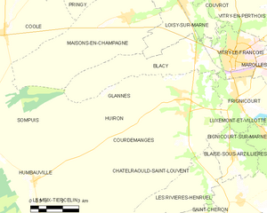
Glannes
- commune in Marne, France
- Country:
- Postal Code: 51300
- Coordinates: 48° 42' 27" N, 4° 32' 25" E
- GPS tracks (wikiloc): [Link]
- AboveSeaLevel: 109 м m
- Area: 13.1 sq km
- Population: 192

Vitry-le-François
- commune in Marne, France
- Country:
- Postal Code: 51300
- Coordinates: 48° 43' 29" N, 4° 35' 4" E
- GPS tracks (wikiloc): [Link]
- AboveSeaLevel: 105 м m
- Area: 6.45 sq km
- Population: 12805
- Web site: [Link]


Courdemanges
- commune in Marne, France
- Country:
- Postal Code: 51300
- Coordinates: 48° 41' 43" N, 4° 32' 30" E
- GPS tracks (wikiloc): [Link]
- Area: 19.16 sq km
- Population: 391


Huiron
- commune in Marne, France
- Country:
- Postal Code: 51300
- Coordinates: 48° 42' 8" N, 4° 32' 28" E
- GPS tracks (wikiloc): [Link]
- Area: 13.28 sq km
- Population: 302