
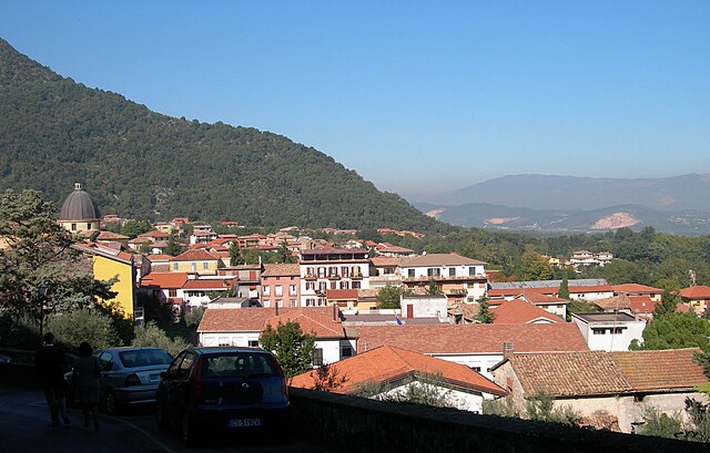
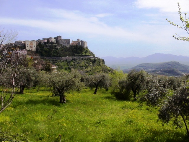
Frosinone (Frosinone)
.svg)
- Italian comune
 Hiking in Frosinone
Frosinone, located in the Lazio region of Italy, offers a variety of hiking opportunities that cater to different skill levels and interests. The region is known for its beautiful landscapes, historical sites, and natural parks. Here are some highlights and tips for hiking in Frosinone:
Notable Hiking Areas
-
Parco Nazionale d'Abruzzo, Lazio e Molise:
- Although primarily located in Abruzzo, this national park extends into the Frosinone province and offers stunning trails. You can explore lush forests, rivers, and diverse wildlife.
-
Monti Ernici:
- This mountain range offers numerous trails that range from easy to challenging. Hikes here provide breathtaking views of both the Lazio and Abruzzo regions. The area is also rich in flora and fauna.
-
Cascate di Monte Gelato:
- A more family-friendly hiking option, this area features scenic waterfalls and beautiful landscapes. The trails are relatively easy and perfect for a leisurely day outdoors.
-
Parco Regionale dei Monti Ausoni e Lake di Fondi:
- The Ausoni Mountains offer a variety of hiking paths with varying difficulty levels. The park is noted for its beautiful scenery, historical sites, and opportunities for wildlife observation.
Tips for Hiking in Frosinone
-
Check Trail Conditions: Before heading out, check local resources for trail conditions and potential closures. Weather can impact the accessibility of certain paths.
-
Water and Snacks: Carry enough water and snacks, as some trails may be remote and lacking in facilities.
-
Dress Appropriately: Wear suitable hiking shoes and dress in layers. Weather can change quickly, especially in higher altitudes.
-
Leave No Trace: Follow the Leave No Trace principles to preserve the natural beauty and environment of the area.
-
Safety: Always inform someone about your plans, especially if you're hiking in more remote areas. Consider bringing a map or a GPS device, as cell service may be spotty.
Conclusion
Hiking in Frosinone is a wonderful way to experience the natural beauty and cultural heritage of the region. With its diverse landscapes and rich ecosystems, it’s an excellent destination for both novice and experienced hikers alike. Make sure to respect the environment and enjoy your outdoor adventures!
- Country:

- Postal Code: 03100
- Local Dialing Code: 0775
- Licence Plate Code: FR
- Coordinates: 41° 38' 0" N, 13° 21' 0" E


- GPS tracks (wikiloc): [Link]
- AboveSeaLevel: 291 м m
- Area: 46.85 sq km
- Population: 46063
- Web site: http://www.comune.frosinone.it
- Wikipedia en: wiki(en)
- Wikipedia: wiki(it)
- Wikidata storage: Wikidata: Q13413
- Wikipedia Commons Gallery: [Link]
- Wikipedia Commons Category: [Link]
- Freebase ID: [/m/03wj5j]
- GeoNames ID: Alt: [6541853]
- VIAF ID: Alt: [145852474]
- OSM relation ID: [41419]
- GND ID: Alt: [4362865-5]
- archINFORM location ID: [7149]
- Library of Congress authority ID: Alt: [nr92015720]
- MusicBrainz area ID: [21eb4d69-9a18-4e8a-a22d-c22e52e2494b]
- UN/LOCODE: [ITFRO]
- Encyclopædia Britannica Online ID: [place/Frosinone-Italy]
- Digital Atlas of the Roman Empire ID: [22660]
- DMOZ ID: Alt: [Regional/Europe/Italy/Lazio/Localities/Frosinone/]
- Pleiades ID: [432852]
- ISTAT ID: 060038
- Italian cadastre code: D810
Shares border with regions:
Arnara
- Italian comune
Hiking in Arnara
Arnara, a village located in the province of Frosinone in Italy, offers a unique hiking experience characterized by beautiful landscapes, rich history, and a variety of trails that cater to different skill levels....
- Country:
- Postal Code: 03020
- Local Dialing Code: 0775
- Licence Plate Code: FR
- Coordinates: 41° 35' 0" N, 13° 23' 0" E
- GPS tracks (wikiloc): [Link]
- AboveSeaLevel: 250 м m
- Area: 12.29 sq km
- Population: 2292
- Web site: [Link]


Ceccano
- Italian comune
Hiking in Ceccano
Ceccano is a charming town in the province of Frosinone, Italy, nestled in the picturesque landscape of the Apennine Mountains. It offers several hiking opportunities that allow visitors to explore its natural beauty and rich history. Here are some key points about hiking in and around Ceccano:...
- Country:
- Postal Code: 03023
- Local Dialing Code: 0775
- Licence Plate Code: FR
- Coordinates: 41° 34' 0" N, 13° 20' 0" E
- GPS tracks (wikiloc): [Link]
- AboveSeaLevel: 200 м m
- Area: 61.06 sq km
- Population: 23380
- Web site: [Link]


Patrica
- Italian comune
Hiking in Patrica
Patrica, located in Italy, is known for its picturesque landscapes and hiking opportunities. Nestled within the beautiful region of Lazio, Patrica offers a mix of natural beauty, historical sites, and charming villages, making it a great spot for outdoor enthusiasts....
- Country:
- Postal Code: 03010
- Local Dialing Code: 0775
- Licence Plate Code: FR
- Coordinates: 41° 35' 0" N, 13° 15' 0" E
- GPS tracks (wikiloc): [Link]
- AboveSeaLevel: 450 м m
- Area: 27.31 sq km
- Population: 3161
- Web site: [Link]

Supino
- Italian comune
Hiking in Supino
Supino is a charming town in the province of Frosinone, Italy, located near the Amaseno valley. The surrounding region offers beautiful landscapes that are great for hiking enthusiasts. Here are some highlights and tips for hiking in and around Supino:...
- Country:
- Postal Code: 03019
- Local Dialing Code: 0775
- Licence Plate Code: FR
- Coordinates: 41° 37' 0" N, 13° 14' 0" E
- GPS tracks (wikiloc): [Link]
- AboveSeaLevel: 321 м m
- Area: 35.59 sq km
- Population: 4825
- Web site: [Link]
Torrice
- Italian comune
Hiking in Torrice
Torrice, a charming town in Italy, may not be widely known for hiking compared to more prominent regions, but it is nestled in the beautiful province of Frosinone in Lazio, making it a great starting point for exploring the surrounding natural landscapes....
- Country:
- Postal Code: 03020
- Local Dialing Code: 0775
- Licence Plate Code: FR
- Coordinates: 41° 38' 0" N, 13° 24' 0" E
- GPS tracks (wikiloc): [Link]
- AboveSeaLevel: 321 м m
- Area: 18.06 sq km
- Population: 4843
- Web site: [Link]


Alatri
- Italian comune
Hiking in Alatri
Alatri, located in the province of Frosinone in Italy, is a charming town known for its rich history and stunning landscapes, making it a great destination for hikers. The surrounding countryside offers numerous trails that cater to various skill levels, whether you’re a beginner or an experienced hiker....
- Country:
- Postal Code: 03011
- Local Dialing Code: 0775
- Licence Plate Code: FR
- Coordinates: 41° 43' 35" N, 13° 20' 32" E
- GPS tracks (wikiloc): [Link]
- AboveSeaLevel: 502 м m
- Area: 96.96 sq km
- Population: 28763
- Web site: [Link]

Veroli
- Italian comune
Hiking in Veroli
Veroli, a charming town situated in the province of Frosinone in the Lazio region of Italy, offers excellent opportunities for hiking enthusiasts. Nestled in the beautiful hills of the Ciociaria area, Veroli boasts stunning landscapes, rich history, and a variety of trails suitable for different experience levels....
- Country:
- Postal Code: 03029
- Local Dialing Code: 0775
- Licence Plate Code: FR
- Coordinates: 41° 41' 0" N, 13° 25' 0" E
- GPS tracks (wikiloc): [Link]
- AboveSeaLevel: 594 м m
- Area: 119.65 sq km
- Population: 20414
- Web site: [Link]


Ferentino
- town and comune in Italy
Hiking in Ferentino
Ferentino, located in the province of Frosinone in Italy, offers a wonderful setting for hiking enthusiasts. Surrounded by the beautiful landscape of the Lepini Mountains and close to the Amaseno Valley, Ferentino features a variety of trails that cater to different skill levels. Here are some highlights of hiking in this area:...
- Country:
- Postal Code: 03013
- Local Dialing Code: 0775
- Licence Plate Code: FR
- Coordinates: 41° 41' 0" N, 13° 15' 0" E
- GPS tracks (wikiloc): [Link]
- AboveSeaLevel: 393 м m
- Area: 81 sq km
- Population: 20992
- Web site: [Link]