Gabre (Gabre)
- commune in Ariège, France
- Country:

- Postal Code: 09290
- Coordinates: 43° 4' 30" N, 1° 25' 3" E


- GPS tracks (wikiloc): [Link]
- Area: 13.36 sq km
- Population: 112
- Wikipedia en: wiki(en)
- Wikipedia: wiki(fr)
- Wikidata storage: Wikidata: Q1086972
- Wikipedia Commons Category: [Link]
- Freebase ID: [/m/03m8mgs]
- GeoNames ID: Alt: [6426201]
- SIREN number: [210901278]
- VIAF ID: Alt: [238135057]
- INSEE municipality code: 09127
Shares border with regions:

Le Mas-d'Azil
- commune in Ariège, France
- Country:
- Postal Code: 09290
- Coordinates: 43° 4' 50" N, 1° 21' 38" E
- GPS tracks (wikiloc): [Link]
- Area: 39.36 sq km
- Population: 1187

Pailhès
- commune in Ariège, France
- Country:
- Postal Code: 09130
- Coordinates: 43° 6' 8" N, 1° 26' 33" E
- GPS tracks (wikiloc): [Link]
- Area: 21.52 sq km
- Population: 458

Montégut-Plantaurel
- commune in Ariège, France
- Country:
- Postal Code: 09120
- Coordinates: 43° 4' 9" N, 1° 29' 8" E
- GPS tracks (wikiloc): [Link]
- Area: 18.95 sq km
- Population: 342

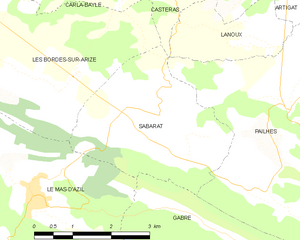
Sabarat
- commune in Ariège, France
- Country:
- Postal Code: 09350
- Coordinates: 43° 5' 59" N, 1° 23' 20" E
- GPS tracks (wikiloc): [Link]
- Area: 9.5 sq km
- Population: 327

Aigues-Juntes
- commune in Ariège, France
- Country:
- Postal Code: 09240
- Coordinates: 43° 3' 20" N, 1° 28' 15" E
- GPS tracks (wikiloc): [Link]
- Area: 7.77 sq km
- Population: 64

La Bastide-de-Sérou
- commune in Ariège, France
- Country:
- Postal Code: 09240
- Coordinates: 43° 0' 43" N, 1° 25' 40" E
- GPS tracks (wikiloc): [Link]
- Area: 43.62 sq km
- Population: 961
- Web site: [Link]