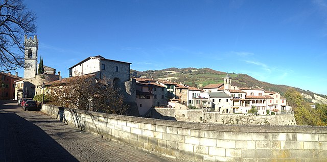
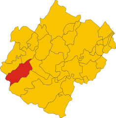
Galeata (Galeata)
.svg)
- Italian comune
 Hiking in Galeata
Galeata is a charming rural area located in the Emilia-Romagna region of Italy, known for its picturesque landscapes and rich natural heritage. Here are some insights into hiking in and around Galeata:
Trail Options
-
Sentiero degli Alpini: This trail offers stunning views and leads through beautiful forests and alpine meadows. It is well-marked and suitable for various skill levels.
-
Monte Fumaiolo: A bit of a drive from Galeata, this mountain features several trails that offer panoramic views of the surrounding landscape, including the famous source of the Tiber River.
-
Foresta di Certomondo: This forested area offers peaceful trails and opportunities for birdwatching and enjoying the local flora.
Tips for Hiking in Galeata
- Check Trail Conditions: Before setting out, check the trail conditions and weather forecasts as they can change quickly in mountainous areas.
- Dress Appropriately: Wear layered clothing, sturdy hiking boots, and don’t forget a hat and sunscreen.
- Bring Essentials: Water, snacks, a first aid kit, and a map or GPS device are key for a safe hiking experience.
- Respect Nature: Stay on marked trails, carry out what you bring in, and adhere to local guidelines to preserve the natural beauty.
Best Time to Hike
The best seasons for hiking in Galeata are spring and early autumn when the weather is more favorable, and the scenery is particularly beautiful with blooming wildflowers and vibrant fall colors.
Local Culture and Attractions
After a day of hiking, explore the local culture, including traditional cuisine at nearby trattorias, and consider visiting historical sites in Galeata, such as the medieval churches and charming old town.
Conclusion
Galeata offers a peaceful hiking experience in a lush, natural setting, making it a wonderful destination for both beginners and seasoned hikers. Enjoy your adventure!
- Country:

- Postal Code: 47010
- Local Dialing Code: 0543
- Licence Plate Code: FC
- Coordinates: 44° 0' 0" N, 11° 55' 0" E


- GPS tracks (wikiloc): [Link]
- AboveSeaLevel: 237 м m
- Area: 63.13 sq km
- Population: 2511
- Web site: http://www.comune.galeata.fo.it/
- Wikipedia en: wiki(en)
- Wikipedia: wiki(it)
- Wikidata storage: Wikidata: Q99941
- Wikipedia Commons Gallery: [Link]
- Wikipedia Commons Category: [Link]
- Freebase ID: [/m/0gklz6]
- GeoNames ID: Alt: [6538488]
- VIAF ID: Alt: [151373715]
- OSM relation ID: [42783]
- UN/LOCODE: [ITGTG]
- ISTAT ID: 040014
- Italian cadastre code: D867
Shares border with regions:

Civitella di Romagna
- Italian comune
Hiking in Civitella di Romagna
Civitella di Romagna is a charming village located in the Emilia-Romagna region of Italy, nestled in the heart of the Apennine mountains. The area offers stunning landscapes, beautiful trails, and a rich history, making it an excellent destination for hiking enthusiasts....
- Country:
- Postal Code: 47012
- Local Dialing Code: 0543
- Licence Plate Code: FC
- Coordinates: 44° 0' 0" N, 11° 56' 0" E
- GPS tracks (wikiloc): [Link]
- AboveSeaLevel: 219 м m
- Area: 117.93 sq km
- Population: 3758
- Web site: [Link]


Predappio
- Italian comune
Hiking in Predappio
Predappio, located in the Emilia-Romagna region of Italy, is surrounded by beautiful countryside and offers various hiking opportunities. The area is characterized by rolling hills, wooded areas, and stunning views, making it a great destination for outdoor activities....
- Country:
- Postal Code: 47016
- Local Dialing Code: 0543
- Licence Plate Code: FC
- Coordinates: 44° 6' 15" N, 11° 59' 6" E
- GPS tracks (wikiloc): [Link]
- AboveSeaLevel: 133 м m
- Area: 91.39 sq km
- Population: 6287
- Web site: [Link]

Premilcuore
- Italian comune
Hiking in Premilcuore
Premilcuore is a charming village situated in the Emilia-Romagna region of Italy, surrounded by the stunning landscapes of the Casentino Forests. This area is ideal for hiking enthusiasts due to its picturesque trails, rich biodiversity, and the tranquility of nature....
- Country:
- Postal Code: 47010
- Local Dialing Code: 0543
- Licence Plate Code: FC
- Coordinates: 43° 58' 58" N, 11° 47' 5" E
- GPS tracks (wikiloc): [Link]
- AboveSeaLevel: 459 м m
- Area: 98.56 sq km
- Population: 777
- Web site: [Link]


Rocca San Casciano
- Italian comune
Hiking in Rocca San Casciano
Rocca San Casciano, located in the Emilia-Romagna region of Italy, is a charming village with beautiful landscapes perfect for hiking enthusiasts. The area is characterized by rolling hills, lush forests, and scenic views, making it an ideal destination for those looking to explore the outdoors....
- Country:
- Postal Code: 47017
- Local Dialing Code: 0543
- Licence Plate Code: FC
- Coordinates: 44° 4' 0" N, 11° 51' 0" E
- GPS tracks (wikiloc): [Link]
- AboveSeaLevel: 210 м m
- Area: 50.56 sq km
- Population: 1874
- Web site: [Link]


Santa Sofia
- Italian comune in Emilia–Romagna
Hiking in Santa Sofia
Santa Sofia, located in the province of Forlì-Cesenatico in the Emilia-Romagna region of Italy, offers beautiful hiking opportunities set in a picturesque natural landscape. Nestled in the foothills of the Apennines, the area is characterized by lush forests, rolling hills, and stunning views, making it an attractive destination for outdoor enthusiasts....
- Country:
- Postal Code: 47018
- Local Dialing Code: 0543
- Licence Plate Code: FC
- Coordinates: 43° 57' 0" N, 11° 54' 0" E
- GPS tracks (wikiloc): [Link]
- AboveSeaLevel: 257 м m
- Area: 148.56 sq km
- Population: 4120
- Web site: [Link]