Gans (Gans)

- commune in Gironde, France
- Country:

- Postal Code: 33430
- Coordinates: 44° 27' 20" N, 0° 8' 48" E


- GPS tracks (wikiloc): [Link]
- Area: 7.01 sq km
- Population: 189
- Web site: http://www.mairie-gans.fr
- Wikipedia en: wiki(en)
- Wikipedia: wiki(fr)
- Wikidata storage: Wikidata: Q1005017
- Wikipedia Commons Category: [Link]
- Freebase ID: [/m/03nrzk0]
- GeoNames ID: Alt: [6432234]
- SIREN number: [213301807]
- BnF ID: [15256232v]
- INSEE municipality code: 33180
Shares border with regions:


Sendets
- commune in Gironde, France
- Country:
- Postal Code: 33690
- Coordinates: 44° 25' 22" N, 0° 5' 19" E
- GPS tracks (wikiloc): [Link]
- AboveSeaLevel: 142 м m
- Area: 8.36 sq km
- Population: 344
- Web site: [Link]


Gajac
- commune in Gironde, France
- Country:
- Postal Code: 33430
- Coordinates: 44° 26' 15" N, 0° 7' 30" E
- GPS tracks (wikiloc): [Link]
- Area: 12.28 sq km
- Population: 386
- Web site: [Link]

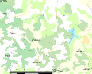
Labescau
- commune in Gironde, France
- Country:
- Postal Code: 33690
- Coordinates: 44° 26' 39" N, 0° 5' 20" E
- GPS tracks (wikiloc): [Link]
- Area: 5.99 sq km
- Population: 105
- Web site: [Link]


Bazas
- commune in Gironde, France
- Country:
- Postal Code: 33430
- Coordinates: 44° 25' 55" N, 0° 12' 42" E
- GPS tracks (wikiloc): [Link]
- Area: 37.29 sq km
- Population: 4734
- Web site: [Link]


Lados
- commune in Gironde, France
- Country:
- Postal Code: 33124
- Coordinates: 44° 28' 3" N, 0° 8' 51" E
- GPS tracks (wikiloc): [Link]
- Area: 6.49 sq km
- Population: 173