Bazas (Bazas)

- commune in Gironde, France
- Country:

- Postal Code: 33430
- Coordinates: 44° 25' 55" N, 0° 12' 42" E


- GPS tracks (wikiloc): [Link]
- Area: 37.29 sq km
- Population: 4734
- Web site: http://www.ville-bazas.fr
- Wikipedia en: wiki(en)
- Wikipedia: wiki(fr)
- Wikidata storage: Wikidata: Q208427
- Wikipedia Commons Category: [Link]
- Freebase ID: [/m/08t0qm]
- GeoNames ID: Alt: [3034458]
- SIREN number: [213300361]
- BnF ID: [15256090g]
- VIAF ID: Alt: [136739165]
- GND ID: Alt: [4225392-5]
- Library of Congress authority ID: Alt: [n85324673]
- MusicBrainz area ID: [227eab90-d80a-44df-a2db-6e0e6015c85f]
- Digital Atlas of the Roman Empire ID: [148]
- INSEE municipality code: 33036
Shares border with regions:


Marimbault
- commune in Gironde, France
- Country:
- Postal Code: 33430
- Coordinates: 44° 24' 37" N, 0° 16' 7" E
- GPS tracks (wikiloc): [Link]
- Area: 6.71 sq km
- Population: 191
- Web site: [Link]

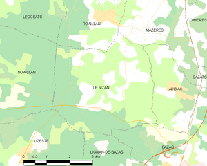
Le Nizan
- commune in Gironde, France
- Country:
- Postal Code: 33430
- Coordinates: 44° 28' 39" N, 0° 16' 11" E
- GPS tracks (wikiloc): [Link]
- Area: 15.21 sq km
- Population: 496
- Web site: [Link]

Gans
- commune in Gironde, France
- Country:
- Postal Code: 33430
- Coordinates: 44° 27' 20" N, 0° 8' 48" E
- GPS tracks (wikiloc): [Link]
- Area: 7.01 sq km
- Population: 189
- Web site: [Link]


Lignan-de-Bazas
- commune in Gironde, France
- Country:
- Postal Code: 33430
- Coordinates: 44° 25' 52" N, 0° 16' 43" E
- GPS tracks (wikiloc): [Link]
- Area: 11.1 sq km
- Population: 381
- Web site: [Link]


Sauviac
- commune in Gironde, France
- Country:
- Postal Code: 33430
- Coordinates: 44° 24' 20" N, 0° 11' 10" E
- GPS tracks (wikiloc): [Link]
- Area: 11.15 sq km
- Population: 316
- Web site: [Link]


Gajac
- commune in Gironde, France
- Country:
- Postal Code: 33430
- Coordinates: 44° 26' 15" N, 0° 7' 30" E
- GPS tracks (wikiloc): [Link]
- Area: 12.28 sq km
- Population: 386
- Web site: [Link]

Aubiac
- commune in Gironde, France
- Country:
- Postal Code: 33430
- Coordinates: 44° 28' 10" N, 0° 14' 29" E
- GPS tracks (wikiloc): [Link]
- Area: 5.62 sq km
- Population: 276
- Web site: [Link]


Brouqueyran
- commune in Gironde, France
- Country:
- Postal Code: 33124
- Coordinates: 44° 29' 2" N, 0° 10' 30" E
- GPS tracks (wikiloc): [Link]
- Area: 5.66 sq km
- Population: 198
- Web site: [Link]


Saint-Côme
- commune in Gironde, France
- Country:
- Postal Code: 33430
- Coordinates: 44° 25' 33" N, 0° 10' 51" E
- GPS tracks (wikiloc): [Link]
- AboveSeaLevel: 50 м m
- Area: 5.96 sq km
- Population: 318
- Web site: [Link]


Cazats
- commune in Gironde, France
- Country:
- Postal Code: 33430
- Coordinates: 44° 28' 18" N, 0° 12' 28" E
- GPS tracks (wikiloc): [Link]
- Area: 7.48 sq km
- Population: 410
- Web site: [Link]


Lados
- commune in Gironde, France
- Country:
- Postal Code: 33124
- Coordinates: 44° 28' 3" N, 0° 8' 51" E
- GPS tracks (wikiloc): [Link]
- Area: 6.49 sq km
- Population: 173


Cudos
- commune in Gironde, France
- Country:
- Postal Code: 33430
- Coordinates: 44° 23' 20" N, 0° 13' 10" E
- GPS tracks (wikiloc): [Link]
- Area: 34.21 sq km
- Population: 817
- Web site: [Link]