Gathemo (Gathemo)

- commune in Manche, France
- Country:

- Postal Code: 50150
- Coordinates: 48° 45' 55" N, 0° 58' 33" E


- GPS tracks (wikiloc): [Link]
- Area: 10.41 sq km
- Population: 242
- Wikipedia en: wiki(en)
- Wikipedia: wiki(fr)
- Wikidata storage: Wikidata: Q1071511
- Wikipedia Commons Category: [Link]
- Freebase ID: [/m/03w9lr4]
- Freebase ID: [/m/03w9lr4]
- GeoNames ID: Alt: [6435412]
- GeoNames ID: Alt: [6435412]
- SIREN number: [215001959]
- SIREN number: [215001959]
- BnF ID: [152621722]
- BnF ID: [152621722]
- INSEE municipality code: 50195
- INSEE municipality code: 50195
Shares border with regions:

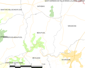
Beauficel
- commune in Manche, France
- Country:
- Postal Code: 50150
- Coordinates: 48° 44' 24" N, 0° 57' 37" E
- GPS tracks (wikiloc): [Link]
- Area: 9.13 sq km
- Population: 153


Saint-Michel-de-Montjoie
- commune in Manche, France
- Country:
- Postal Code: 50670
- Coordinates: 48° 45' 48" N, 1° 1' 39" E
- GPS tracks (wikiloc): [Link]
- Area: 14.46 sq km
- Population: 320


Sourdeval
- commune in Manche, France
- Country:
- Postal Code: 50150
- Coordinates: 48° 43' 24" N, 0° 55' 15" E
- GPS tracks (wikiloc): [Link]
- Area: 36.12 sq km
- Population: 2690
- Web site: [Link]


Champ-du-Boult
- former commune in Calvados, France
- Country:
- Postal Code: 14380
- Coordinates: 48° 47' 35" N, 1° 0' 29" E
- GPS tracks (wikiloc): [Link]
- Area: 13.85 sq km
- Population: 372
- Web site: [Link]


Perriers-en-Beauficel
- commune in Manche, France
- Country:
- Postal Code: 50150
- Coordinates: 48° 44' 13" N, 0° 59' 48" E
- GPS tracks (wikiloc): [Link]
- Area: 9.3 sq km
- Population: 216