Gazeran (Gazeran)

- commune in Yvelines, France
- Country:

- Postal Code: 78125
- Coordinates: 48° 38' 2" N, 1° 46' 25" E


- GPS tracks (wikiloc): [Link]
- Area: 25.8 sq km
- Population: 1287
- Web site: http://www.commune-gazeran.fr
- Wikipedia en: wiki(en)
- Wikipedia: wiki(fr)
- Wikidata storage: Wikidata: Q246326
- Wikipedia Commons Category: [Link]
- Freebase ID: [/m/03qgdwl]
- Freebase ID: [/m/03qgdwl]
- GeoNames ID: Alt: [3016456]
- GeoNames ID: Alt: [3016456]
- SIREN number: [217802693]
- SIREN number: [217802693]
- BnF ID: [15275973j]
- BnF ID: [15275973j]
- TGN ID: [1033250]
- TGN ID: [1033250]
- INSEE municipality code: 78269
- INSEE municipality code: 78269
Shares border with regions:


Poigny-la-Forêt
- commune in Yvelines, France
- Country:
- Postal Code: 78125
- Coordinates: 48° 40' 40" N, 1° 45' 13" E
- GPS tracks (wikiloc): [Link]
- Area: 23.27 sq km
- Population: 966
- Web site: [Link]

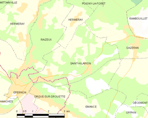
Saint-Hilarion
- commune in Yvelines, France
- Country:
- Postal Code: 78125
- Coordinates: 48° 37' 13" N, 1° 44' 0" E
- GPS tracks (wikiloc): [Link]
- Area: 14 sq km
- Population: 894
- Web site: [Link]

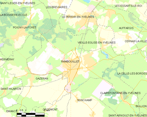
Rambouillet
- commune in Yvelines, France
- Country:
- Postal Code: 78120
- Coordinates: 48° 38' 37" N, 1° 49' 48" E
- GPS tracks (wikiloc): [Link]
- AboveSeaLevel: 142 м m
- Area: 35.19 sq km
- Population: 25456
- Web site: [Link]


Orcemont
- commune in Yvelines, France
- Country:
- Postal Code: 78125
- Coordinates: 48° 35' 17" N, 1° 48' 38" E
- GPS tracks (wikiloc): [Link]
- Area: 10.49 sq km
- Population: 948
- Web site: [Link]


Orphin
- commune in Yvelines, France
- Country:
- Postal Code: 78125
- Coordinates: 48° 34' 43" N, 1° 46' 52" E
- GPS tracks (wikiloc): [Link]
- Area: 16.5 sq km
- Population: 898
- Web site: [Link]


Émancé
- commune in Yvelines, France
- Country:
- Postal Code: 78125
- Coordinates: 48° 35' 25" N, 1° 43' 48" E
- GPS tracks (wikiloc): [Link]
- Area: 11.99 sq km
- Population: 879
- Web site: [Link]

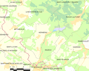
Hermeray
- commune in Yvelines, France
- Country:
- Postal Code: 78125
- Coordinates: 48° 39' 0" N, 1° 41' 17" E
- GPS tracks (wikiloc): [Link]
- AboveSeaLevel: 134 м m
- Area: 18.07 sq km
- Population: 954