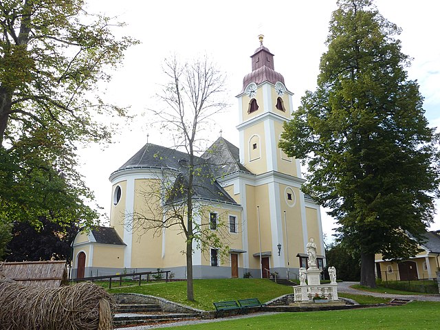
Gföhl (Gföhl)
- municipality in Austria
Gföhl, located in the beautiful state of Lower Austria, is a charming area that offers various hiking opportunities, especially for those who appreciate picturesque landscapes and serene nature. Here are some key points to consider if you're planning a hiking trip in Gföhl:
Scenic Trails
-
Nature Trails: Gföhl offers several well-marked trails that range from easy strolls to moderate hikes. The routes often provide stunning views of the surrounding vineyards and hills.
-
Awareness of Local Flora and Fauna: The region is rich in biodiversity, so hikers have the chance to observe local wildlife and native plant species along the trails.
Recommended Hikes
- Gföhl Loop Trail: A lovely loop that allows you to explore the area around Gföhl, featuring picturesque views and a mix of forest and open landscapes.
- Danube Trail: Not far from Gföhl, you can access parts of the famous Danube Trail, which runs alongside the river and provides stunning views.
Difficulty Levels
- The trails around Gföhl range in difficulty, making them suitable for families, casual hikers, and more seasoned adventurers. Ensure that you choose a trail that matches your fitness level.
Best Time to Visit
- The best time for hiking in this region is typically during the spring and early autumn months when the weather is mild and the natural scenery is in full bloom or displaying autumn colors.
Preparation Tips
- Proper Footwear: Good hiking boots are essential for comfort and safety.
- Weather Check: Always check the weather forecast before heading out, as conditions can change quickly.
- Hydration and Snacks: Carry enough water and some snacks to keep your energy up during your hike.
Local Facilities
- Gföhl offers some amenities, such as local eateries where you can enjoy traditional Austrian cuisine after your hike. Consider trying out local wines, as the region is known for its vineyards.
Cultural Aspects
- While hiking, take the opportunity to appreciate the local culture and history of Gföhl. You may find historical landmarks or charming villages along the trails.
Overall, Gföhl is a great destination for hikers looking to enjoy peaceful surroundings, beautiful landscapes, and a touch of local culture. Happy hiking!
- Country:

- Postal Code: 3542
- Local Dialing Code: 02716
- Licence Plate Code: KR
- Coordinates: 48° 31' 0" N, 15° 29' 0" E


- GPS tracks (wikiloc): [Link]
- AboveSeaLevel: 579 м m
- Area: 80.75 sq km
- Population: 3783
- Web site: http://www.gfoehl.at
- Wikipedia en: wiki(en)
- Wikipedia: wiki(de)
- Wikidata storage: Wikidata: Q871624
- Wikipedia Commons Category: [Link]
- Freebase ID: [/m/02qxchg]
- GeoNames ID: Alt: [2778599]
- VIAF ID: Alt: [137674929]
- GND ID: Alt: [4093462-7]
- archINFORM location ID: [10072]
- Library of Congress authority ID: Alt: [nr2005001569]
- Austrian municipality key: [31311]
Shares border with regions:

Droß
- municipality in Austria
Droß, a quaint village nestled in the scenic landscape of Austria, is an excellent destination for hiking enthusiasts. Its proximity to both the foothills of the Alps and beautiful valleys provides various hiking trails that cater to different skill levels....
- Country:

- Postal Code: 3552
- Local Dialing Code: 02719
- Licence Plate Code: KR
- Coordinates: 48° 27' 0" N, 15° 34' 0" E


- GPS tracks (wikiloc): [Link]
- AboveSeaLevel: 394 м m
- Area: 10.3 sq km
- Population: 983
- Web site: [Link]

Weinzierl am Walde
- municipality in Austria
Weinzierl am Walde, nestled in the picturesque region of Austria, offers a variety of hiking opportunities that cater to both beginners and experienced hikers. Here’s what you can expect when hiking in this area:...
- Country:

- Postal Code: 3521
- Local Dialing Code: 02717
- Licence Plate Code: KR
- Coordinates: 48° 25' 0" N, 15° 26' 0" E


- GPS tracks (wikiloc): [Link]
- AboveSeaLevel: 647 м m
- Area: 44.55 sq km
- Population: 1240
- Web site: [Link]

Albrechtsberg an der Großen Krems
- municipality in Austria
 Hiking in Albrechtsberg an der Großen Krems
Albrechtsberg an der Großen Krems is a charming village located in the picturesque Wachau Valley of Austria, known for its rich cultural heritage, beautiful landscapes, and excellent hiking opportunities. Here’s a guide to hiking in the area:...
- Country:

- Postal Code: 3613
- Local Dialing Code: 02876
- Licence Plate Code: KR
- Coordinates: 48° 27' 50" N, 15° 22' 8" E


- GPS tracks (wikiloc): [Link]
- AboveSeaLevel: 686 м m
- Area: 28.72 sq km
- Population: 1036
- Web site: [Link]


Rastenfeld
- municipality in Austria
Rastenfeld, located in the beautiful Waldviertel region of Austria, offers a variety of hiking opportunities for outdoor enthusiasts. The area is known for its stunning landscapes, picturesque villages, and abundant nature, making it an ideal destination for both casual hikers and those seeking more challenging trails....
- Country:

- Postal Code: 3532
- Local Dialing Code: 02826
- Licence Plate Code: KR
- Coordinates: 48° 34' 0" N, 15° 19' 0" E


- GPS tracks (wikiloc): [Link]
- AboveSeaLevel: 579 м m
- Area: 47.55 sq km
- Population: 1551
- Web site: [Link]

Langenlois
- municipality in Austria
Langenlois, located in the beautiful wine region of Lower Austria, offers an array of hiking opportunities that allow visitors to explore its picturesque landscapes, vineyards, and charming villages. Here are some highlights of hiking in and around Langenlois:...
- Country:

- Postal Code: 3550
- Local Dialing Code: 02734
- Licence Plate Code: KR
- Coordinates: 48° 28' 0" N, 15° 41' 0" E


- GPS tracks (wikiloc): [Link]
- AboveSeaLevel: 219 м m
- Area: 67.12 sq km
- Population: 7609
- Web site: [Link]

Lichtenau im Waldviertel
- municipality in Austria
 Hiking in Lichtenau im Waldviertel
Lichtenau im Waldviertel is a charming area in Austria's Waldviertel region, known for its beautiful landscapes, rolling hills, and dense forests, making it a great destination for hiking enthusiasts. Here are some key points to consider:...
- Country:

- Postal Code: 3522
- Local Dialing Code: 02718
- Licence Plate Code: KR
- Coordinates: 48° 30' 0" N, 15° 23' 0" E


- GPS tracks (wikiloc): [Link]
- AboveSeaLevel: 639 м m
- Area: 58.36 sq km
- Population: 2049
- Web site: [Link]

Jaidhof
- municipality in Austria
Jaidhof, a picturesque region in Austria, is known for its beautiful landscapes and tranquil hiking trails. Nestled in the foothills of the Alps, this area offers a variety of hiking experiences suitable for different skill levels. Here are some highlights for those interested in hiking in Jaidhof:...
- Country:

- Postal Code: 3542
- Local Dialing Code: 02716
- Licence Plate Code: KR
- Coordinates: 48° 32' 0" N, 15° 29' 0" E


- GPS tracks (wikiloc): [Link]
- AboveSeaLevel: 592 м m
- Area: 44.93 sq km
- Population: 1225
- Web site: [Link]

Lengenfeld
- municipality in Austria
Lengenfeld, located in the beautiful landscapes of Austria, is an excellent destination for hiking enthusiasts. Nestled in the region of Styria, Lengenfeld offers a mix of alpine scenery, lush valleys, and diverse flora and fauna. Here are some highlights and considerations for hiking in Lengenfeld:...
- Country:

- Postal Code: 3552
- Local Dialing Code: 02719
- Licence Plate Code: KR
- Coordinates: 48° 28' 0" N, 15° 35' 0" E


- GPS tracks (wikiloc): [Link]
- AboveSeaLevel: 315 м m
- Area: 15.01 sq km
- Population: 1412
- Web site: [Link]