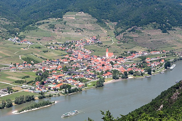
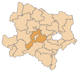
Krems-Land District (Bezirk Krems)

- district of Austria
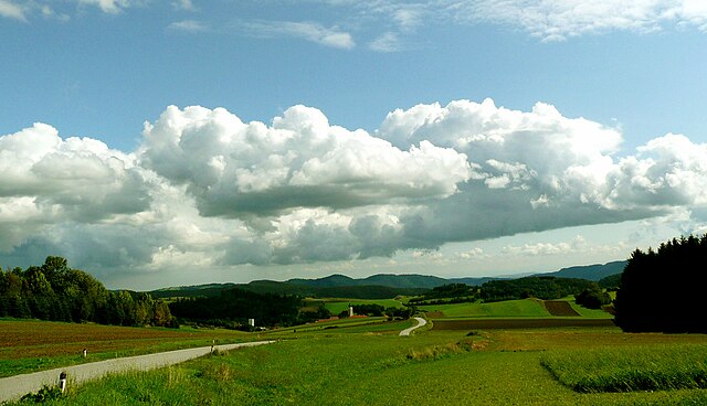
 Hiking in Krems-Land District
Krems-Land District, located in the foothills of the Austrian Alps and close to the picturesque Wachau Valley, offers a variety of hiking opportunities for outdoor enthusiasts. Here are some key points about hiking in this beautiful region:
Scenic Trails
-
Diverse Landscapes: The district features a mix of vineyards, rolling hills, and forested areas, making every hike a unique experience. The proximity to the Danube River also offers stunning views and a chance to explore riverside paths.
-
Wachau World Heritage Site: Many trails lead through the Wachau Valley, which is known for its rich history, charming villages, and terraced vineyards. The area is a UNESCO World Heritage Site, so hikers can enjoy both natural beauty and cultural heritage.
-
Variety of Trails: There are trails suitable for all skill levels, from leisurely walks through vineyards to more challenging hikes in the nearby hills. Popular trails include the Wachau World Heritage Trail, which runs between Krems and Melk.
Hiking Tips
-
Weather Considerations: Always check the weather before heading out, as conditions can change rapidly, especially in higher elevations.
-
Footwear and Gear: Invest in a good pair of hiking shoes, and carry essentials like water, snacks, a map or GPS, and a first aid kit.
-
Local Resources: Consider visiting the tourist information center in Krems for maps, trail recommendations, and updates on trail conditions.
Additional Activities
- Wine Tasting: Many hikes pass through vineyard areas, and you may find opportunities to stop and taste local wines.
- Cultural Stops: Incorporate visits to historical sites, such as castles and abbeys, along your hiking route to enrich your experience.
Accessibility
The trails in Krems-Land are often well-marked, making them accessible for families and novice hikers. Public transport options are also available to reach starting points for various hikes.
Whether you're trekking through lush vineyards or exploring the serene riverbanks, Krems-Land District provides a wonderful setting for hiking and enjoying the great outdoors. Always respect nature and follow local regulations to help preserve this beautiful area for future visitors.
- Country:

- Licence Plate Code: KR
- Coordinates: 48° 27' 0" N, 15° 34' 1" E


- GPS tracks (wikiloc): [Link]
- Area: 923.95 sq km
- Wikipedia en: wiki(en)
- Wikipedia: wiki(de)
- Wikidata storage: Wikidata: Q694399
- Wikipedia Commons Category: [Link]
- Freebase ID: [/m/0flb98]
- GeoNames ID: Alt: [2773548]
- GND ID: Alt: [4546793-6]
- archINFORM location ID: [14632]
Includes regions:

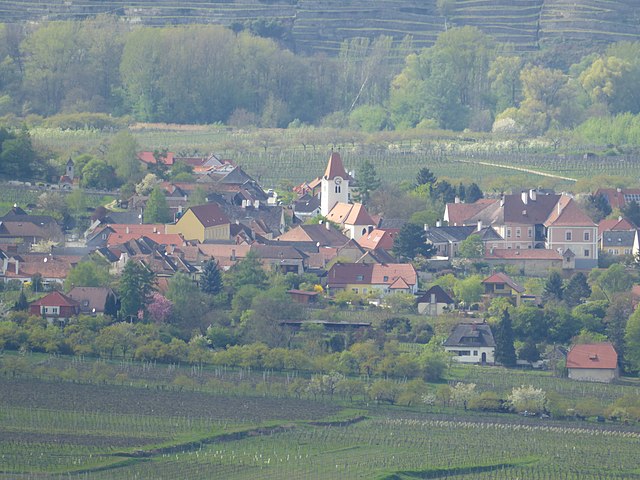
Droß
- municipality in Austria
Hiking in Droß
Droß, a quaint village nestled in the scenic landscape of Austria, is an excellent destination for hiking enthusiasts. Its proximity to both the foothills of the Alps and beautiful valleys provides various hiking trails that cater to different skill levels....
- Country:
- Postal Code: 3552
- Local Dialing Code: 02719
- Licence Plate Code: KR
- Coordinates: 48° 27' 0" N, 15° 34' 0" E
- GPS tracks (wikiloc): [Link]
- AboveSeaLevel: 394 м m
- Area: 10.3 sq km
- Population: 983
- Web site: [Link]
Aggsbach
- municipality in Austria
Hiking in Aggsbach
Aggsbach is a picturesque area located in Austria, known for its stunning natural landscapes along the Danube River. While specific hiking trails may vary, there are generally several options available for different skill levels. Here are some highlights you might want to consider when planning your hiking trip in Aggsbach:...
- Country:
- Local Dialing Code: 02712
- Licence Plate Code: KR
- Coordinates: 48° 17' 0" N, 15° 24' 0" E
- GPS tracks (wikiloc): [Link]
- AboveSeaLevel: 214 м m
- Area: 13.72 sq km
- Population: 643

Weinzierl am Walde
- municipality in Austria
Hiking in Weinzierl am Walde
Weinzierl am Walde, nestled in the picturesque region of Austria, offers a variety of hiking opportunities that cater to both beginners and experienced hikers. Here’s what you can expect when hiking in this area:...
- Country:
- Postal Code: 3521
- Local Dialing Code: 02717
- Licence Plate Code: KR
- Coordinates: 48° 25' 0" N, 15° 26' 0" E
- GPS tracks (wikiloc): [Link]
- AboveSeaLevel: 647 м m
- Area: 44.55 sq km
- Population: 1240
- Web site: [Link]

Gedersdorf
- municipality in Austria
Hiking in Gedersdorf
Gedersdorf is located in the beautiful region of Lower Austria, not far from the city of Krems and the picturesque Wachau Valley. This area is known for its scenic landscapes, including vineyards, rolling hills, and charming villages, making it a wonderful destination for hiking enthusiasts....
- Country:
- Postal Code: 3494
- Local Dialing Code: 02735
- Licence Plate Code: KR
- Coordinates: 48° 26' 1" N, 15° 41' 14" E
- GPS tracks (wikiloc): [Link]
- AboveSeaLevel: 194 м m
- Area: 18.87 sq km
- Population: 2184
- Web site: [Link]

Furth bei Göttweig
- municipality in Austria
Hiking in Furth bei Göttweig
Furth bei Göttweig is a picturesque village located in the Lower Austria region, known for its beautiful landscapes, vineyards, and historic sites. Hiking in this area provides a wonderful opportunity to explore the natural beauty and cultural heritage of Austria....
- Country:
- Postal Code: 3511
- Local Dialing Code: 02732
- Licence Plate Code: KR
- Coordinates: 48° 22' 0" N, 15° 36' 0" E
- GPS tracks (wikiloc): [Link]
- AboveSeaLevel: 214 м m
- Area: 12.37 sq km
- Population: 2956
- Web site: [Link]

Hadersdorf-Kammern
- municipality in Austria
Hiking in Hadersdorf-Kammern
Hadersdorf-Kammern is a quaint village in Austria, surrounded by beautiful natural landscapes that make it a great spot for hiking enthusiasts. Located in the Lower Austria region, it offers a variety of trails suitable for different skill levels....
- Country:
- Postal Code: 3493
- Local Dialing Code: 02735
- Licence Plate Code: KR
- Coordinates: 48° 27' 21" N, 15° 43' 14" E
- GPS tracks (wikiloc): [Link]
- AboveSeaLevel: 202 м m
- Area: 4.8 sq km
- Population: 2009
- Web site: [Link]

Grafenegg
- municipality in Austria
Hiking in Grafenegg
Grafenegg, located in Austria, is renowned for its picturesque landscapes, charming vineyards, and historical sites, making it an appealing destination for hiking enthusiasts. The area offers a variety of trails suited for different skill levels, from leisurely walks to more challenging hikes....
- Country:
- Postal Code: 3492
- Local Dialing Code: 02735
- Licence Plate Code: KR
- Coordinates: 48° 25' 48" N, 15° 44' 51" E
- GPS tracks (wikiloc): [Link]
- AboveSeaLevel: 197 м m
- Area: 28.58 sq km
- Population: 3061
- Web site: [Link]

Albrechtsberg an der Großen Krems
- municipality in Austria
Hiking in Albrechtsberg an der Großen Krems
Albrechtsberg an der Großen Krems is a charming village located in the picturesque Wachau Valley of Austria, known for its rich cultural heritage, beautiful landscapes, and excellent hiking opportunities. Here’s a guide to hiking in the area:...
- Country:
- Postal Code: 3613
- Local Dialing Code: 02876
- Licence Plate Code: KR
- Coordinates: 48° 27' 50" N, 15° 22' 8" E
- GPS tracks (wikiloc): [Link]
- AboveSeaLevel: 686 м m
- Area: 28.72 sq km
- Population: 1036
- Web site: [Link]

Sankt Leonhard am Hornerwald
- municipality in Austria
Hiking in Sankt Leonhard am Hornerwald
Sankt Leonhard am Hornerwald is a charming village in Lower Austria, known for its beautiful landscapes and scenic hiking opportunities. This region offers a variety of trails that cater to different skill levels and preferences, making it an excellent destination for both casual hikers and seasoned trekkers....
- Country:
- Postal Code: 3572
- Local Dialing Code: 02987
- Licence Plate Code: KR
- Coordinates: 48° 35' 0" N, 15° 32' 0" E
- GPS tracks (wikiloc): [Link]
- AboveSeaLevel: 582 м m
- Area: 51.57 sq km
- Population: 1119
- Web site: [Link]

Paudorf
- municipality in Austria
Hiking in Paudorf
Paudorf, a small municipality located in Lower Austria, offers a scenic backdrop for hiking enthusiasts. The region is characterized by its rolling hills, vineyards, and beautiful landscapes, making it an appealing destination for both casual walkers and more serious hikers....
- Country:
- Postal Code: 3508
- Local Dialing Code: 02736
- Licence Plate Code: KR
- Coordinates: 48° 21' 0" N, 15° 37' 0" E
- GPS tracks (wikiloc): [Link]
- AboveSeaLevel: 257 м m
- Area: 30.09 sq km
- Population: 2598
- Web site: [Link]


Rastenfeld
- municipality in Austria
Hiking in Rastenfeld
Rastenfeld, located in the beautiful Waldviertel region of Austria, offers a variety of hiking opportunities for outdoor enthusiasts. The area is known for its stunning landscapes, picturesque villages, and abundant nature, making it an ideal destination for both casual hikers and those seeking more challenging trails....
- Country:
- Postal Code: 3532
- Local Dialing Code: 02826
- Licence Plate Code: KR
- Coordinates: 48° 34' 0" N, 15° 19' 0" E
- GPS tracks (wikiloc): [Link]
- AboveSeaLevel: 579 м m
- Area: 47.55 sq km
- Population: 1551
- Web site: [Link]
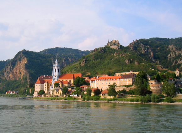

Dürnstein
- municipality in Austria
Hiking in Dürnstein
Dürnstein is a charming village located in the Wachau Valley of Austria, known for its picturesque landscapes, vineyards, and historical sites. Hiking in and around Dürnstein offers stunning views of the Danube River, lush hillsides, and beautiful terraced vineyards....
- Country:
- Postal Code: 3601
- Local Dialing Code: 02711
- Licence Plate Code: KR
- Coordinates: 48° 23' 44" N, 15° 31' 13" E
- GPS tracks (wikiloc): [Link]
- AboveSeaLevel: 209 м m
- Area: 16.81 sq km
- Population: 864
- Web site: [Link]

Mautern an der Donau
- municipality in Austria
Hiking in Mautern an der Donau
Mautern an der Donau, located in Austria in the region of Lower Austria, is a charming village that offers various hiking opportunities with stunning views of the Danube River and the surrounding landscape. Here are some highlights about hiking in this area:...
- Country:
- Postal Code: 3512
- Local Dialing Code: 02732
- Licence Plate Code: KR
- Coordinates: 48° 23' 37" N, 15° 34' 39" E
- GPS tracks (wikiloc): [Link]
- AboveSeaLevel: 201 м m
- Area: 9.14 sq km
- Population: 3567
- Web site: [Link]

Langenlois
- municipality in Austria
Hiking in Langenlois
Langenlois, located in the beautiful wine region of Lower Austria, offers an array of hiking opportunities that allow visitors to explore its picturesque landscapes, vineyards, and charming villages. Here are some highlights of hiking in and around Langenlois:...
- Country:
- Postal Code: 3550
- Local Dialing Code: 02734
- Licence Plate Code: KR
- Coordinates: 48° 28' 0" N, 15° 41' 0" E
- GPS tracks (wikiloc): [Link]
- AboveSeaLevel: 219 м m
- Area: 67.12 sq km
- Population: 7609
- Web site: [Link]

Krumau am Kamp
- municipality in Austria
Hiking in Krumau am Kamp
Krumau am Kamp, a picturesque village located in Austria's Lower Austria region, is an excellent destination for hiking enthusiasts. The area is known for its stunning natural beauty, featuring rolling hills, vineyards, and the scenic Kamp River. Here are some aspects to consider when hiking in and around Krumau am Kamp:...
- Country:
- Postal Code: 3543
- Local Dialing Code: 02731
- Licence Plate Code: KR
- Coordinates: 48° 35' 0" N, 15° 26' 0" E
- GPS tracks (wikiloc): [Link]
- AboveSeaLevel: 370 м m
- Area: 26.84 sq km
- Population: 759
- Web site: [Link]

Straß im Straßertale
- municipality in Austria
Hiking in Straß im Straßertale
Straß im Straßertale, located in Austria's beautiful wine country in Lower Austria, is an excellent destination for hiking enthusiasts. Nestled in the rolling hills and vineyards, it offers various scenic trails that cater to different skill levels. Here are some highlights about hiking in this area:...
- Country:
- Postal Code: 3491
- Local Dialing Code: 02735
- Licence Plate Code: KR
- Coordinates: 48° 28' 0" N, 15° 44' 0" E
- GPS tracks (wikiloc): [Link]
- AboveSeaLevel: 217 м m
- Area: 22.49 sq km
- Population: 1678
- Web site: [Link]
Lichtenau im Waldviertel
- municipality in Austria
Hiking in Lichtenau im Waldviertel
Lichtenau im Waldviertel is a charming area in Austria's Waldviertel region, known for its beautiful landscapes, rolling hills, and dense forests, making it a great destination for hiking enthusiasts. Here are some key points to consider:...
- Country:
- Postal Code: 3522
- Local Dialing Code: 02718
- Licence Plate Code: KR
- Coordinates: 48° 30' 0" N, 15° 23' 0" E
- GPS tracks (wikiloc): [Link]
- AboveSeaLevel: 639 м m
- Area: 58.36 sq km
- Population: 2049
- Web site: [Link]


Maria Laach am Jauerling
- municipality in Austria
Hiking in Maria Laach am Jauerling
Maria Laach am Jauerling, located in the picturesque region of Lower Austria, offers a variety of hiking opportunities that showcase the area's natural beauty and cultural heritage. Here are some aspects of hiking in this region:...
- Country:
- Postal Code: 3643
- Local Dialing Code: 02712
- Licence Plate Code: KR
- Coordinates: 48° 18' 11" N, 15° 20' 42" E
- GPS tracks (wikiloc): [Link]
- AboveSeaLevel: 591 м m
- Area: 36.44 sq km
- Population: 916
- Web site: [Link]

Rohrendorf bei Krems
- municipality in Austria
Hiking in Rohrendorf bei Krems
Rohrendorf bei Krems is a picturesque village located in the Krems-Land district of Austria's Lower Austria region. Nestled along the banks of the Danube River near the Wachau Valley, it offers an array of hiking opportunities that showcase the beautiful landscapes, vineyards, and historic sites that characterize this area....
- Country:
- Postal Code: 3495
- Local Dialing Code: 02732
- Licence Plate Code: KR
- Coordinates: 48° 25' 0" N, 15° 39' 0" E
- GPS tracks (wikiloc): [Link]
- AboveSeaLevel: 194 м m
- Area: 9.78 sq km
- Population: 2091
- Web site: [Link]

Bergern im Dunkelsteinerwald
- municipality in Austria
Hiking in Bergern im Dunkelsteinerwald
Bergern im Dunkelsteinerwald is a charming destination for hiking enthusiasts, located in Austria's Lower Austria region. The Dunkelsteinerwald itself is a picturesque forested area characterized by a mix of deciduous and coniferous trees, hills, and valleys, providing a beautiful backdrop for various outdoor activities. Here are some highlights to consider when planning your hiking adventure in this area:...
- Country:
- Postal Code: 3512
- Local Dialing Code: 02714
- Licence Plate Code: KR
- Coordinates: 48° 22' 0" N, 15° 33' 0" E
- GPS tracks (wikiloc): [Link]
- AboveSeaLevel: 305 м m
- Area: 36.53 sq km
- Population: 1253
- Web site: [Link]
Jaidhof
- municipality in Austria
Hiking in Jaidhof
Jaidhof, a picturesque region in Austria, is known for its beautiful landscapes and tranquil hiking trails. Nestled in the foothills of the Alps, this area offers a variety of hiking experiences suitable for different skill levels. Here are some highlights for those interested in hiking in Jaidhof:...
- Country:
- Postal Code: 3542
- Local Dialing Code: 02716
- Licence Plate Code: KR
- Coordinates: 48° 32' 0" N, 15° 29' 0" E
- GPS tracks (wikiloc): [Link]
- AboveSeaLevel: 592 м m
- Area: 44.93 sq km
- Population: 1225
- Web site: [Link]
Weißenkirchen in der Wachau
- municipality in Austria
Hiking in Weißenkirchen in der Wachau
Weißenkirchen in der Wachau is a picturesque town located in the Wachau Valley region of Austria, known for its stunning landscapes, vineyards, and charming architecture. The area offers many hiking opportunities that cater to various skill levels. Here’s an overview of what you can expect when hiking in this beautiful region:...
- Country:
- Postal Code: 3610
- Local Dialing Code: 02715
- Licence Plate Code: KR
- Coordinates: 48° 23' 0" N, 15° 28' 0" E
- GPS tracks (wikiloc): [Link]
- AboveSeaLevel: 224 м m
- Area: 23.28 sq km
- Population: 1429
- Web site: [Link]

Spitz
- municipality in Austria
Hiking in Spitz
Spitz, Austria, is a charming village located in the Wachau Valley, renowned for its stunning scenery and rich cultural history. It is a popular destination for hiking enthusiasts owing to its picturesque landscapes, vineyards, and historic sites. Here are some highlights for hiking in the area:...
- Country:
- Postal Code: 3620
- Local Dialing Code: 02713
- Licence Plate Code: KR
- Coordinates: 48° 21' 0" N, 15° 25' 0" E
- GPS tracks (wikiloc): [Link]
- AboveSeaLevel: 223 м m
- Area: 23.83 sq km
- Population: 1620
- Web site: [Link]
Rossatz-Arnsdorf
- municipality in Austria
Hiking in Rossatz-Arnsdorf
Rossatz-Arnsdorf, located in the Wachau Valley of Austria, is a picturesque area known for its stunning landscapes, vineyards, and rich cultural heritage. Hiking in this region offers a variety of trails suitable for different skill levels, making it a great destination for nature enthusiasts and outdoor adventurers....
- Country:
- Local Dialing Code: 02714
- Licence Plate Code: KR
- Coordinates: 48° 23' 45" N, 15° 30' 15" E
- GPS tracks (wikiloc): [Link]
- AboveSeaLevel: 225 м m
- Area: 3904 sq km
- Population: 1065
- Web site: [Link]

Mühldorf, Lower Austria
- municipality in Lower Austria
Hiking in Mühldorf, Lower Austria
Mühldorf, located in Lower Austria, is surrounded by beautiful landscapes and offers a variety of hiking opportunities. The region is characterized by rolling hills, forests, and picturesque valleys, making it an ideal destination for both novice and experienced hikers....
- Country:
- Postal Code: 3622
- Local Dialing Code: 02713
- Licence Plate Code: KR
- Coordinates: 48° 22' 0" N, 15° 21' 0" E
- GPS tracks (wikiloc): [Link]
- AboveSeaLevel: 360 м m
- Area: 28.46 sq km
- Population: 1331
- Web site: [Link]

Stratzing
- municipality in Austria
Hiking in Stratzing
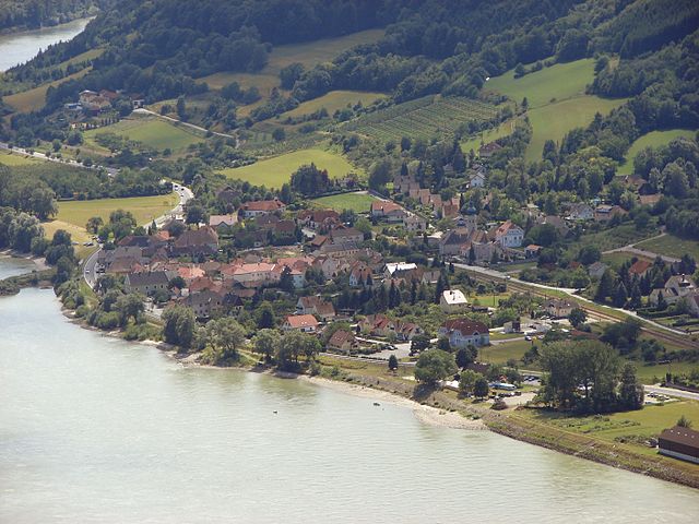
Stratzing is a charming village located in Austria, nestled within the beautiful landscape of the Wachau Valley. This region is renowned for its vineyards, rolling hills, and lovely riverside views along the Danube River. Hiking in Stratzing offers a unique blend of natural beauty and cultural experiences, making it a fantastic destination for outdoor enthusiasts....
- Country:
- Postal Code: 3552
- Local Dialing Code: 02719
- Licence Plate Code: KR
- Coordinates: 48° 27' 0" N, 15° 36' 0" E
- GPS tracks (wikiloc): [Link]
- AboveSeaLevel: 352 м m
- Area: 5.84 sq km
- Population: 827
- Web site: [Link]

Schönberg am Kamp
- municipality in Austria
Hiking in Schönberg am Kamp
Schönberg am Kamp, located in Lower Austria, is a charming destination for hiking enthusiasts. The area is characterized by its beautiful natural landscapes, rolling hills, and lush vineyards, making it an ideal spot for outdoor activities....
- Country:
- Local Dialing Code: 02733
- Licence Plate Code: KR
- Coordinates: 48° 31' 0" N, 15° 42' 0" E
- GPS tracks (wikiloc): [Link]
- AboveSeaLevel: 226 м m
- Area: 53.28 sq km
- Population: 1903
- Web site: [Link]

Senftenberg
- municipality in Austria
Hiking in Senftenberg
Senftenberg, located in the picturesque region of Lower Austria, is known for its stunning landscapes, beautiful vineyards, and scenic hiking trails. The area is part of the Wachau Valley, a UNESCO World Heritage Site, famous for its rolling hills, river views, and cultural heritage....
- Country:
- Postal Code: 3541
- Local Dialing Code: 02719
- Licence Plate Code: KR
- Coordinates: 48° 26' 0" N, 15° 33' 0" E
- GPS tracks (wikiloc): [Link]
- AboveSeaLevel: 254 м m
- Area: 34.76 sq km
- Population: 1977
- Web site: [Link]

Gföhl
- municipality in Austria
Hiking in Gföhl
Gföhl, located in the beautiful state of Lower Austria, is a charming area that offers various hiking opportunities, especially for those who appreciate picturesque landscapes and serene nature. Here are some key points to consider if you're planning a hiking trip in Gföhl:...
- Country:
- Postal Code: 3542
- Local Dialing Code: 02716
- Licence Plate Code: KR
- Coordinates: 48° 31' 0" N, 15° 29' 0" E
- GPS tracks (wikiloc): [Link]
- AboveSeaLevel: 579 м m
- Area: 80.75 sq km
- Population: 3783
- Web site: [Link]

Lengenfeld
- municipality in Austria
Hiking in Lengenfeld
Lengenfeld, located in the beautiful landscapes of Austria, is an excellent destination for hiking enthusiasts. Nestled in the region of Styria, Lengenfeld offers a mix of alpine scenery, lush valleys, and diverse flora and fauna. Here are some highlights and considerations for hiking in Lengenfeld:...
- Country:
- Postal Code: 3552
- Local Dialing Code: 02719
- Licence Plate Code: KR
- Coordinates: 48° 28' 0" N, 15° 35' 0" E
- GPS tracks (wikiloc): [Link]
- AboveSeaLevel: 315 м m
- Area: 15.01 sq km
- Population: 1412
- Web site: [Link]
Shares border with regions:

Sankt Pölten-Land District
- district of Austria
Hiking in Sankt Pölten-Land District
Sankt Pölten-Land District, located in the Lower Austria region of Austria, is a scenic area that offers numerous hiking opportunities amidst beautiful landscapes, cultural heritage, and nature reserves. Here are some highlights and tips for hiking in this district:...
- Country:
- Licence Plate Code: PL
- Coordinates: 48° 10' 59" N, 15° 40' 1" E
- GPS tracks (wikiloc): [Link]
- AboveSeaLevel: 313 м m
- Area: 1121.61 sq km
- Web site: [Link]

Tulln District
- district of Austria
Hiking in Tulln District
Tulln District, located in Lower Austria, offers a variety of hiking opportunities that showcase the region's stunning landscapes, rich history, and natural beauty. Here are some highlights and considerations for hiking in this area:...
- Country:
- Licence Plate Code: TU
- Coordinates: 48° 19' 48" N, 15° 58' 48" E
- GPS tracks (wikiloc): [Link]
- Area: 734.00 sq km
- Web site: [Link]

Zwettl District
- district of Austria
Hiking in Zwettl District
Zwettl District, located in the Waldviertel region of Austria, offers a picturesque setting for hiking enthusiasts. The area is characterized by its diverse landscapes, including forests, rolling hills, and charming villages, making it a great destination for both casual walkers and experienced hikers....
- Country:
- Licence Plate Code: ZT
- Coordinates: 48° 34' 52" N, 15° 9' 7" E
- GPS tracks (wikiloc): [Link]
- AboveSeaLevel: 665 м m
- Area: 1399.76 sq km
- Web site: [Link]