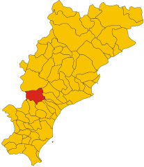
Giustenice (Giustenice)
.svg)
- Italian comune
 Hiking in Giustenice
Giustenice, a small town located in the Province of Savona in the Italian region of Liguria, offers a range of beautiful hiking opportunities. The surrounding landscapes feature rolling hills, olive groves, and Mediterranean vegetation, making it an excellent destination for nature enthusiasts and hikers.
Hiking Highlights in Giustenice:
-
Scenic Trails: The area is part of the larger Ligurian landscape, known for its stunning coastal views and picturesque inland paths. Many trails lead through olive plantations and vineyards, where you can enjoy the local flora and fauna.
-
Cultural Landmarks: While hiking, you’ll have the opportunity to discover local historical sites, such as old churches and traditional stone villages. Look for the unique architecture and the rich history embedded in the landscape.
-
Wildlife Observation: The biodiversity in this area is rich, and hikers may spot various bird species, small mammals, and unique Mediterranean plants along the trails.
-
Moderate Climate: The climate in Giustenice is typically mild, making it a suitable hiking destination in both spring and fall. Summer can be warm, so early morning or late afternoon hikes are ideal during that season.
Suggested Hiking Routes:
-
Trail to the Coast: One popular route leads from Giustenice down toward the coastline, where you can enjoy views of the Mediterranean Sea. This trail may connect to larger coastal paths that offer even more exploration.
-
Hikes to Nearby Villages: Hiking from Giustenice to nearby villages can also be rewarding, providing a taste of local life and the chance to indulge in some Ligurian cuisine at trattorias along the way.
-
Nature Reserves: Explore nearby nature reserves that preserve the unique landscape and ecosystem of the region. These areas often have well-marked trails with varying levels of difficulty.
Tips for Hikers:
- Footwear: Ensure you wear sturdy hiking boots for comfort and support, especially on uneven terrain.
- Supplies: Bring plenty of water, snacks, and a map or GPS device. Although trails are often well-marked, it’s good to be prepared.
- Respect the Environment: Follow Leave No Trace principles to protect the beautiful landscapes and ecosystems during your hike.
Overall, Giustenice is a wonderful spot for hiking, with its combination of natural beauty, cultural landmarks, and welcoming atmosphere. Enjoy your adventure!
- Country:

- Postal Code: 17027
- Local Dialing Code: 019
- Licence Plate Code: SV
- Coordinates: 44° 10' 20" N, 8° 14' 46" E


- GPS tracks (wikiloc): [Link]
- AboveSeaLevel: 140 м m
- Area: 17.22 sq km
- Population: 998
- Web site: http://www.comune.giustenice.sv.it
- Wikipedia en: wiki(en)
- Wikipedia: wiki(it)
- Wikidata storage: Wikidata: Q270752
- Wikipedia Commons Category: [Link]
- Freebase ID: [/m/0gbzs9]
- GeoNames ID: Alt: [6542746]
- VIAF ID: Alt: [255380383]
- OSM relation ID: [42931]
- ISTAT ID: 009031
- Italian cadastre code: E064
Shares border with regions:

Bardineto
- Italian comune
Hiking in Bardineto
Bardineto is a picturesque village located in the Liguria region of Italy, nestled within the lush countryside of the province of Savona. The area is characterized by its stunning natural landscapes, rolling hills, and mountainous terrain, making it an excellent destination for hiking enthusiasts....
- Country:
- Postal Code: 17057
- Local Dialing Code: 019
- Licence Plate Code: SV
- Coordinates: 44° 11' 32" N, 8° 7' 45" E
- GPS tracks (wikiloc): [Link]
- AboveSeaLevel: 711 м m
- Area: 29.79 sq km
- Population: 744
- Web site: [Link]

Loano
- Italian comune
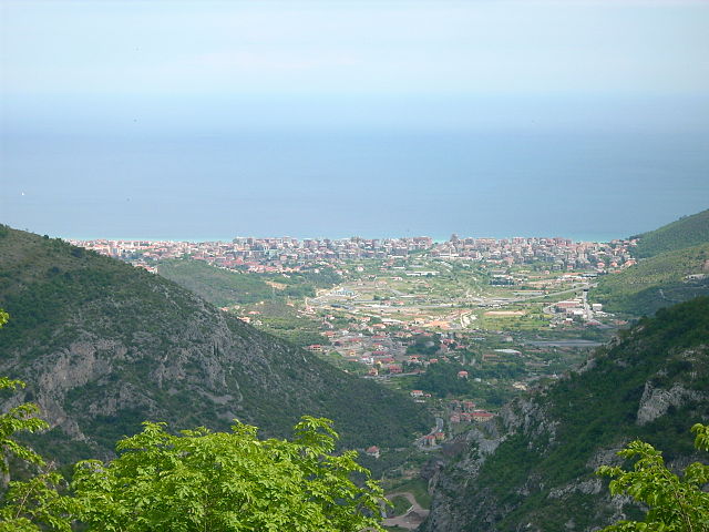
Hiking in Loano
Loano is a charming coastal town located on the Italian Riviera in the Liguria region. It offers a variety of hiking opportunities that cater to different skill levels and preferences. Here are some highlights of hiking in and around Loano:...
- Country:
- Postal Code: 17025
- Local Dialing Code: 019
- Licence Plate Code: SV
- Coordinates: 44° 7' 44" N, 8° 15' 35" E
- GPS tracks (wikiloc): [Link]
- AboveSeaLevel: 5 м m
- Area: 13.48 sq km
- Population: 11224
- Web site: [Link]


Magliolo
- Italian comune
Hiking in Magliolo
Magliolo is a charming village located in the Liguria region of Italy, nestled in the picturesque hills above the coastal town of Pietra Ligure. The surrounding area offers a variety of hiking opportunities, showcasing the natural beauty of the Italian Riviera....
- Country:
- Postal Code: 17020
- Local Dialing Code: 019
- Licence Plate Code: SV
- Coordinates: 44° 11' 30" N, 8° 15' 1" E
- GPS tracks (wikiloc): [Link]
- AboveSeaLevel: 270 м m
- Area: 19.57 sq km
- Population: 985
- Web site: [Link]

Pietra Ligure
- Italian comune
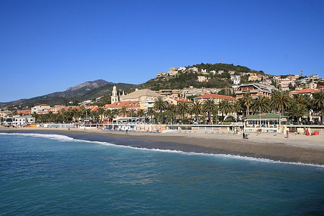
Hiking in Pietra Ligure
Pietra Ligure is a charming coastal town located in the Liguria region of northwest Italy, known for its beautiful beaches and picturesque landscapes. Hiking in and around Pietra Ligure offers stunning views of the Mediterranean Sea, lush vegetation, and the rugged terrain of the surrounding hills....
- Country:
- Postal Code: 17027
- Local Dialing Code: 019
- Licence Plate Code: SV
- Coordinates: 44° 8' 55" N, 8° 16' 58" E
- GPS tracks (wikiloc): [Link]
- AboveSeaLevel: 3 м m
- Area: 9.88 sq km
- Population: 8837
- Web site: [Link]


Tovo San Giacomo
- Italian comune
Hiking in Tovo San Giacomo
Tovo San Giacomo is a beautiful village located in the Liguria region of Italy, nestled within the wider context of the Italian Riviera and the surrounding Apennine Mountains. It offers a variety of hiking opportunities, characterized by stunning landscapes, picturesque villages, and a diverse range of flora and fauna....
- Country:
- Postal Code: 17020
- Local Dialing Code: 019
- Licence Plate Code: SV
- Coordinates: 44° 10' 36" N, 8° 16' 6" E
- GPS tracks (wikiloc): [Link]
- AboveSeaLevel: 47 м m
- Area: 9.45 sq km
- Population: 2543
- Web site: [Link]