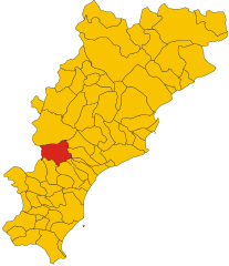
Pietra Ligure (Pietra Ligure)
.svg)
- Italian comune
 Hiking in Pietra Ligure
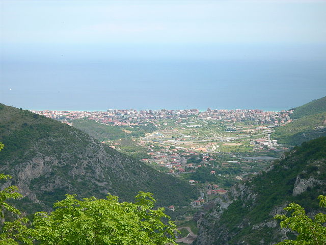
Pietra Ligure is a charming coastal town located in the Liguria region of northwest Italy, known for its beautiful beaches and picturesque landscapes. Hiking in and around Pietra Ligure offers stunning views of the Mediterranean Sea, lush vegetation, and the rugged terrain of the surrounding hills.
Hiking Trails:
-
Monte Carmo di Prino: This is one of the prominent peaks near Pietra Ligure. The trail rewards hikers with panoramic views of the coastline and the surrounding mountains. The trek can be moderate to challenging, making it suitable for those with some hiking experience.
-
Path of the Bell Tower (Sentiero dei Campanili): A scenic hike that leads through old pathways connecting various rural churches and towers. This trail allows hikers to experience local history and architecture while enjoying the surrounding nature.
-
Finalese Trails: The nearby Finalborgo area offers a network of trails within the stunning Natural Park of Finalese. These trails range from easy to challenging and take you through ancient ruins, medieval villages, and breathtaking landscapes.
-
Cascate di Nardèi: A lovely hike that leads to waterfalls found in the hills above Pietra Ligure. This relatively easy trail is perfect for families and features beautiful nature along the way.
Tips for Hiking in Pietra Ligure:
- Weather: Always check the weather conditions before heading out, as they can change quickly in coastal areas.
- Gear: Wear appropriate hiking shoes and bring enough water, snacks, and a fully charged phone for navigation and emergencies.
- Respect Nature: Stay on marked trails and respect the local flora and fauna to preserve the natural beauty of the area.
- Guided Tours: Consider joining guided hikes if you are unfamiliar with the area. This can enhance your experience and provide local insights.
Best Time to Hike:
The best months for hiking in Pietra Ligure are spring (April to June) and autumn (September to October), when the weather is mild and the landscapes are particularly beautiful.
Hiking in Pietra Ligure combines fresh air, natural beauty, and cultural heritage, making it a rewarding experience for outdoor enthusiasts. Enjoy your hike!
- Country:

- Postal Code: 17027
- Local Dialing Code: 019
- Licence Plate Code: SV
- Coordinates: 44° 8' 55" N, 8° 16' 58" E


- GPS tracks (wikiloc): [Link]
- AboveSeaLevel: 3 м m
- Area: 9.88 sq km
- Population: 8837
- Web site: http://www.comunepietraligure.it
- Wikipedia en: wiki(en)
- Wikipedia: wiki(it)
- Wikidata storage: Wikidata: Q271152
- Wikipedia Commons Category: [Link]
- Freebase ID: [/m/0gb_1n]
- GeoNames ID: Alt: [6537052]
- VIAF ID: Alt: [245386276]
- OSM relation ID: [42911]
- archINFORM location ID: [11700]
- PACTOLS thesaurus ID: [pcrtp9aS7dk509]
- MusicBrainz area ID: [66165653-66eb-4baf-aa0b-e57aae70509d]
- ISTAT ID: 009049
- Italian cadastre code: G605
Shares border with regions:

Bardineto
- Italian comune
Hiking in Bardineto
Bardineto is a picturesque village located in the Liguria region of Italy, nestled within the lush countryside of the province of Savona. The area is characterized by its stunning natural landscapes, rolling hills, and mountainous terrain, making it an excellent destination for hiking enthusiasts....
- Country:
- Postal Code: 17057
- Local Dialing Code: 019
- Licence Plate Code: SV
- Coordinates: 44° 11' 32" N, 8° 7' 45" E
- GPS tracks (wikiloc): [Link]
- AboveSeaLevel: 711 м m
- Area: 29.79 sq km
- Population: 744
- Web site: [Link]


Boissano
- Italian comune
Hiking in Boissano
Boissano is a quaint Italian village located in the Liguria region, close to the coastline of the Mediterranean Sea. The area around Boissano is known for its stunning landscapes, which include picturesque hills, valleys, and coastal views, making it an excellent destination for hiking enthusiasts of all levels....
- Country:
- Postal Code: 17054
- Local Dialing Code: 0182
- Licence Plate Code: SV
- Coordinates: 44° 8' 4" N, 8° 13' 17" E
- GPS tracks (wikiloc): [Link]
- AboveSeaLevel: 121 м m
- Area: 8.35 sq km
- Population: 2474
- Web site: [Link]


Borgio Verezzi
- Italian comune
Hiking in Borgio Verezzi
Borgio Verezzi is a beautiful location in the Liguria region of Italy, nestled between the mountains and the sea. The area is known for its stunning landscapes, charming villages, and a variety of hiking trails that cater to different skill levels. Here’s what you need to know about hiking in Borgio Verezzi:...
- Country:
- Postal Code: 17022
- Local Dialing Code: 019
- Licence Plate Code: SV
- Coordinates: 44° 9' 36" N, 8° 18' 17" E
- GPS tracks (wikiloc): [Link]
- AboveSeaLevel: 323 м m
- Area: 2.73 sq km
- Population: 2203
- Web site: [Link]


Giustenice
- Italian comune
Hiking in Giustenice
Giustenice, a small town located in the Province of Savona in the Italian region of Liguria, offers a range of beautiful hiking opportunities. The surrounding landscapes feature rolling hills, olive groves, and Mediterranean vegetation, making it an excellent destination for nature enthusiasts and hikers....
- Country:
- Postal Code: 17027
- Local Dialing Code: 019
- Licence Plate Code: SV
- Coordinates: 44° 10' 20" N, 8° 14' 46" E
- GPS tracks (wikiloc): [Link]
- AboveSeaLevel: 140 м m
- Area: 17.22 sq km
- Population: 998
- Web site: [Link]

Loano
- Italian comune
Hiking in Loano
Loano is a charming coastal town located on the Italian Riviera in the Liguria region. It offers a variety of hiking opportunities that cater to different skill levels and preferences. Here are some highlights of hiking in and around Loano:...
- Country:
- Postal Code: 17025
- Local Dialing Code: 019
- Licence Plate Code: SV
- Coordinates: 44° 7' 44" N, 8° 15' 35" E
- GPS tracks (wikiloc): [Link]
- AboveSeaLevel: 5 м m
- Area: 13.48 sq km
- Population: 11224
- Web site: [Link]


Tovo San Giacomo
- Italian comune
Hiking in Tovo San Giacomo
Tovo San Giacomo is a beautiful village located in the Liguria region of Italy, nestled within the wider context of the Italian Riviera and the surrounding Apennine Mountains. It offers a variety of hiking opportunities, characterized by stunning landscapes, picturesque villages, and a diverse range of flora and fauna....
- Country:
- Postal Code: 17020
- Local Dialing Code: 019
- Licence Plate Code: SV
- Coordinates: 44° 10' 36" N, 8° 16' 6" E
- GPS tracks (wikiloc): [Link]
- AboveSeaLevel: 47 м m
- Area: 9.45 sq km
- Population: 2543
- Web site: [Link]